Impact on urban form of the new Social Housing projects developed in Costa Rica
←
→
Transcripción del contenido de la página
Si su navegador no muestra la página correctamente, lea el contenido de la página a continuación
ISSN 1011-484X • e-ISSN 2215-2563
                                                                               Número 68(1) • Enero-junio 2022
                                                            Doi: http://dx.doi.org/10.15359/rgac.68-1.6 Páginas
                                                                                              de la 157 a la 186
                                                                 Recibido: 26/10/2020 • Aceptado: 09/02/2021
                                                            URL: www.revistas.una.ac.cr/index.php/geografica/

    Impact on urban form of the new Social Housing projects
                   developed in Costa Rica*

    El impacto sobre la forma urbana de los nuevos proyectos de
             Vivienda de Interés Social en Costa Rica1

                                                            Helga von Breymann Miranda2
                                                     Universidad de Costa Rica, Costa Rica
                                                          Valeria Alexandra Chacón Reyes3
                                                     Universidad de Costa Rica, Costa Rica
                                                                Mauricio Ramírez Ramírez4
                                                     Universidad de Costa Rica, Costa Rica
                                                                  Lucía Rodríguez Ramírez5
                                                     Universidad de Costa Rica, Costa Rica
                                                                      Paola Rojas Álvarez6
                                                     Universidad de Costa Rica, Costa Rica
                                                                    Andrés Mora Sandoval7
                                                     Universidad de Costa Rica, Costa Rica
*    Este texto es una traducción literal del artículo “El impacto sobre la forma urbana de los nuevos proyectos
     de Vivienda de Interés Social en Costa Rica”, incluido en este mismo número.
1    A preliminary version of this work was presented at the IV ISUF-H Barcelona 2020 Congress.
2    Escuela de Arquitectura, Universidad de Costa Rica. Email: helga.vonbreymann@ucr.ac.cr            https://or-
     cid.org/0000-0002-6841-5953
3    Arquitecta. Escuela de Arquitectura, Universidad de Costa Rica. Email: valeria.chacon@ucr.ac.cr
         https://orcid.org/0000-0002-6067-4854
4    Arquitecto. Escuela de Arquitectura, Universidad de Costa Rica. Email: mauricio.ramirezramirez@ucr.
     ac.cr    https://orcid.org/0000-0001-9262-5013
5    Arquitecta. Escuela de Arquitectura, Universidad de Costa Rica. Email: lucia.rodriguezramirez@ucr.ac.cr
        https://orcid.org/0000-0002-6743-6664
6    Arquitecta. Escuela de Arquitectura, Universidad de Costa Rica. Email: paola.rojasalvarez@ucr.ac.cr
         https://orcid.org/0000-0003-2578-3542
7    Arquitecto. Escuela de Arquitectura, Universidad de Costa Rica. Email: andres.morasandoval@ucr.ac.cr
        https://orcid.org/0000-0002-6938-0588

                                                                                                            157
Helga von Breymann Miranda - Mauricio Ramírez Ramírez - Lucía Rodríguez Ramírez
                                                              Paola Rojas Álvarez - Andrés Mora Sandoval
       El impacto sobre la forma urbana de los nuevos proyectos de Vivienda de Interés Social en Costa Rica

ABSTRACT
In Costa Rica, the social housing (VIS) projects developed in the last decade have been located in
areas far from urban centers of limited access to facilities and infrastructure due to the prohibitive
cost of land ownership in most central sectors of metropolitan cities. The conditions and charac-
teristics of these contexts, available land uses (zoning), morphological configurations, continuity
and contiguity between social housing projects and the urban pieces where they are inserted, are
analyzed in this research through the study of five residential complexes developed in the Greater
Metropolitan Area of Costa Rica. The projects, built between 2011 and 2018, were analyzed from
the study of construction plans, cartography of the area, documentary review and analysis of sec-
ondary data. From the obtained results it is possible to identify the main difficulties arising from the
morphological and typological fit that followed after the establishment of the residential complexes,
as well as the contextual problems derived from the location of the projects.

Keywords: Urban configuration; Residential complexes; Urban morphology; Urban planning; So-
cial Housing.

Resumen
En Costa Rica, los proyectos de vivienda de interés social desarrollados en la última década se han
localizado en zonas alejadas de centros urbanos o con limitado acceso a equipamientos e infraes-
tructuras, debido al elevado costo del suelo en los sectores más céntricos de la ciudad. Las condi-
ciones y características de estos entornos, los usos del suelo, las configuraciones morfológicas, la
continuidad y la contigüidad entre los proyectos de Vivienda de Interés Social y las piezas urbanas
donde se insertan, son analizadas en esta investigación, a través del estudio de cinco conjuntos
residenciales desarrollados en la Gran Área Metropolitana. Los proyectos, construidos entre 2011 y
2018, fueron analizados a partir del estudio de planos, cartografía del ámbito, revisión documental
y estudio de datos secundarios. Los resultados alcanzados posibilitaron identificar las principales
dificultades desprendidas del encaje morfológico y tipológico que siguieron los conjuntos residen-
ciales, así como las problemáticas contextuales por la locación de los proyectos.

Palabras clave: Configuración urbana, Conjuntos residenciales, Morfología urbana, Planificación
urbana, Vivienda de Interés Social.

       INTRODUCTION
       In recent years, many of the so-called social housing projects (VIS)
in Costa Rica were built in areas lacking in infrastructure and urban fa-
cilities due to the difficulty of accessing cheap land in the most central
sectors of the city. This has supposed disadvantageous conditions for these
residential complexes and thus limited the opportunities of their residents
to access goods and services commensurate with daily life and to secure a
good quality of life.
       The study of urban morphology emerges as a theoretical-method-
ological approach that enables a greater understanding of the implications
of urban form and its effects on the social dimension. The limited diversity

158     Revista Geográfica de América Central. Nº 68(1)
        ISSN 1011-484X • e-ISSN 2215-2563 / Enero-junio 2022
        Doi: http://dx.doi.org/10.15359/rgac.68-1.6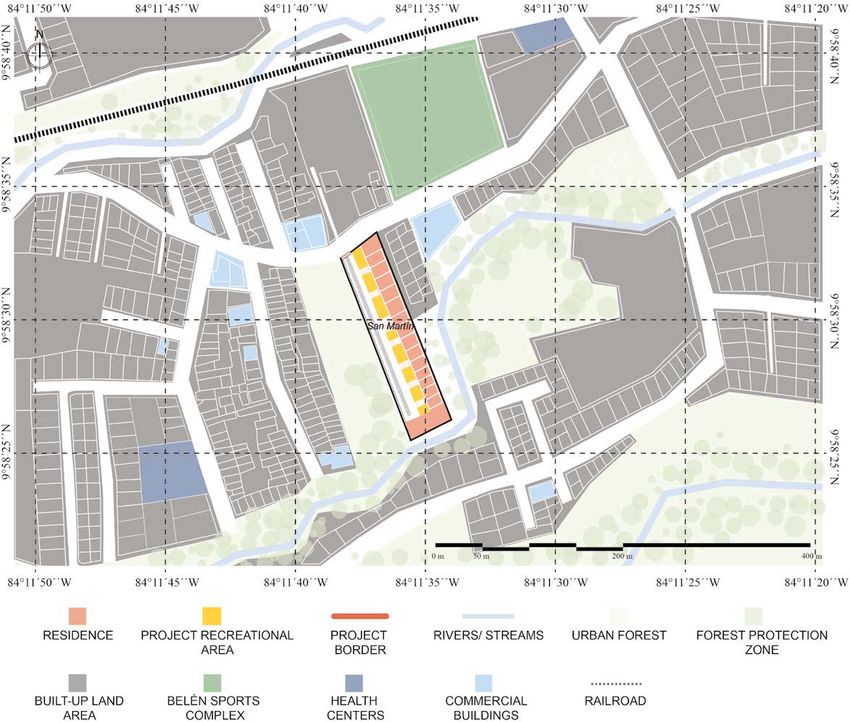
Helga von Breymann Miranda - Mauricio Ramírez Ramírez - Lucía Rodríguez Ramírez
Paola Rojas Álvarez - Andrés Mora Sandoval
Impact on urban form of the new Social Housing projects developed in Costa Rica

in land uses, the absence of continuity in the urban layout or the existence
of barriers are just some of the manifestations that are evidenced when
there are flaws in the morphological fit of new pieces within existing and
poorly balanced urban frameworks, developed without adequate urban
planning and control.
       In Costa Rica, the development of Social Housing involves various
actors, primarily developers ―who assume the task of planning and de-
veloping the residential complexes― and the Banco Hipotecario para la
Vivienda (BANHVI) [translated as Mortgage Bank for Housing], a gov-
ernment banking institution which reviews, finances and supervises the
execution of said residential projects.
       Land selection for the construction of houses is carried out by devel-
opers and the government counterpart (government institutions) verifies
the compliance of technical requirements. This methodology has made
possible the development of new decontextualized public housing devel-
opments suffering from significant deficiencies. The selection of the land
not only lacks clear procedures but is also based on inadequate basic tech-
nical requirements with deficient criteria that do not include substantial
elements to ensure access to some services and infrastructure necessary for
providing the residents of said projects with a good quality of life.
       Furthermore, there is an important void in the procedures that would
allow the execution of typologically congruent developments and in con-
sonance with the urban landscape of the context in which they are devel-
oped, which is generating important fractures in the continuity, legibility
and urban landscape of many sectors of cities.
       In light of this, the morphological study of the urban pieces where
VIS projects are inserted is revealing and allows the formulation of strate-
gies that favor a better urban-architectural articulation to improve the qual-
ity of life its inhabitants, key aspect in understanding the dialectic between
physical space and society, as stated by Halbach in his writings on social
morphology (Martínez, 2003).
       Following Capel (2002), urban morphology and the built environment
reflect the social and economic organization, as well as the political struc-
tures of the dominant social groups. Therefore, the analysis of urban struc-
ture, its arrangement, connections, typologies, etc., are key to understanding
the complexity of urban environments. Functional problems in certain city

                                                  Revista Geográfica de América Central. Nº 68(1)   159
                                                 ISSN 1011-484X • e-ISSN 2215-2563 / Enero-junio 2022
                                                     Doi: http://dx.doi.org/10.15359/rgac.68-1.6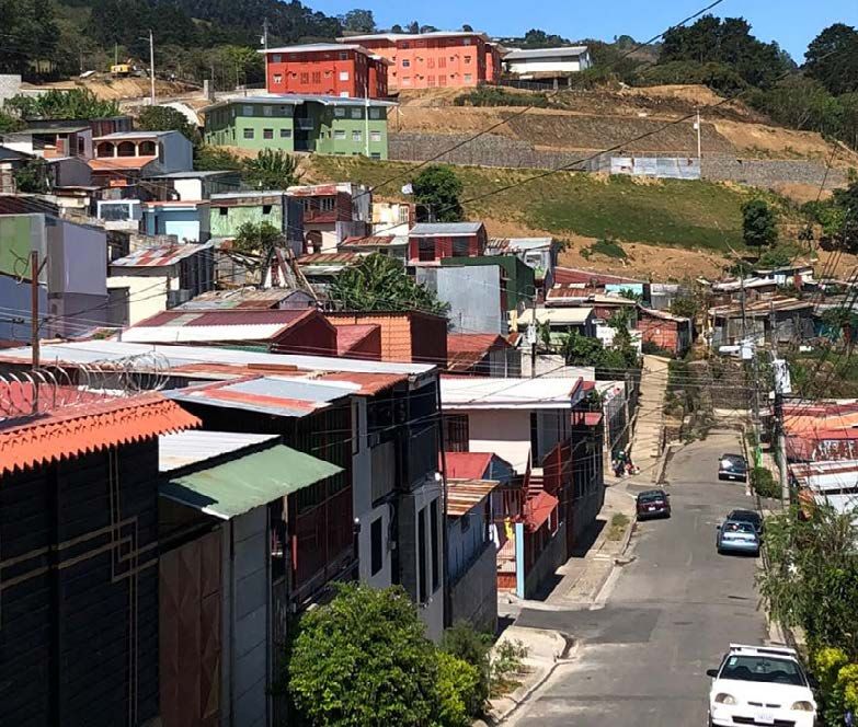
Helga von Breymann Miranda - Mauricio Ramírez Ramírez - Lucía Rodríguez Ramírez
                                                             Paola Rojas Álvarez - Andrés Mora Sandoval
      El impacto sobre la forma urbana de los nuevos proyectos de Vivienda de Interés Social en Costa Rica

environments manifest the weaknesses entailed in the organization of forms
and urban management processes, and reinforce the need for a dynamic and
global approach to the environment and forms (Munizaga, 2000).
       In line with this argument, the location of tertiary economic activ-
ities, and mainly, their territorial extension as pointed out by Christaller
(1933), are also determining factors in understanding the dynamics of the
city and its layout.
       To embark on the subject matter from the urban design perspective,
as proposed for several decades by authors such as Christopher Alexan-
der (1964) with the study of complexity and urban relations, or Fumihiko
Maki (1964) through the understanding of the various modes of aggrega-
tion or association of urban forms, has enabled a better comprehension of
the effects of morphological elements in the development of cities.
       Other approximations, such as that of Oliveira (2013), seek to assess
the maturity of urban processes, for which they combine accessibility vari-
ables such as spatial accessibility of the street system, year of construction
of buildings, parcel density, alignment of buildings, the dimension of street
blocks, the ratio between height of buildings and street width, and the uses
given to the buildings. Regardless of how it is approached, this type of
analysis has been able to demonstrate that both urban variety, as well as
the location of infrastructure, services, commerce, etc., in the territory, are
fundamental for the provision of spatial conditions necessary for a good
quality of life of its residents (González, 2000).
       In Costa Rica, studies on urban morphology are scarce, however
contributions have been made from the disciplines of geography and his-
tory by way of analysis of the evolution of the urban structure and its link
with productive transformations (Quesada, 2014); the urban hierarchy of
urban cores (Hall, 1974); the impact upon the urban layout with regard to
the perception of security and coexistence relations (Barrantes, 2019); and
other more concrete contributions on specific neighborhoods, such as the
study by Gómez, Guillén and Salas (2018) carried out to understand the
evolution and transformation of the urban layout and the dynamics of a
central neighborhood in Costa Rica.
       Based on the above, the objective of the present study is to evaluate,
from a morphological approach, the urban and typological fabric of the
surroundings in which social housing projects are located, based on the

160   Revista Geográfica de América Central. Nº 68(1)
      ISSN 1011-484X • e-ISSN 2215-2563 / Enero-junio 2022
      Doi: http://dx.doi.org/10.15359/rgac.68-1.6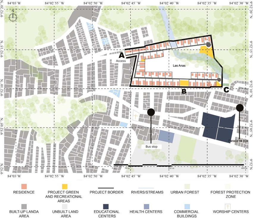
Helga von Breymann Miranda - Mauricio Ramírez Ramírez - Lucía Rodríguez Ramírez
Paola Rojas Álvarez - Andrés Mora Sandoval
Impact on urban form of the new Social Housing projects developed in Costa Rica
analysis of five cases developed in the Greater Metropolitan Area (GMA)
of Costa Rica in recent years.
The study allows to advance evidence regarding urban practices re-
lated to the development of VIS, through complementary diagnoses and
analyses, to enable the promotion of procedures for improving the loca-
tion, configuration and fit of these projects within the surrounding urban
pieces where they are constructed.
METHODOLOGY
The research was based on the case study methodology. Five Social Hous-
ing projects, located in different districts of the Greater Metropolitan Area (GMA)
of Costa Rica, were selected possessing different characteristics. The five proj-
ects were analyzed in terms of the impact of their location on the surroundings
and the effects of urban layout on the project. The study is of descriptive-analyti-
cal nature and is prepared from documentary review and cartographic, planimet-
ric and photographic analysis of the selected geographical areas.
The procedure for the study was structured from the analysis of
three basic elements of morphological studies, namely: typology and ur-
ban structure, land use and analysis of the continuity of the urban layout
(Capel, 2002). Hence, a survey of the following morphological elements
was developed at the meso and micro levels:
a. Services, land endowments destined for public use and public facili-
ties, and main infrastructure.
b. Main roads network, hierarchy and connectivity.
c. Green areas, urban forests and vacant areas.
d. Layout of parcels and building typologies.
At the meso level, the urban context within a radius of 1 kilometer
from the project was analyzed as this was considered an accessible dis-
tance for the entire population. The proximity, connectivity and structure
of the urban fabric of the locations were studied to understand the context
in which these urban pieces are inserted. At the micro level, the urban
piece of each residential complex and its immediate context were evaluat-
ed to observe in greater detail aspects of morphology, project typology and
fit, while considering existing aspects of continuity and contiguity.
Revista Geográfica de América Central. Nº 68(1) 161
ISSN 1011-484X • e-ISSN 2215-2563 / Enero-junio 2022
Doi: http://dx.doi.org/10.15359/rgac.68-1.6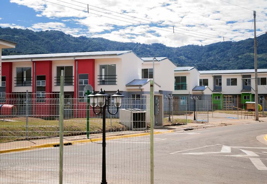
Helga von Breymann Miranda - Mauricio Ramírez Ramírez - Lucía Rodríguez Ramírez
                                                             Paola Rojas Álvarez - Andrés Mora Sandoval
      El impacto sobre la forma urbana de los nuevos proyectos de Vivienda de Interés Social en Costa Rica

      Once the information had been collected and registered through the
creation of various maps, an analysis was carried out and the five case
studies were compared, from which conclusions and recommendations
were drawn for consideration.

       Case studies
       The selected case studies are located in the Greater Metropolitan Area of
Costa Rica (see map 1), a geographical area that concentrates over 52.7% of
Costa Rica’s population (INEC, 2011); the corresponding VIS projects were
constructed between the years 2011 and 2018. Case selection took into con-
sideration the residential typologies of the projects, the quantity of constructed
houses, and geographical location, seeking to adequately represent the urban-
istic diversity existing across the entire Greater Metropolitan Area.
       In the following section, the five selected case studies are presented
and their geographical contextualization reviewed, followed by an analy-
sis of the morphological elements of the urban context of their localities.

                     Map 1. Location of the selected projects.

                                     Source: Own elaboration.

162   Revista Geográfica de América Central. Nº 68(1)
      ISSN 1011-484X • e-ISSN 2215-2563 / Enero-junio 2022
      Doi: http://dx.doi.org/10.15359/rgac.68-1.6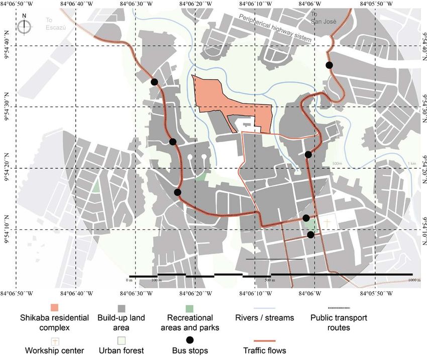
Helga von Breymann Miranda - Mauricio Ramírez Ramírez - Lucía Rodríguez Ramírez
Paola Rojas Álvarez - Andrés Mora Sandoval
Impact on urban form of the new Social Housing projects developed in Costa Rica

       Las Anas Residential Project
       The Las Anas is a Social Housing Condominium located in sector
4 of the district of Los Guido, in the canton of Desamparados, province
of San José. Desamparados is one of the most densely populated cantons
in the Greater Metropolitan Area and is home to a large number of social
housing projects and several informal settlements. The Los Guido dis-
trict accelerated its urbanization process starting in 1986, during the first
presidency of Oscar Arias, mainly due to the creation of the government
aid program “Bono de Familia” (translated as Family Bond), and result-
ed in the development of a significant number of VISs in this sector. The
aid program provided housing opportunities to foreign and national fam-
ilies from all over the country, who lived in poverty and lacked access to
housing and basic services.
       The Las Anas Condominium, completed in 2018, was carried out by
the Fundación Promotora de Vivienda (FUPROVI). The project was pro-
posed with the aim of eradicating the Las Palmas informal settlement, thus
providing housing for a total of 198 families in dire need.
       From the cartographic analysis of the existing urban development
in the area, it stands out that the growth of the sector has been taking
place irregularly over a mostly flat territory. An urban layout following a
    Figure 1. Photograph of Las Anas Condominium                   specific pattern
                                                                   was not ini-
                                                                   tially defined,
                                                                   instead      the
                                                                   layout      was
                                                                   constructed
                                                                   spontaneously
                                                                   as the popula-
                                                                   tion expand-
                                                                   ed. A road
                                                                   hierarchy      is
                                                                   identified and
                                                                   reflected in the
                                                                   two main roads
   Source: FUPROVI (Fundación Promotora de Vivienda, translated as that cross and
                 Housing Promotion Foundation).                    give access to

                                                  Revista Geográfica de América Central. Nº 68(1)   163
                                                 ISSN 1011-484X • e-ISSN 2215-2563 / Enero-junio 2022
                                                     Doi: http://dx.doi.org/10.15359/rgac.68-1.6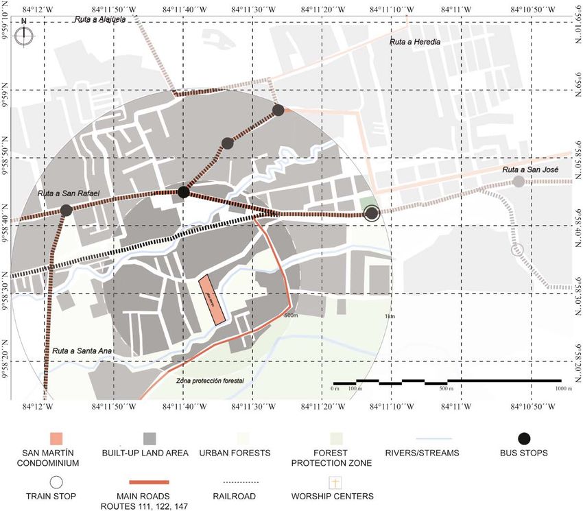
Helga von Breymann Miranda - Mauricio Ramírez Ramírez - Lucía Rodríguez Ramírez
                                                             Paola Rojas Álvarez - Andrés Mora Sandoval
      El impacto sobre la forma urbana de los nuevos proyectos de Vivienda de Interés Social en Costa Rica

the district (see Map 2) and from which stem secondary roads that provide
limited redundancy. The two primary axes provide continuity in mobility
and access to the city center of Desamparados, located at a distance of 5.3
km. A homogeneous division into blocks is not identified, although rect-
angular blocks prevail and the division into small-size lots with residential
typologies of one or two-level single-family housing dominate.

         Map 2. Surroundings of the Las Anas Residential Project.

                         Source: Own elaboration from satellite images.

       Regarding land use, residential use predominates and a significant va-
riety of commerce and services buildings are observed. Within a radius of
1000 meters from the project, other basic facilities such as educational centers,
health centers, churches and recreational parks are located. According to the
Zoning Ordinance Plan (known in Costa Rica as Plan Regulador) of the Mu-
nicipality of Desamparados (Municipalidad de Desamparados, n.d.), the area
where the project is located is classified as Low Density Residential Zone and
existing green and recreational areas belong to a Forest Protection Zone.

164   Revista Geográfica de América Central. Nº 68(1)
      ISSN 1011-484X • e-ISSN 2215-2563 / Enero-junio 2022
      Doi: http://dx.doi.org/10.15359/rgac.68-1.6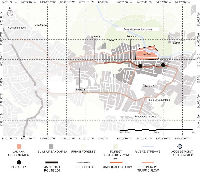
Helga von Breymann Miranda - Mauricio Ramírez Ramírez - Lucía Rodríguez Ramírez
Paola Rojas Álvarez - Andrés Mora Sandoval
Impact on urban form of the new Social Housing projects developed in Costa Rica

        The project consists of 73 two-level buildings, distributed in 37 lots and
has two outdoor recreational spaces (i.e., green and recreational areas) and a
commercial zone. Each lot corresponds to a residential condominium with an
average area of 480 m2; all condominiums are connected by public roads, form-
ing a condominium housing complex with only one access point. Each condo-
minium is comprised of an average of five houses and three parking spaces.
        In general, the housing solutions present the same programmatic characteris-
tics, although organized in four different residential typologies: 47.5 m2 single-fam-
ily house (two bedrooms), 54.9 m2 single-family house (three bedrooms), 56.5 m2
single-family house (two bedrooms, designed for people with disabilities) and a
64.3 m2 single-family house (three bedrooms, designed for people with disabilities).
        In terms of connectivity and contiguity, the project has a single re-
stricted access point (sector A) (see Map 3). The entire perimeter is de-
limited by a wall, which restricts accessibility and connection with the
exterior. Despite the latter characteristics, the project has two sectors that
could be enabled as access points (see Map 3, sectors B and C).

Map 3. Immediate context and distribution of the Las Anas Residential Project.

                         Source: Own elaboration from satellite images.

                                                  Revista Geográfica de América Central. Nº 68(1)   165
                                                 ISSN 1011-484X • e-ISSN 2215-2563 / Enero-junio 2022
                                                     Doi: http://dx.doi.org/10.15359/rgac.68-1.6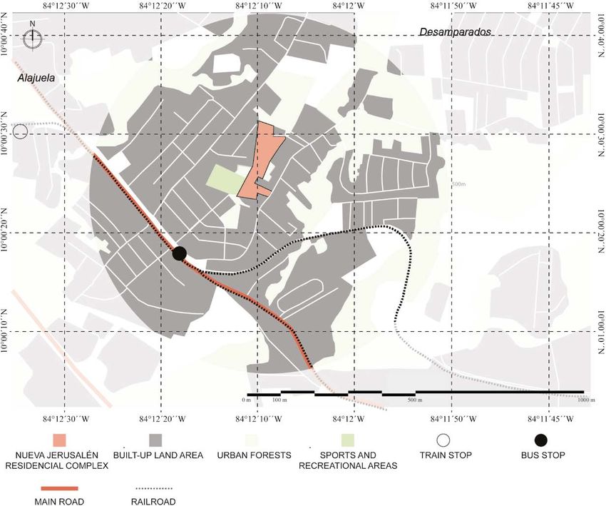
Helga von Breymann Miranda - Mauricio Ramírez Ramírez - Lucía Rodríguez Ramírez
                                                             Paola Rojas Álvarez - Andrés Mora Sandoval
      El impacto sobre la forma urbana de los nuevos proyectos de Vivienda de Interés Social en Costa Rica

      The housing project is crossed by a stream, which generates a green
corridor and establishes a direct connection with the natural environment
that surrounds the land plot. It is a resource that allows aperture of the
project to its context and creates a break in the project’s landscape and
form, as it divides the project in two. It constitutes a vegetation barrier,
running south to north, that serves as the prelude to the protected forest
zone located at the north backend of the project. Scenically, the barrier is
a grand void that engulfs practically half of the project’s land plot. At the
meso scale, this void functions as a separating element between the hous-
ing complex and the city center (i.e., downtown Desamparados).
      Internally, the project breaks with the irregular morphology of the sur-
rounding sector, as it presents an orderly arrangement of houses and also, be-
cause it is comprised of condominiums that follow a disposition, both physical
and functional. There is no clear contiguity with the adjacent sectors.

       Shikaba Residential Project
       The Shikaba Residential Complex is a Social Housing (VIS) project,
developed under the figure of a housing complex by the developer FUPROVI,
which benefited 254 low-income families living in extreme poverty. It is lo-
cated in the Alajuelita district, of the Alajuelita canton, province of San José.
It was completed in 2019 but as a result of bureaucratic delays and the public
health emergency caused by COVID-19, the project was delivered a year lat-
er, in December 2020.               Figure 2. Aerial view of the Shikaba
Similar in outcome to                  Residential Residential Project
the Los Guido district,
the appearance of the
“Bono de Familia” gov-
ernment aid program in
the 1980s, saw Alajuel-
ita become one of the
cantons with the great-
est development of so-
cial housing projects.
       The accelerated
arrival of socioeco-
nomically vulnerable                            Source: FUPROVI.

166   Revista Geográfica de América Central. Nº 68(1)
      ISSN 1011-484X • e-ISSN 2215-2563 / Enero-junio 2022
      Doi: http://dx.doi.org/10.15359/rgac.68-1.6
Helga von Breymann Miranda - Mauricio Ramírez Ramírez - Lucía Rodríguez Ramírez
Paola Rojas Álvarez - Andrés Mora Sandoval
Impact on urban form of the new Social Housing projects developed in Costa Rica
populations and the lack of urban planning caused, over time, a stark seg-
regation that had an impact on urban transformation.
The urban layout of downtown Alajuelita is regular, however as one
moves north towards the project it turns more irregular. Furthermore, in
the sector where Shikaba is located, a small-size parcel composition can
be identified with limited presence of large-size plots. The project is sur-
rounded by the Tiribí River to the north, La Guaria Stream to the west and
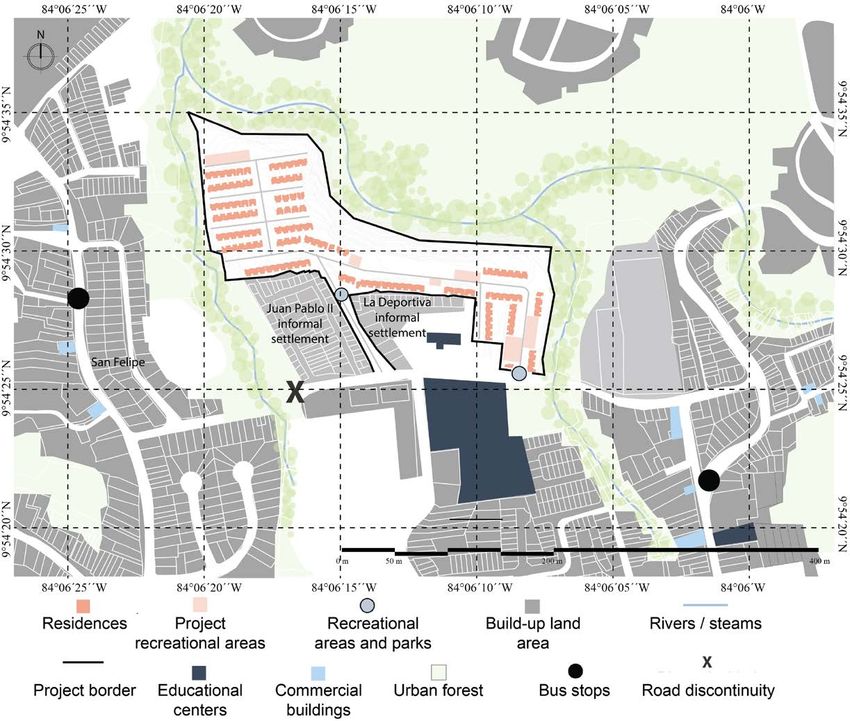
the Mancha Stream to the east. The south side leads to the only access road
and adjoins the informal settlements of Juan Pablo II and La Deportiva,
erected since 1982 and 1997, respectively.
The district has a main access road which connects with the Anillo
de Circunvalación, a main peripheral vehicular highway system connecting
with the capital city of San José (see Map 4). This peripheral system consti-
tutes at the same time an important physical border at the pedestrian level
Map 4. Surroundings of the Shikaba Residential Complex.
Source: Own elaboration from satellite images.
Revista Geográfica de América Central. Nº 68(1) 167
ISSN 1011-484X • e-ISSN 2215-2563 / Enero-junio 2022
Doi: http://dx.doi.org/10.15359/rgac.68-1.6Helga von Breymann Miranda - Mauricio Ramírez Ramírez - Lucía Rodríguez Ramírez
Paola Rojas Álvarez - Andrés Mora Sandoval
El impacto sobre la forma urbana de los nuevos proyectos de Vivienda de Interés Social en Costa Rica
by virtue of narrow sidewalks of less than 1.5 meters wide, few pedestrian
bridges, insufficient urban furniture and vegetation, all negatively affecting
pedestrian connectivity. The access road to the project also connects directly
with the district’s main highway on the east and south sectors, but lacks con-
nection with the west sector of San Felipe de Alajuelita, due to the absence
of road infrastructure over the La Guaria Stream thus affecting the accessi-
bility and proximity to services found in the western sector (see Map 5).
Map 5. Immediate context and distribution of the Shikaba Residential
Complex.
Source: Own elaboration from satellite images.
Regarding the land use of the studied area, within a radius of 1000
meters the project is provided with essential utilities and services, as well
as high schools and health centers. Land use is primarily residential with
one or two-level single-family houses.
168 Revista Geográfica de América Central. Nº 68(1)
ISSN 1011-484X • e-ISSN 2215-2563 / Enero-junio 2022
Doi: http://dx.doi.org/10.15359/rgac.68-1.6Helga von Breymann Miranda - Mauricio Ramírez Ramírez - Lucía Rodríguez Ramírez
Paola Rojas Álvarez - Andrés Mora Sandoval
Impact on urban form of the new Social Housing projects developed in Costa Rica
The housing complex is made up of 244 single-family houses erect-
ed using a masonry construction system with concrete blocks and offered
in six different typologies: Type 1 is a two-level construction with an area
of 53 m2 (two bedrooms), Type 2 is two-level and 54.4 m2 (two bedrooms),
Type 3 is two-level and 65.2 m2 (three bedrooms), Type 4 is two-level and
63.3 m2 (three bedrooms), Type 5 is one-level and 52 m2 (two bedrooms,
designed for people with disabilities) and Type 6 is two-level and 71.1 m2
(two bedrooms, adapted for the elderly).
Within the bounds of the housing complex, the design contemplated
a parking lot, five playground areas for children, three communal facilities,
29 residential-commercial mixed-use lots, 215 residential-use lots, as well
as a vast park area to be reforested, which adjoin the protection zones of
the Tiribí River and La Guaria and Mancha Streams.
The design of the housing complex responds to the optimization of
space in an irregular shaped lot by fitting the greatest possible number of
houses and realizing the reforestation of common areas and parks adjacent
to the protected area along the banks of the river and streams. The presence
of both streams and the Tiribí River define the topographic characteristics
of the site. This is located on a terrain with a steep slope to the north cre-
ated by the presence of the river, while the west and east sides are both
embraced by streams that create less pronounced slopes. These bodies of
water and the vegetation cover enrich the housing complex with a natural
border that separates it from its surroundings. In addition, the distribution
of the houses by rows is highly contrasting and breaks with the irregularity
of the urban fabric, thus the project is perceived even more detached from
its immediate context.
Nueva Jerusalén Residential Project
The Nueva Jerusalén Residential Project is located in the Desam-
parados district of the Alajuela canton, province of Alajuela. The project is
located in an urbanized area 2.5 km from downtown Alajuela. The project
was developed by the company Construcciones Modulares de Costa Rica
S.A., during 2011, with the aim of eradicating an informal settlement in-
stalled on the same land plot, thus providing new housing for 56 families.
Historically, this area has been mostly of residential use, a situ-
ation that has changed little to date. The main changes, in terms of the
Revista Geográfica de América Central. Nº 68(1) 169
ISSN 1011-484X • e-ISSN 2215-2563 / Enero-junio 2022
Doi: http://dx.doi.org/10.15359/rgac.68-1.6Helga von Breymann Miranda - Mauricio Ramírez Ramírez - Lucía Rodríguez Ramírez
Paola Rojas Álvarez - Andrés Mora Sandoval
El impacto sobre la forma urbana de los nuevos proyectos de Vivienda de Interés Social en Costa Rica
Figure 3. Photograph of the Nueva Jerusalén morphological elements
Residential Project of the area, respond to an
increase in housing den-
sity mainly due to a slight
increase in the built-up
land footprint.
The topography of
the Desamparados dis-
trict is regular, although it
exhibits some slopes as-
sociated with the course
of some rivers, which
have been decisive in the
Source: Colegio Federado de Ingenieros y Arquitectos, 2013. configuration of the ac-
cess roads to this sector.
Map 6. Analysis of the built-up land footprint and vacant areas in the
immediate context of the Nueva Jerusalén Residential Project.
Source: Own elaboration from satellite images.
From the study of the morphological configuration of the site,
it is observed that it is quite irregular (see map 7), in contrast to the
distinctive squared urban grid of downtown Alajuela. At the district
170 Revista Geográfica de América Central. Nº 68(1)
ISSN 1011-484X • e-ISSN 2215-2563 / Enero-junio 2022
Doi: http://dx.doi.org/10.15359/rgac.68-1.6Helga von Breymann Miranda - Mauricio Ramírez Ramírez - Lucía Rodríguez Ramírez
Paola Rojas Álvarez - Andrés Mora Sandoval
Impact on urban form of the new Social Housing projects developed in Costa Rica
level, the absence of planning prohibited the expansion of the regular
urban fabric starting from orthogonal blocks, but rather gave way to an
irregular development of small-size parcels, linked to road axes of low
hierarchy and to multiple agricultural zones interspersed within new
urbanized pieces.
Map 7. Surroundings of the Nueva Jerusalén Residential Complex.
Source: Own elaboration from satellite images.
The zoning in this area is primarily residential, exhibiting mostly
one-level buildings, nonetheless, the vicinity also presents some agri-
cultural land use zones. Its strategic location has influenced the nearby
availability of urban facilities and urban services such as worship cen-
ters, sports, health and educational facilities. At a greater distance, the
urban city center of Alajuela offers parks, commerce, cultural spaces and
other services.
Revista Geográfica de América Central. Nº 68(1) 171
ISSN 1011-484X • e-ISSN 2215-2563 / Enero-junio 2022
Doi: http://dx.doi.org/10.15359/rgac.68-1.6Helga von Breymann Miranda - Mauricio Ramírez Ramírez - Lucía Rodríguez Ramírez
Paola Rojas Álvarez - Andrés Mora Sandoval
El impacto sobre la forma urbana de los nuevos proyectos de Vivienda de Interés Social en Costa Rica
The project was developed adjacent to a major road axis, which con-
nects the center of the consolidated city of Alajuela with other main cities
such as Heredia and San José.
Regarding the configuration of the project, a main road axis that
crosses from north to south is identified, which, in turn, connects with the
“Pasito” public road through a street and a non-vehicular avenue (in Span-
ish “alameda”) existing on the site (see Map 8).
Despite the project’s strategic location, connecting axes only exist on
the east side, although most of the nearby goods and services are found in
the Southwest sector, thus supposing a poor integration and limited acces-
sibility. The lack of road redundancy and the project’s configuration hinder
the continuity and contiguity of the residential complex with the surround-
ing area, limiting access to some of the basic needs of its inhabitants.
Map 8. Immediate context and distribution of the Nueva Jerusalén
Residential Complex.
Source: Own elaboration from satellite images.
172 Revista Geográfica de América Central. Nº 68(1)
ISSN 1011-484X • e-ISSN 2215-2563 / Enero-junio 2022
Doi: http://dx.doi.org/10.15359/rgac.68-1.6Helga von Breymann Miranda - Mauricio Ramírez Ramírez - Lucía Rodríguez Ramírez
Paola Rojas Álvarez - Andrés Mora Sandoval
Impact on urban form of the new Social Housing projects developed in Costa Rica
Regarding the project, it consists of 11,984.5 square meters, accom-
modating 56 houses of 44.1 square meters each. Their typology corre-
sponds to one-level, semi-detached houses, distributed in four blocks. The
residential complex has green areas and playgrounds, as well as space for
communal facilities. The project does not break with the morphological ir-
regularity of its immediate context and maintains its distribution as small-
size parcels, which are not regular, throughout the project.
San Martín Residential Project
San Martín Condominium is located in the San Antonio district of the
Belén canton, province of Heredia. It is comprised of 40 houses and was
developed to provide housing for the families of the community of Belén,
who were being affected by the overflow of the Quebrada Seca River and
landslide events that occurred in the hill slope of the sector known locally
as the La Ribera de Belén. This project was developed by Construcciones
Modulares S.A., in 2015, who constructed one and two-level single-family
houses under the figure of a condominium.
The urban center of the canton of Belén has an unconventional lay-
out due to its elongated configuration. It is made up of rectangular blocks
wherein are located the church and central square, crossed by primary
roads, in an east-west direction, and by secondary roads from north to
south. The structures of the
Figure 5. Photograph of the San Martín
initial layout have coexist-
Residential Project
ed with subsequent planned
layouts, maintaining a cer-
tain balance between old
and new geometries. This
grid is quickly lost when
moving away from the ur-
ban center and, although
San Martín Condominium
is located within this cen-
tric high-density area, its
shape is not the traditional
quadrant.
Source: BANHVI.
Revista Geográfica de América Central. Nº 68(1) 173
ISSN 1011-484X • e-ISSN 2215-2563 / Enero-junio 2022
Doi: http://dx.doi.org/10.15359/rgac.68-1.6Helga von Breymann Miranda - Mauricio Ramírez Ramírez - Lucía Rodríguez Ramírez
Paola Rojas Álvarez - Andrés Mora Sandoval
El impacto sobre la forma urbana de los nuevos proyectos de Vivienda de Interés Social en Costa Rica
Regarding land use, this sector being centric is characterized by possess-
ing mixed-used zoning; it offers diversity of facilities, services, commerce and
industry. In the vicinity of the project there are also care centers and education-
al centers of various types, and the protection zones of the Pirro River provide
the sector with an extensive strip of green areas (see Map 9).
Map 9. Surroundings of the San Martín Residential Project.
Source: Own elaboration from satellite images.
The housing density around the project’s context has not been great-
ly altered in the past 10 years, incorporating only a few new housing de-
velopments in its surroundings. Nor have the road axes been modified,
thus the morphology has undergone little transformation in the last decade.
Namely, urban development has maintained continuity in terms of form,
and the construction of the San Martín Condominium has not represented
a break in that trend.
174 Revista Geográfica de América Central. Nº 68(1)
ISSN 1011-484X • e-ISSN 2215-2563 / Enero-junio 2022
Doi: http://dx.doi.org/10.15359/rgac.68-1.6Helga von Breymann Miranda - Mauricio Ramírez Ramírez - Lucía Rodríguez Ramírez
Paola Rojas Álvarez - Andrés Mora Sandoval
Impact on urban form of the new Social Housing projects developed in Costa Rica
Secondary roads that branch off from the main axis are limited by
the presence of the Pirro River and the irregular topography of the zone,
which has conditioned the urban configurations developed in the area.
These fluvial axes represent barriers in the urban continuity and contiguity
of the sector. In addition, the irregularity of the roads that lead to different
residential communities and condominiums in the area create limited road
redundancy, affecting connectivity.
Map 10. Immediate context and distribution of the San Martín
Residential Project.
Source: Own elaboration from satellite images.
Regarding the design of the residential complex, it stands out that the
houses are distributed in a linear manner, parallel to the main street within
the complex which leads to and ends at the stream. The complex offers two
play areas for children and only contemplates one type of house of 49.2
square meters and built using a masonry construction system.
Revista Geográfica de América Central. Nº 68(1) 175
ISSN 1011-484X • e-ISSN 2215-2563 / Enero-junio 2022
Doi: http://dx.doi.org/10.15359/rgac.68-1.6Helga von Breymann Miranda - Mauricio Ramírez Ramírez - Lucía Rodríguez Ramírez
Paola Rojas Álvarez - Andrés Mora Sandoval
El impacto sobre la forma urbana de los nuevos proyectos de Vivienda de Interés Social en Costa Rica
Las Brisas II Residential Project
Las Brisas II Condominium is located in the community of Dulce
Nombre in the canton of La Unión, province of Cartago. The development
of the project was undertaken by Fundación para la vivienda rural Costa
Rica-Canada, which worked together with the Municipality of La Unión.
This project is the result of the completion of the second stage of a larger
project. The first stage was carried out between 2003-2008 and consist-
ed of providing housing to 172 families residing in that area since 1989.
These people came mainly from the sectors of Los Guido in Desampara-
dos and El Alto del Carmen in Dulce Nombre de La Union.
In 2002, an informal settlement was erected in the project’s sector des-
tined for the green and recreational areas. The second stage was proposed as
a housing solution for those families who inhabited the informal settlement
thus giving rise to the Las Brisas II Condominium Project. The project was
completed in 2019 and provided housing to 156 families in dire need.
Based on a cartographic analysis, it is observed how the area where
the project is located is characterized by having an irregular topography
due to its proximity to the Central Mountain Range of Costa Rica, known
locally as the Cordillera Central. Additionally, this sector has four natural
borders: to the north it adjoins a Forest Protection Zone, to the east and
south there exists an im-
Figure 6. Photograph of the immediate
portant depression towards
context of the Las Brisas II Condominium
the El Cantillo Stream, and
to the west lies the Tiribí
River which divides the
neighborhood in two sec-
tions (see Map 11). Such
conditions have affected
the growth of the urban
fabric, which has followed
an irregular development.
An initial urban layout was
not defined, rather it was
created on the go as the
community grew.
Source: Andrés Mora (2020).
176 Revista Geográfica de América Central. Nº 68(1)
ISSN 1011-484X • e-ISSN 2215-2563 / Enero-junio 2022
Doi: http://dx.doi.org/10.15359/rgac.68-1.6Helga von Breymann Miranda - Mauricio Ramírez Ramírez - Lucía Rodríguez Ramírez
Paola Rojas Álvarez - Andrés Mora Sandoval
Impact on urban form of the new Social Housing projects developed in Costa Rica
Map 11. Surroundings of the Las Brisas II Residential Project.
Source: Own elaboration from satellite images.
An organized road hierarchy was identified initiating from a main
axis that crosses the neighborhood from west to east, from which second-
ary roads are organized, thus creating poor road redundancy that limits the
access to different services and commerce. This main axis permits traffic
flow continuity to the main urban center of Tres Ríos, located at a distance
of three kilometers.
This branched road configuration derived from the main axis, creates an
irregular morphology, where small-size plots predominate, exhibiting residen-
tial typologies of one or two-levels, in accordance with municipal guidelines
established in the Zoning Ordinance Plan (known in Costa Rica as Plan Reg-
ulador) for Low Density Residential Zone with slight urbanization activity.
Although few facilities are located within a radius of 1 km―educa-
tional, health and religious centers― it is notorious the absence of urban
facilities such as public spaces, parks and recreational spaces. It is worth
noting that, due to the steep slopes found throughout the different sectors
Revista Geográfica de América Central. Nº 68(1) 177
ISSN 1011-484X • e-ISSN 2215-2563 / Enero-junio 2022
Doi: http://dx.doi.org/10.15359/rgac.68-1.6Helga von Breymann Miranda - Mauricio Ramírez Ramírez - Lucía Rodríguez Ramírez
Paola Rojas Álvarez - Andrés Mora Sandoval
El impacto sobre la forma urbana de los nuevos proyectos de Vivienda de Interés Social en Costa Rica
of this area, accessible pedestrian mobility is quite limited for the entirety
of its residents.
In terms of connectivity and contiguity, it stands out that the project
has a perimeter fence and a single access, which connects it to the imme-
diate context. Likewise, the irregular topography of the project’s sector
creates a natural division with the rest of the neighborhood. The internal
configuration of the project adapts to the natural topography of the site and
its location on the hill endows the project with a dominance over the visual
scenery and surrounding urban landscape.
Map 12. Immediate context and distribution of the Las Brisas II
Condominium.
Source: Own elaboration from satellite images.
Las Brisas II Condominium, being a housing complex located at a
higher altitude and possessing a larger footprint, breaks with the continu-
ance present in the zone and with the irregular morphology and small-sized
178 Revista Geográfica de América Central. Nº 68(1)
ISSN 1011-484X • e-ISSN 2215-2563 / Enero-junio 2022
Doi: http://dx.doi.org/10.15359/rgac.68-1.6Helga von Breymann Miranda - Mauricio Ramírez Ramírez - Lucía Rodríguez Ramírez
Paola Rojas Álvarez - Andrés Mora Sandoval
Impact on urban form of the new Social Housing projects developed in Costa Rica
plots characteristic of the neighborhood. Furthermore, due to the fact that
it is a gated condominium, it interrupts the accessibility and connection to
the rest of the surroundings, which reaffirms its condition of isolation or
disconnection with its context.
Results
The analysis of the social housing projects selected for study showed
relevant results, both individually and comparatively.
Following Lynch’s (1961) classifications, it is noticeable that most
of the studied projects are located in dispersed sheet pattern surroundings
with fine and irregular grain, with expansive growth towards the periph-
eries. It is recognized that, in terms of the morphological continuity of the
contexts surrounding the projects, in the cases of Nueva Jerusalén and San
Martín, their presence does not substantively modify the morphological
structures already existing thereabout. It was possible to detect that they
maintained pre-existing road axes and adapted to the urban grids of their
immediate context, so that their development did not signify a major im-
pact at the physical-spatial level. On the contrary, the Las Anas and Shi-
kaba projects interrupt the existing urban layout with notable impacts on
their contexts. The breakaway from the irregular structure pattern is main-
ly due to the insertion of large pieces possessing perimeter enclosures (i.e.,
walls and fences) and by virtue of the internal organization of the project
itself, which contrasts with the surroundings.
In the case of the Las Brisas II Condominium, there is also no con-
tinuity given to the architectural language and urban form of the context
where the project is inserted whilst the geographical features condition
the possible connections with its surroundings. The housing typology is
also a disruptive factor, as the project is organized from vertical housing
cores that interrupt the one or two-level single-family house typology that
already existed in the surroundings.
The interruptions generated at the morphological level respond
mainly to three circumstances: 1. Specific requirements of the develop-
ments administered under the figure of a condominium complex, 2. The
compulsory optimization of space given the different natural conditions of
the sites and 3. The lack of planning relative to the contextual relationship
of the project.
Revista Geográfica de América Central. Nº 68(1) 179
ISSN 1011-484X • e-ISSN 2215-2563 / Enero-junio 2022
Doi: http://dx.doi.org/10.15359/rgac.68-1.6Helga von Breymann Miranda - Mauricio Ramírez Ramírez - Lucía Rodríguez Ramírez
Paola Rojas Álvarez - Andrés Mora Sandoval
El impacto sobre la forma urbana de los nuevos proyectos de Vivienda de Interés Social en Costa Rica
It is interesting to note that the projects that break the morphology of
the immediate context are those located in neighborhoods that grew irreg-
ularly. There is an attempt to regulate morphology through urban designs
that follow a structured logic instead of continuing the growth that was
already taking place.
According to Roy (2013), this could respond to the view that the
informal, within urban theory, is seen as deregulated or irregular. This idea
of irregularity is influenced by an imaginary, conceived from the formal
point of view, which turns the informal into something thought of as pe-
ripheral and secondary (Laguerre, 1994). This imaginary of illegality and
of the survival of the poor and marginalized, makes neighborhoods that are
conceived in this way, try to be “corrected”.
When assessing the contiguity of the urban structure, and mainly of
the options and activities based on land uses, present in the study areas, it
is possible to identify a notorious spatial segregation in several of the case
studies, as well as elements that prevent an adequate connection between
residential and mixed-use zones that offer a greater range of services and
facilities. Most of the projects do not possess a diverse portfolio of activ-
ities within their immediate context; that is, there is a limitation of social,
economic and urban activities. Indeed, an important pondering factor con-
sidered in the quality of urban life is the proximate access to basic services
and facilities, taking into account access in terms of time, distance and
quality (Agencia de Ecología Urbana de Barcelona, 2008).
Additionally, due to the treatment given to the borders of the proj-
ects, there is a negation of the external space, mainly brought upon by the
walls and fences that surround the developments and the presence, in sev-
eral projects, of a single access point. Neither of those features facilitate
the possibility of residents walking to services and facilities which is im-
portant activity as it encourages social interaction and appreciation of the
urban surroundings and promote increase participation, volunteering, so-
cial health and a sense of community (Pozueta, Lamiquíz & Porto, 2009).
Despite the fact that most of the residential complexes studied are
located close to commercial points and main roads, their potential to merge
with external social dynamics and development is lost. Also, the proximity
to public transportation systems is affected by this morphological arrange-
ment. Projects such as Las Anas, Nueva Jerusalén and Las Brisas II have
180 Revista Geográfica de América Central. Nº 68(1)
ISSN 1011-484X • e-ISSN 2215-2563 / Enero-junio 2022
Doi: http://dx.doi.org/10.15359/rgac.68-1.6Helga von Breymann Miranda - Mauricio Ramírez Ramírez - Lucía Rodríguez Ramírez
Paola Rojas Álvarez - Andrés Mora Sandoval
Impact on urban form of the new Social Housing projects developed in Costa Rica
few public transportation options for their residents to easily mobilize to
commercial or recreational spaces.
The urbanization model under the figure of a gated community is gen-
erating a series of externalities, for example, the impact on road redundancy,
reduction of public spaces, increased perception of insecurity and increased
residential segregation (Pujol, Sánchez & Pérez, 2011; Barrantes, 2019).
Gehl (2010) highlights the importance of ‘soft edges’ between public
and private space, as a space of opportunity to activate streets and sidewalks,
which is where much of urban life takes place. From the study of these social
housing (VIS) cases, it can be verified that urban problems derived from
the developments of self-contained housing communities, so-called “gated
communities”, vastly examined in middle and upper class socioeconomic
contexts, are repeated in a similar manner in the analyzed social housing
projects (i.e., low-income class); socio-spatial effects are also analogous.
From the analysis of plot subdivision, and therefore of the structure
of land use, the study of construction elements themselves, as well as of
the housing community and the distribution of services and infrastructure,
it is evident that the models followed in the areas where public housing
projects are being constructed, are inadequate and condemn the develop-
ments to probable deficiencies upon an increase in population density or
expansion of residential areas, as well as a deterioration in the quality of
life of its residents. The latter situations are consequences of the practiced
subdivision of plots and the poor provision of infrastructure that condemn
these areas almost exclusively to residential use.
The comparisons made on the changes at the morphological level
created after the construction of the projects, revealed that these develop-
ments have not contributed to urban integration or contiguity, they have
missed opportunities to improve the problems of socio-spatial segregation,
and have increased traffic burden on the road system, without major con-
tributions to its redundancy.
Conclusions
The findings of this investigation allow the promotion of reforms
on the current procedures followed for the construction of social housing,
especially to improve the articulation of such projects within the existing
city and, therefore, the benefit the quality of life of its residents.
Revista Geográfica de América Central. Nº 68(1) 181
ISSN 1011-484X • e-ISSN 2215-2563 / Enero-junio 2022
Doi: http://dx.doi.org/10.15359/rgac.68-1.6Helga von Breymann Miranda - Mauricio Ramírez Ramírez - Lucía Rodríguez Ramírez
Paola Rojas Álvarez - Andrés Mora Sandoval
El impacto sobre la forma urbana de los nuevos proyectos de Vivienda de Interés Social en Costa Rica
The designs of the studied projects do not propose strategies to pro-
mote greater heterogeneity in terms of services and commerce, but rather
limit their land use to residential zones along with their mandatory recre-
ational spaces. However, such ineffective characteristics respond to the
demands of existing legal regulations, and the impossibility of promoting
greater urban variety. Furthermore, the small size of the parcels existing
in the sectors, also limit the options for services, commerce and facilities,
thus affecting the urban variety.
The foregoing discussion highlights the importance of conducting
more detailed studies in future contributions in this line of work, to identi-
fy the relationships among the size of parcels, land values and urban cen-
tralities of each sector. A greater analysis of the characteristics of the urban
structure where the residential complexes are being inserted would facil-
itate projecting the possible development and diversification of activities
within a given area.
The topographic and orographic characteristics of candidate con-
struction sites must be evaluated in greater detail, it does not suffice to
solve for the infrastructure of the housing complex and its adaptation to
the surroundings. Existing natural elements create important barriers that
affect urban continuity and contiguity and constitute conditioning factors
for the type of growth and configuration of our cities, also affecting the
way in which its inhabitants mobilize.
A greater analysis of road axes from a transport-oriented develop-
ment approach would make possible a better understanding of the areas of
growth and expansion where such high densely populated projects, and the
required accompanying infrastructure, should be located. Adequate project
siting can translate in reduced transportation costs and greater accessibility
to facilities.
It is important to contemplate the needs of the neighborhoods and
its residents as early as the planning and design stages of the projects, and
to allow for spaces that promote commerce in its different manifestations,
while admitting diversification of activities within urban spaces as it is
recognized that modern cities benefit from these multiplicities and hetero-
geneities (Roy, 2013).
The results of our analyses suggest that the government institutions
and private companies commanding the development of social housing,
182 Revista Geográfica de América Central. Nº 68(1)
ISSN 1011-484X • e-ISSN 2215-2563 / Enero-junio 2022
Doi: http://dx.doi.org/10.15359/rgac.68-1.6Helga von Breymann Miranda - Mauricio Ramírez Ramírez - Lucía Rodríguez Ramírez
Paola Rojas Álvarez - Andrés Mora Sandoval
Impact on urban form of the new Social Housing projects developed in Costa Rica
continue to design based on a model of self-contained housing communi-
ties (gated communities) which keep residential complexes and their in-
habitants isolated from the context. The projects are not having a positive
impact on their surroundings due to the absence of an integral continuity
that would support the creation of activities to diversify the dynamics of
the context.
According to Jiménez (2017), in recent decades, Costa Rica has been
implementing a city archetype that has fragmented the urban space, pro-
moted segregation and increased social inequalities.
In line with the teachings of Capel (2002), the morphological study
can have important repercussions on normative aspects, because “…the
design of the city can be improved from the morphological analysis by
better understanding the behavior of the component elements and the pro-
cesses of transformation of the city” (p. 22).
In this sense, the active participation of the municipalities, on ac-
count of their Zoning Ordinance Plans, becomes essential for approaching
these social housing projects, as they determine factors that can translate
into a good quality of life. Further, Harvey (2014) argues that changes
and improvements in urban infrastructure executed exclusively by con-
tractors will, in most cases, be governed by specific purposes that gravitate
around maximizing economic revenues by the commercialization of lots,
and may not necessarily have the true well-being of the project’s inhabi-
tants in mind.
In conclusion, the study highlights the need to carry out com-
prehensive work between the private sector, foundations, BANHVI,
INVU, project residents and local governments (i.e., municipalities), to
ensure that social housing projects have permeable designs that avoid
the promotion of physical and social segregation in the territories where
they are located.
Municipal Zoning Ordinance Plans should contemplate the layout of
new elements, providing instructions so that the site is configured in such
a way as to ensure the adequate integration with the built environment
and maximize comfort, security and attractiveness (Pozueta, Lamiquíz &
Porto, 2009).
Considering the socioeconomic situation of the residents of these
types of projects, it seems necessary to include other land uses in addition
Revista Geográfica de América Central. Nº 68(1) 183
ISSN 1011-484X • e-ISSN 2215-2563 / Enero-junio 2022
Doi: http://dx.doi.org/10.15359/rgac.68-1.6También puede leer