Changes in land cover in coastal erosion hotspots in the southern Caribbean of Costa Rica during the period 2005-2017 - SciELO
←
→
Transcripción del contenido de la página
Si su navegador no muestra la página correctamente, lea el contenido de la página a continuación
Uniciencia Vol. 35(2), pp. 1-23, July-December, 2021              DOI: http://dx.doi.org/10.15359/ru.35-2.6
  www.revistas.una.ac.cr/uniciencia                                                      E-ISSN: 2215-3470
   revistauniciencia@una.cr                                                                CC: BY-NC-ND

                       Changes in land cover in coastal
                       erosion hotspots in the southern
                       Caribbean of Costa Rica during the
                       period 2005-2017
               Cambios en la cobertura de la tierra en los puntos calientes de erosión
               costera en el caribe sur de Costa Rica, durante el periodo 2005 – 2017
        Mudanças na cobertura terrestre nos pontos quentes de erosão costeira no Sul
                  do caribe da Costa Rica, no período entre 2005 e 2017
                                         Luis Sandoval-Murillo1 • Gustavo Barrantes-Castillo1

                                Received: Jan/27/2020 • Accepted: Sep/6/2020 • Published: Jul/31/2021

        Abstract
        Studies conducted in recent years have warned us about the effects generated by changes in the coastline
        along the Southern Costa Rican Caribbean coast. The objective of this research is to evaluate this effect
        on land cover along the southern Costa Rican Caribbean coast. The methodology used consisted of
        surveying and comparing land cover from 2005 and 2016 (with field verification for 2017) along a 200
        m wide coastal strip based on large-scale aerial photographs using ArcGis Map Algebra. In addition,
        covers affected by coastal erosion during the 2005-2010 and 2010-2016 periods are established by
        overlapping them with 2005 land covers, which helped identify the areas that changed from a beach to
        another type of use in the Cieneguita-Airport, Westfalia, Bananito, Cahuita-Puerto Vargas, Manzanillo,
        and Sixaola sectors. Results obtained indicate that, in the Cieneguita-Airport, Westfalia, Bananito,
        Manzanillo, and Sixaola segments, the main cover change was from beach to sea, with readjustments
        in other types of cover, while in Cahuita-Puerto Vargas the main change was from forest to ocean. In the
        Cieneguita-Airport segment, urban cover increased, which raises the risk of coastal erosion and public
        goods exposure. It is concluded that the effects of coastal erosion that occurred in critical points along
        the southern Caribbean have changed land cover. Beaches, grass, and coastal vegetation are the most
        affected since they are changed by sea surfaces, except for Cahuita National Park, where the ocean is
        eroding high- and low-density forests.
        Keywords: Land cover; coastal erosion; coastline; South Caribbean; Costa Rica.

        Luis Sandoval-Murillo,     lsandoval@una.cr, https://orcid.org/0000-0002-8325-1117
        Gustavo Barrantes-Castillo,    gustavo.barrantes.castillo@una.cr, https://orcid.org/0000-0003-2130-8883
        1 Escuela de Ciencias Geográficas, Universidad Nacional, Heredia, Costa Rica.

                                                                                                                  1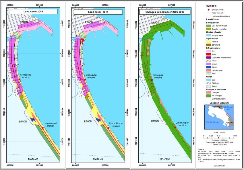
DOI: http://dx.doi.org/10.15359/ru.35-2.6
                                                                                                E-ISSN: 2215-3470
                                                                                                  CC: BY-NC-ND

    Resumen
    Investigaciones realizadas en los últimos años han advertido sobre los efectos que generan los cambios en
    línea de costa sobre el espacio costero en el caribe sur de Costa Rica. El objetivo de la presente investigación

                                                                                                                         UNICIENCIA Vol. 35, N°. 2, pp. 1-23. July-December, 2021 •
    es evaluar este efecto sobre las coberturas de la tierra en la costa del caribe sur de Costa Rica. La metodología
    empleada consiste en el levantamiento y comparación de las coberturas de la tierra en los años 2005 y
    2016 (con verificación en campo para el año 2017) en una franja costera de 200 m de ancho a partir de
    fotografías aéreas de gran escala por medio de algebra de mapas en ArcGis. Adicionalmente se establecen
    las coberturas afectadas por erosión costera determinada para los años 2005-2010 y 2010-2016, por medio
    de superposición de estas con las coberturas de la tierra del año 2005, permitiendo identificar qué áreas
    pasaron de ser playa a otro tipo de uso en los sectores de Cieneguita –Aeropuerto, Westfalia, Bananito,
    Cahuita– Puerto Vargas, Manzanillo y Sixaola. Los resultados obtenidos indican que en los segmentos
    Cieneguita–Aeropuerto, Westfalia, Bananito, Manzanillo y Sixaola– el principal cambio en las coberturas
    fue de playa por mar, con reajustes en otros tipos de coberturas, mientras que en Cahuita – Puerto Vargas
    el principal cambio fue de bosque a mar. En el segmento Cieneguita-Aeropuerto se presenta un aumento
    en la cobertura urbana, que eleva el riesgo por erosión costera, además de un aumento en la exposición de
    bienes de índole público. Se concluye que los efectos de la erosión costera ocurrida en puntos críticos en el
    Caribe Sur han inducido a cambios en las coberturas de la tierra, en su mayoría las playas, pasto y vegetación

                                                                                                                         www.revistas.una.ac.cr/uniciencia •
    costera son los más afectados al ser cambiados por superficies ocupadas por el mar, con excepción del
    Parque Nacional Cahuita donde de bosque de alta y baja densidad está retrocediendo frente al mar.
    Palabras clave: Cobertura de la tierra; Erosión costera; Línea de costa; Caribe sur; Costa Rica
    Resumo
    Pesquisas realizadas nos últimos anos advertiram sobre os efeitos geradores de mudanças na linha costeira
    sobre o espaço costeiro no Sul do caribe da Costa Rica. A presente pesquisa tem como objetivo avaliar este
    efeito sobre as coberturas terrestres na costa Sul do caribe deste país. A metodologia empregada consiste no
    levantamento e na comparação da cobertura terrestre em 2005 e 2016 (com verificação no terreno para o ano

                                                                                                                         revistauniciencia@una.cr
    de 2017) em uma faixa costeira de 200 m de largura a partir de fotografias aéreas de grande escala mediante
    a álgebra de mapas em ArcGis. Adicionalmente, são estabelecidas as coberturas afetadas pela erosão costeira
    determinada para os anos 2005-2010 e 2010-2016, por meio de sua sobreposição com as coberturas terrestre
    de 2005, permitindo identificar quais áreas passaram de ser praia a outro tipo de uso nos setores de Cieneguita–
    Aeroporto, Westfalia, Bananito, Cahuita– Puerto Vargas, Manzanillo e Sixaola. Os resultados obtidos indicam
    que nos segmentos Cieneguita–Aeroporto, Westfalia, Bananito, Manzanillo e Sixaola– a principal mudança
    na cobertura terrestre foi de praia a mar, com reajustes em outros tipos de coberturas, enquanto em Cahuita
    – Puerto Vargas, a principal mudança foi de floresta a mar. No segmento Cieneguita-Aeroporto apresenta um
    aumento na cobertura urbana, que eleva o risco por erosão costeira, além de um aumento na exposição de
    bens de índole público. Conclui-se que os efeitos da erosão costeira verificada em pontos críticos no Sul do
    caribe levaram a mudanças nas coberturas terrestres e, em maior parte, as praias, o pasto e a vegetação costeira
    são os mais afetados, sendo modificadas por superfícies ocupadas pelo mar, exceto o Parque Nacional Cahuita
    onde o bosque de alta e baixa densidade está retrocedendo em frente ao mar.
    Palavras-chave: cobertura terrestre; erosão costeira; linha costeira; Sul do caribe; Costa Rica

Luis Sandoval-Murillo • Gustavo Barrantes-Castillo                                                                   2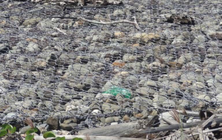
DOI: http://dx.doi.org/10.15359/ru.35-2.6
                                                                                    E-ISSN: 2215-3470
                                                                                      CC: BY-NC-ND

            INTRODUCTION                                    Coastal zones or littoral areas are a
                                                     strip resulting from the interaction between
          Coastal zones are areas with widely        nature and human activities influenced by
    varying socio-natural dynamics, where the        the sea (Barragan, 2003). These areas can

                                                                                                             UNICIENCIA Vol. 35, N°. 2, pp. 1-23. July-December, 2021 •
    characterization of land cover and its trans-    be broken down into biophysical, socio-
    formations over time give us information         economic and legal-administrative sub-
    about the socioeconomic activities that          systems, and present a series of particular
    take place in these spaces (Rujoiu-Mare          problems. From a biophysical perspective,
    & Mihai, 2016) as well as about the envi-        changes in the shoreline cause problems
    ronmental problems they present. It is im-       including loss of sediments from beaches,
    portant to establish the difference between      salinization of coastal wetlands, death of
    land cover and land use because, according       coastal vegetation, and sedimentation of
    to Mather (1986) and Pineda and Princi-          seagrasses and reefs. In the socioeconom-
    pi (2019), these terms are commonly con-         ic subsystem, changes in the coastline can
    fused. Land cover refers to the physical de-     affect residential use, increase sedimen-
    scription of the surface of the earth, which     tation in ports, modify fishing and tourist
    includes vegetation, areas without vegeta-       activities and transform the coastal land-
    tion and human zones; land use, for its part,    scape, among other effects. In terms of

                                                                                                             www.revistas.una.ac.cr/uniciencia •
    refers to the characterization of current hu-    the legal-administrative subsystem, it is
    man activities, focusing on socioeconomic        necessary to consider the content of Costa
    factors that modify, manage, preserve and        Rica’s Law 6043 on the Maritime Terres-
    use different types of land cover (Ramírez,      trial Zone, which establishes static limits
    2001; Richters, 1995).                           to an area that is undergoing strong trans-
          This distinction makes it possible to      formations, such as, retreating beaches,
    establish spatial relationships in different     which can lead to legal uncertainty about
    areas between the use and exploitation of        the granting of concessions in restricted
    coastal areas and natural transformations        areas. The southern Caribbean coastal area

                                                                                                             revistauniciencia@una.cr
    of the environment, which is the subject of      of Costa Rica has great natural wealth, in-
    the present study, which investigates land       cluding lagoons, estuaries, mangroves and
    cover and its changes in coastal erosion hot     coral reefs; likewise, coastal land has been
    spots in the southern Caribbean of Costa         occupied by ports, berths, and coastal com-
    Rica. Information on the relationship be-        munities, used for fishing and associated
    tween land cover and coastal erosive pro-        tourist services, and has many natural and
    cesses makes it possible to establish the        cultural resources; however, these areas
    degree of impacts on human activities as-        are also often characterized by significant
    sociated with the dynamics of changes in         lags in development and poverty. This par-
    land cover. These processes involve both         ticular combination of characteristics is the
    natural and social interactions, with so-        reason why the coastal area was selected as
    cial factors generating more accelerated         the subject of the present study.
    modifications over time, changing slightly              Together, factors such as the relative
    transformed environments into more artifi-       rise in mean sea level related to climate
    cial spaces.                                     change and local geodynamics (uplift or
                                                     subsidence of the land), as well as other

Luis Sandoval-Murillo • Gustavo Barrantes-Castillo                                                       3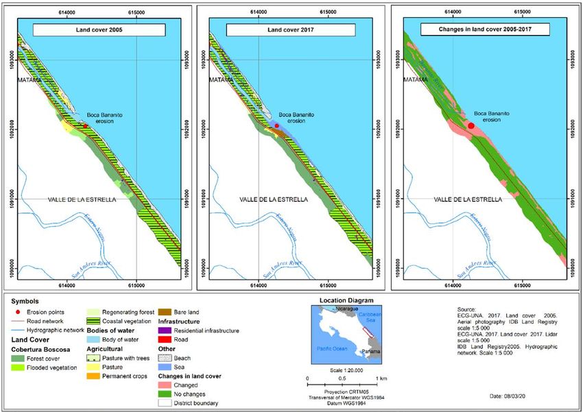
DOI: http://dx.doi.org/10.15359/ru.35-2.6
                                                                                    E-ISSN: 2215-3470
                                                                                      CC: BY-NC-ND

    causes more directly related to human ac-        affect each other; on the one hand, pro-
    tions, such as the filling of coastlines, con-   moting changes in land cover and, on the
    struction of infrastructure along the coast,     other hand, upsetting the balance of sedi-
    changes in drainage basins, and the con-         ments on sandy beaches.

                                                                                                             UNICIENCIA Vol. 35, N°. 2, pp. 1-23. July-December, 2021 •
    struction of dams can alter the sediment bal-           In the case of the Costa Rican south-
    ance necessary to maintain beaches (Posada       ern Caribbean coast, Lizano (2013) reports
    & Henao, 2008), leading to the erosion of        erosion processes on beaches in protect-
    sandy beaches.                                   ed areas and coastal tourist sites, which
           Changes in land cover are the result      strongly affect the Cahuita National Park,
    of a synergy between multiple endogenous         with land previously covered by forest be-
    and exogenous factors interacting at dif-        ing occupied by beaches or the sea (La Na-
    ferent levels, and are related to environ-       ción, 2010). This research is based on the
    mental, economic, population and public          work carried out by Barrantes, Arozarena,
    policy changes (Nene Preciado, González          Sandoval and Valverde (2020), which re-
    Sansón, Mendoza Cantú, & Silva Bátiz,            ported the existence of 11 coastal erosion
    2017). In the specific case of coastal areas,    hot spots (coastal sites where accelerated
    the interaction of natural and social compo-     erosion rates are registered) in the southern
    nents make this one of the most fragile en-      Caribbean. The present research aims to

                                                                                                             www.revistas.una.ac.cr/uniciencia •
    vironments in the terrestrial habitat, where     characterize land cover in these sites and its
    important transformations take place due         changes on the coast, to better understand
    to growth in road construction, residen-         the link between these two processes during
    tial infrastructure, and production systems      the 2005-2017 period.
    which promote coastal erosion processes.
    According to Silva et al., (2014), coastal             METHODOLOGY
    erosion is not a general problem in Latin
    America, but is widespread and may have                Study area
    serious effects in certain locations, affect-

                                                                                                             revistauniciencia@una.cr
    ing infrastructure in areas where natural               Costa Rica is a Central American
    uses previously predominated.                    country with coasts on the Pacific Ocean and
           These conditions are reflected in         the Caribbean Sea. The Caribbean coast has
    coastal areas, which are subject to con-         an approximate extension of 220 km, only
    tinuous increases in human activities that       one-fifth the length of the Pacific coast (Var-
    generate greater pressures and needs for         gas, 2006), due, on one hand, to the borders
    places to locate infrastructure, in some         established with Nicaragua to the north and
    cases in unsuitable areas. According to          Panama to the south, as well as a straighter
    Merlotto and Bértola (2008), as chang-           coast on the Caribbean side. The study area
    es and alteration in the natural environ-        is located in the province of Limón, running
    ment take place, the absorption capacity         from the city of Limón (to the south of the
    of the natural environment is reduced and        city’s urban center) to the mouth of the Six-
    pre-existing balances are altered. Identifi-     aola River (on the border with Panama). It
    cation of the processes of changes in land       is located between the following geographi-
    cover over time can be linked to the pro-        cal coordinates: -83.034864 W, -82.564229
    cesses of coastal erosion. These processes       W, 9.993417 N and 9.570096 N (Figure 1),

Luis Sandoval-Murillo • Gustavo Barrantes-Castillo                                                       4
DOI: http://dx.doi.org/10.15359/ru.35-2.6
E-ISSN: 2215-3470
CC: BY-NC-ND
UNICIENCIA Vol. 35, N°. 2, pp. 1-23. July-December, 2021 •
www.revistas.una.ac.cr/uniciencia •
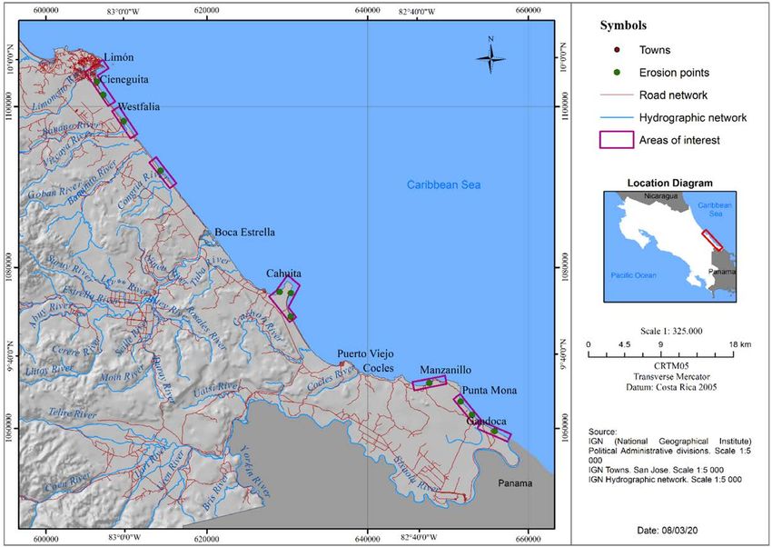
Figure 1. Location of the study area.
Generated during the investigation.
and covers the coastline of the districts of their nature, measured horizontally from the
Limón, Matina, Valle de la Estrella, Cahuita high tide line.”
revistauniciencia@una.cr
and Sixaola. It is important to highlight the The climate on the Caribbean coast
presence of protected areas in this region, does not have a defined dry season, but rath-
such as the Cahuita National Park, the Gan- er two periods in which rainfall decreases,
doca-Manzanillo Wildlife Refuge, and the the first from February to March and the
Keköldi Indigenous People’s Reserve, as second between September and October
well as the presence of the mouths of im- (IMN, 2017). Herrera (1986) classifies the
portant rivers such as the Banano, Estrella southern Caribbean climate as hot humid
and Sixaola. with a short dry season.
The study area encompasses a 200 m
wide strip along the coastline, which rough- Methodological process
ly coincides with the restricted area estab-
lished in Law 6043 on the Maritime Terres- To define the area to be studied, the
trial Zone defined as: “a two hundred meters critical points for coastal erosion identi-
wide strip along the entire Caribbean and fied in the southern Caribbean of Costa
Pacific coastlines of the Republic, whatever Rica during the 2005-2016 period were
used as a reference (Barrantes et al., 2020).
Luis Sandoval-Murillo • Gustavo Barrantes-Castillo 5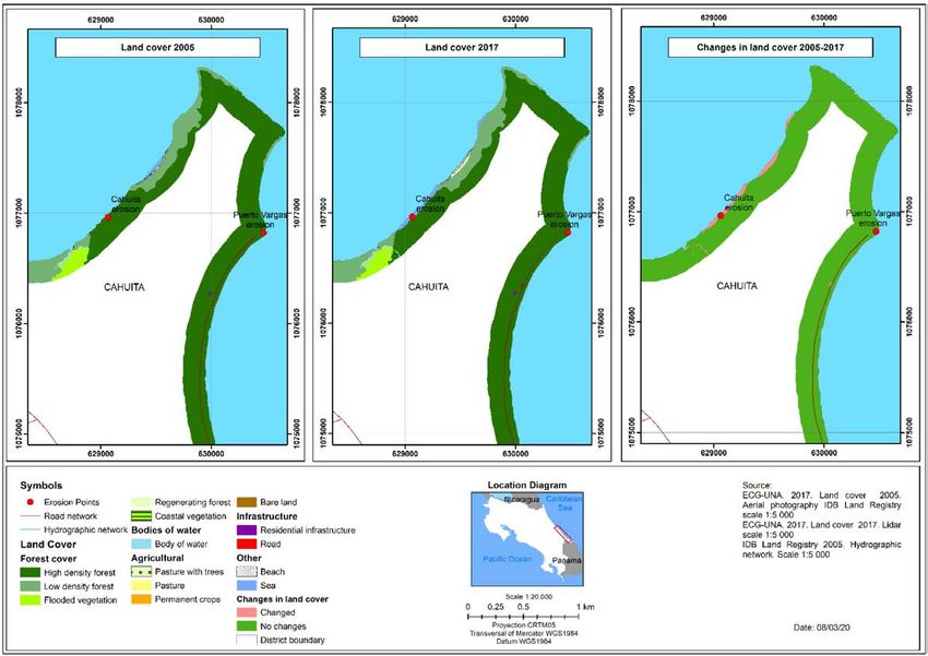
DOI: http://dx.doi.org/10.15359/ru.35-2.6
                                                                                                   E-ISSN: 2215-3470
                                                                                                     CC: BY-NC-ND

    According to these authors, the critical sites            defined from the orthophotos are presented
    are: a) Cieneguita, b) Airport, c) Wesfalia,              and defined in Table 1.
    d) Cahuita, e) Puerto Vargas, f) Manzanillo                      Since the purpose of this research is
    and g) Sixaola (Figure 1). For the genera-                to characterize changes in land cover in re-

                                                                                                                             UNICIENCIA Vol. 35, N°. 2, pp. 1-23. July-December, 2021 •
    tion of land cover layers in shapefile format,            lation to the erosive processes that were re-
    two sources of information were used: A                   corded, a work area of 200 m from the coast-
    mosaic of orthophotos for the year 2005 at a              line inland was defined, for the purpose of
    scale of 1: 5 000, with a spatial resolution of           temporal comparisons. For the purpose of
    0.5 m (from the BID-Cadastre project), and                generalizations, the coverage classes were
    orthophotos for the year 2016 at a scale of 1:            grouped into two categories: Natural (N)
    1 000, with spatial resolution of 0.1 m, that             and Non-natural (NN).
    belong to the National Emergencies Com-                          Photointerpretation and digitization
    mission (CNE). The information provided                   of the land cover categories were carried
    had already undergone orthorectification,                 out using ArcGIS software, with the attri-
    so the present study focused on the stages                bute table structured in terms of fields for
    of photointerpretation, digitization through              use and hectares for 2005 and 2017. These
    ArcGis software and field verification in                 data facilitated the creation of maps to nu-
    December 2017. The land cover categories                  merically calculate surfaces for each

                                                                                                                             www.revistas.una.ac.cr/uniciencia •
                                                              year.
                                    Table 1. Definition of land cover categories.
             General categories                                             Characterization
     High density forest                         Forest ecosystems characterized by an abundant canopy that limits
     (Natural)                                   light penetration in the herbaceous and shrub stratum, which show
                                                 only a limited presence of anthropic activity, are identified in the
                                                 images as areas with high canopy density.
     Low density forest                          Forests that show strong human intervention, followed by natural
     (Natural)                                   regeneration processes after the primary forest has been totally or
                                                 selectively eliminated by anthropic activities or natural events.

                                                                                                                             revistauniciencia@una.cr
     Regenerating forest                         Areas in the process of natural regeneration after the primary forest
     (Natural)                                   has been totally or selectively eliminated by anthropic activities or
                                                 natural events.
     Coastal vegetation                          Vegetation typical of the transition zone between an aquatic environ-
     (Natural)                                   ment and a terrestrial environment.
     Flooded vegetation                          Occurs in flat places where soils are saturated for several months of
     (Natural)                                   the year due to high rainfall.
     Body of water                               Surface covered by water both naturally and artificially.
     (Natural)
     Pasture                                     Partial removal (less than 50%) of trees and replacement by grass due
     (Not natural)                               to anthropic activities, especially extensive cattle ranching.
     Crops (Not natural)                         Areas with agricultural activities that can be permanent or seasonal.
     Urban - dispersed infrastructure            Characterized by urban-residential occupation, accompanied by insti-
     (not natural)                               tutional, industrial, commercial and recreational public services such
                                                 as plazas, as well as the presence of spatially dispersed residences.
     Beach (Natural)                             Area of accumulation of sand and other sediments in seas, rivers and
                                                 lakes, with a flat surface or with a slight slope.
     Sea (Natural)                               Mass of salty water that covers part of the earth’s surface.
    Source: Adapted from Morera and Sandoval (2013).

Luis Sandoval-Murillo • Gustavo Barrantes-Castillo                                                                       6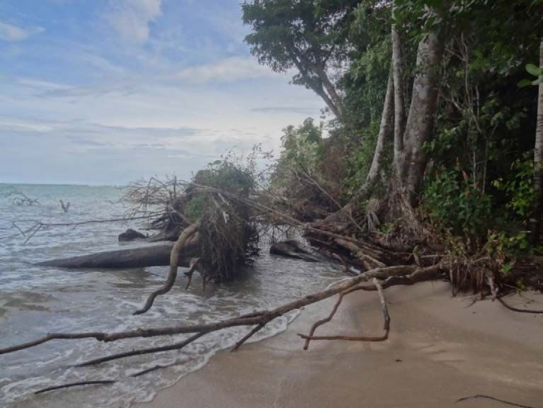
DOI: http://dx.doi.org/10.15359/ru.35-2.6
                                                                                                   E-ISSN: 2215-3470
                                                                                                     CC: BY-NC-ND

                                          Table 2. Land cover change matrix
      Categories      Year 2016        C1            C2    C3      C4          C5           C6            C7            C8
      Year 2005        Weight          100           200   300     400         500          600           700           800
         C1               1            101           201   301     401         501          601           701           801

                                                                                                                                  UNICIENCIA Vol. 35, N°. 2, pp. 1-23. July-December, 2021 •
         C2               2            102           202   302     402         502          602           702           802
         C3               3            103           203   303     403         503          603           703           803
         C4               4            104           204   304     404         504          604           704           804
         C5               5            105           205   305     405         505          605           705           805
         C6               6            106           206   306     406         506          606           706           806
         C7               7            107           207   307     407         507          607           707           807
         C8               8            108           208   308     408         508          608           708           808

     No change                                                   Changes
     Abbreviations
     C 1 = Flooded vegetation                                    C5 = Body of water
     C 2 = Coastal vegetation                                    C 6 = Pasture
     C 3 = Low density forest                                    C 7= Crops
     C 4 = Beach                                                 C 8 = Residential infrastructure

                                                                                                                                  www.revistas.una.ac.cr/uniciencia •
    Note: Generated during the investigation.

    Changes in land cover between 2005 and                                RESULTS
    2017 were represented based on the as-
    signment of weights or codes (Table 2),                               Land cover in the southern Carib-
    which allowed their differentiation and                               bean of Costa Rica 2005 – 2017
    facilitated recording the changes that oc-
    curred through time. For example: a cate-                             Cieneguita–Airport Sector
    gory for the use of flooded vegetation for                          In the Cieneguita-Airport sector, nat-

                                                                                                                                  revistauniciencia@una.cr
    the year 2005 was assigned a value of 1                       ural cover in 2005 consisted of: low density
    and a value of 600 was assigned to the cat-                   forest (21 ha), coastal vegetation (2.41 ha),
    egory of use of pasture for the year 2017.                    body of water (1.45 ha), sea (0.18 ha) and
    When a change of use occurred involving                       beach (16.25 ha). An analysis shows sig-
    these two categories, an algebraic sum of                     nificant changes in the surface areas of the
    maps was calculated (adding the tables of                     beach and sea categories, with total beach
    both layers), and the result was 601 (Table                   area decreasing by 1.84 ha and the total area
    2), which indicates that an area was pre-                     of the sea increasing by 1.76 ha. From these
    viously categorized as flooded vegetation,                    data it is possible to conclude that most of
    but later became covered with grass.                          the beach loss is related to an advance of the
                                                                  sea towards land (Figure 3 and Graph 1).
                                                                        In 2005, there was 117 ha (74%) of
                                                                  land classified as “not natural,” where hu-
                                                                  man activities were include; the total area
                                                                  of not natural land had increased by 0.29
                                                                  ha in the year 2017, an increase related

Luis Sandoval-Murillo • Gustavo Barrantes-Castillo                                                                            7
DOI: http://dx.doi.org/10.15359/ru.35-2.6
                                                                                              E-ISSN: 2215-3470
                                                                                                CC: BY-NC-ND

    to recreational spaces such as parks and                 of mitigation measures to protect the ex-
    courts (1.72 ha), residences (0.17 ha) and               posed works (Figure 2), as well as the place-
    roads (1.3 ha) on land previously occupied               ment of a stone dam to protect the Cienegui-
    by beaches. This change in land cover was                ta bike path.

                                                                                                                       UNICIENCIA Vol. 35, N°. 2, pp. 1-23. July-December, 2021 •
    the result of an attempt to reactivate the
    area economically, with an investment of                        Westfalia sector
    around 2 million dollars for the construc-                      The sector of Westfalia has an area of
    tion of a boulevard, small plazas, a bicycle             96 ha; 69 ha (70%) of this area had natural
    lane, playing fields and areas for children’s            cover in the year 2005 which increased to
    games by the central government (Mora,                   74 ha (77%) for the year 2017. The natural
    2015). However, these works, as well as                  categories that had decreased in area in 2017
    houses facing the sea, were being affected               were low density forest (by 1.3 ha), flooded
    by severe waves just one year after their in-            vegetation (by 0.5 ha) and especially beach-
    auguration (Bosque, 2016a).                              es (by 7 ha) (Graph 2); on the other hand,
           From the data provided by Barrantes               coastal vegetation (by 0.1 ha), regenerating
    et al. (2020) it is estimated that the erosion           forest (by 2.6 ha), bodies of water (by 3.2 ha)
    rate in this sector for the 2005 – 2016 period           and the sea (by 7.7 ha) increased in area. In
    was 0.39 ha / year, which is reflected in the            this sector, the beach seems once again to be

                                                                                                                       www.revistas.una.ac.cr/uniciencia •
    data presented here and in the construction

                                                                                                                       revistauniciencia@una.cr

    Graph 1. Cieneguita–Airport Sector: Land cover 2005 – 2017 period.
    Source: Prepared by the authors based on land cover data 2005 - 2017, generated during the investigation.

Luis Sandoval-Murillo • Gustavo Barrantes-Castillo                                                                 8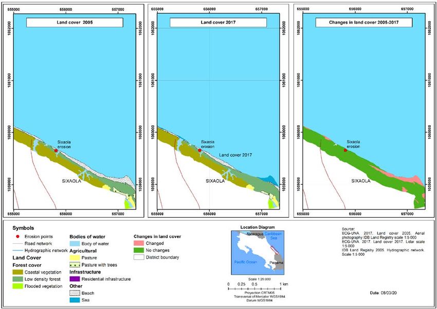
DOI: http://dx.doi.org/10.15359/ru.35-2.6
                                                                                        E-ISSN: 2215-3470
                                                                                          CC: BY-NC-ND

    being replaced mainly by the sea
    (5.7 ha), but several other types
    of land cover also increased in
    total area, including regenerat-

                                                                                                                 UNICIENCIA Vol. 35, N°. 2, pp. 1-23. July-December, 2021 •
    ing forest (2.6 ha), coastal veg-
    etation (0.04 ha), bare land 0.07
    (ha) and pasture (0.04 ha).
          In the case of non-natural
    types of land cover, there was
    an increase in permanent crops,
    going from 1.6 ha (2005) to 2.7
    ha in the year 2017, while res-
    idential infrastructure, which
    covered an area of 1.9 ha in the Figure 2. Airport Sector: Installation of gabions.
                                         Taken in the field on December 6, 2017.
    year 2005 and 2.8 ha in the year
    2017. However, it is important to highlight the
                                                          (figure 4). This retreat of pastures and beach-
    pasture reduction by 6.7 ha during the study
                                                          es is in accordance with what was reported by
    period, which primarily changed to the sea
                                                          Barrantes et al. (2018); from their data, the

                                                                                                                 www.revistas.una.ac.cr/uniciencia •
                                                                                                                 revistauniciencia@una.cr

    Figure 3. Cieneguita-Airport Sector: Land cover and changes during the 2005 – 2017 period.
    Generated during the investigation.

Luis Sandoval-Murillo • Gustavo Barrantes-Castillo                                                           9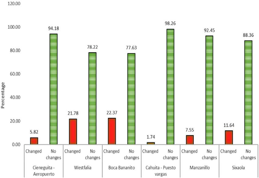
DOI: http://dx.doi.org/10.15359/ru.35-2.6
                                                                                               E-ISSN: 2215-3470
                                                                                                 CC: BY-NC-ND

                                                                                                                         UNICIENCIA Vol. 35, N°. 2, pp. 1-23. July-December, 2021 •
                                                                                                                         www.revistas.una.ac.cr/uniciencia •
    Gráfica 2. Sector Westfalia: Cobertura de la tierra periodo 2005 – 2017
    Nota: Elaboración propia a partir de la cobertura de la tierra año 2005 - 2017, generado en la investigación.

    erosion rate in the sector is estimated at 0.56           In the case of the beach category, its area
    ha / year, higher than in the case of Cienegui-           decreased by 5% (5 ha), a change which
    ta-Aeropuerto, which according to these same              was associated with the dynamics of the

                                                                                                                         revistauniciencia@una.cr
    authors is due to the migration of the mouth              mouth of the Bananito River. With regard
    of the Banano River during the study period.              to anthropic activities, there was a slight
                                                              increase in residential infrastructure, from
            Bananito sector                                   0.3 ha in 2005 to 0.6 ha in 2017, while
                                                              the area covered by road infrastructure re-
          For natural land cover in the Banani-               mained constant (Graph 3).
    to sector in the year 2005, coastal vegeta-                     According to Barrantes et al. (2020),
    tion cover predominated with a total area                 changes in the mouth of the Banano Riv-
    of 49.8 ha, followed by low-density forest                er are important in this sector, since the
    (16.3 ha), and beaches with 13 ha (Graph                  direction of coastal currents in the Ca-
    3). All natural surfaces showed a reduc-                  ribbean (Lizano, 2018) caused erosion of
    tion during the study period except for                   the left bank of the river mouth and accu-
    low-density forest, which increased from                  mulation of sediments on the right bank,
    16.3 ha in 2005 to 22.5 ha in 2017, with                  leading to the reinforcement of the road
    the increase occurring mainly behind the                  to prevent its destruction. As a result of
    coastal road (towards the land) (Figure 6).               these changes, coastal vegetation, bare

Luis Sandoval-Murillo • Gustavo Barrantes-Castillo                                                                  10
DOI: http://dx.doi.org/10.15359/ru.35-2.6
E-ISSN: 2215-3470
CC: BY-NC-ND
UNICIENCIA Vol. 35, N°. 2, pp. 1-23. July-December, 2021 •
www.revistas.una.ac.cr/uniciencia •
Figure 4. Westfalia Sector: Land cover and changes during the 2005 – 2017 period.
Generated during the investigation.
revistauniciencia@una.cr
Graph 3. Bananito Sector: Land cover during the 2005 – 2017 period.
Source: Prepared by the authors based on land cover data during the 2005 – 2017 period. generated during the
investigation.
Luis Sandoval-Murillo • Gustavo Barrantes-Castillo 11DOI: http://dx.doi.org/10.15359/ru.35-2.6
E-ISSN: 2215-3470
CC: BY-NC-ND
land and beaches decreased in area as the Cahuita Sector-Puerto Vargas
area covered by sea increased (Figure 6).
Land cover for the Cahuita-Puerto
However, beaches also decreased in area
Vargas sector is characterized by the pre-
as a result of increases in the coastal veg-
UNICIENCIA Vol. 35, N°. 2, pp. 1-23. July-December, 2021 •
dominance of natural cover throughout the
etation that grows on the sandy bar north
study area. As can be seen in Graph 4, the
of the river mouth (Figure 5).
area covered by high-density forest de-
creased by 1.4 ha during the study period,
while the area covered by low-density forest
Cieneguita Cieneguita Wesfalía 2005 Westfalía 2016 Boca Bananito Boca Bananito
2005 2016 2005 2016
www.revistas.una.ac.cr/uniciencia •
revistauniciencia@una.cr
Figure 5. Changes in land cover according to aerial photography 2005 - 2016.
Made from a mosaic of orthophotos from 2005 at a scale of 1: 5 000, with a spatial resolution of 0.5 meters
(from the National Registry), 2) Orthophotos from 2016 at 1: 1 000 scale, with a spatial resolution of 0.1 m
(property of the National Emergency Commission (CNE)).
Luis Sandoval-Murillo • Gustavo Barrantes-Castillo 12DOI: http://dx.doi.org/10.15359/ru.35-2.6
E-ISSN: 2215-3470
CC: BY-NC-ND
UNICIENCIA Vol. 35, N°. 2, pp. 1-23. July-December, 2021 •
www.revistas.una.ac.cr/uniciencia •
Figure 6. Bananito Sector: Land cover and changes during the 2005 – 2017 period.
Generated during the investigation.
decreased by 0.5 ha. Most of
the decrease in high-density
revistauniciencia@una.cr
forest is due to increases in
the area covered by the sea,
showing an accelerated re-
treat of the shoreline in this
sector (Barrantes et al., 2018)
(Figure 7). On the other hand,
there was a slight increase in
the area occupied by beaches
(in 0.1 ha) which, according to
Barrantes et al. (2018) is the
result of the accretion (growth
of beaches and other forms
of coastal accumulation) of a
small segment of beach locat- Figure 7. Cahuita-Puerto Vargas Sector: Forest cover
ed to the northeast of the point affected by coastal erosion.
of greatest erosion (Figure 8). Taken in the field on December 6, 2017.
Luis Sandoval-Murillo • Gustavo Barrantes-Castillo 13DOI: http://dx.doi.org/10.15359/ru.35-2.6
E-ISSN: 2215-3470
CC: BY-NC-ND
As can be seen in Graph 4, the area of natural cover: 85.6 ha in the year 2005
residential infrastructure increased slightly, and 86.4 ha in the year 2017. As shown in
going from 0.084 ha to 0.129 ha. It is import- Graph 5, there was a significant increase in
ant to emphasize the impact of severe waves the area occupied by the sea at the expense
UNICIENCIA Vol. 35, N°. 2, pp. 1-22. July-December, 2021 •
on infrastructure, which led the park admin- of areas of low-density forest (0.08 ha), ar-
istration to relocate its house and office, as eas of natural regeneration (0.04 ha), and,
can be seen in the remains left where the old most notably, beaches (4.2 ha). The area
building was located; likewise, sections of covered by beaches shows a significant
the trail within the park disappeared, which decrease between 2005 and 2017, going
led to its relocation (Soto, 2014). Accord- from 5.8 ha to 1.5 ha, as the area covered
ing to the data presented by Barrantes et al. by the sea increased substantially (4.1 ha),
(2020), the average erosion rate in the sec- and the area covered by coastal vegetation
tor is estimated to be 0.46 ha / year, a figure increased slightly (0.29 ha) (Figure 9).
that is considered intense. An average erosion rate for this sector of
0.12 ha / year was estimated based on the
Manzanillo sector data presented by (Barrantes et al. 2020),
which is considered to be mild, due to the
The distribution of land cover in size of the sector.
Manzanillo shows a predominance of
www.revistas.una.ac.cr/uniciencia •
revistauniciencia@una.cr
Figure 8. Cahuita-Puerto Vargas Sector: Land cover and changes during the 2005 – 2017 period.
Generated during the investigation.
Luis Sandoval-Murillo • Gustavo Barrantes-Castillo 14DOI: http://dx.doi.org/10.15359/ru.35-2.6
E-ISSN: 2215-3470
CC: BY-NC-ND
UNICIENCIA Vol. 35, N°. 2, pp. 1-23. July-December, 2021 •
www.revistas.una.ac.cr/uniciencia •
Graph 4. Cahuita-Puerto Vargas Sector: Land cover during the 2005 – 2017 period.
Source: Prepared by the authors based on land cover data during the 2005 – 2017 period, generated during the
investigation.
revistauniciencia@una.cr
Graph 5. Manzanillo Sector: Land cover during the 2005 – 2017 period.
Source: Prepared by the authors based on land cover data during the 2005 – 2017 period, generated during the
investigation.
Luis Sandoval-Murillo • Gustavo Barrantes-Castillo 15DOI: http://dx.doi.org/10.15359/ru.35-2.6
E-ISSN: 2215-3470
CC: BY-NC-ND
In the case of anthropic coverage, a of the area covered by beaches between
slight increase in residential infrastructure 2005 and 2017, to 6.9 ha (Graph 6). This
was observed, from 0.2 ha in the year 2005 reduction in the surface is associated with
to 0.3 ha for the year 2017, together with an increase in the area of the covers such
UNICIENCIA Vol. 35, N°. 2, pp. 1-23. July-December, 2021 •
a reduction in the area covered by pasture as sea (5.2 ha) and low-density forest (3.8
which was 4.6 ha in 2005 and 3.9 ha in 2017 ha) (Figure 10). The rest of the covers
(Graph 6), which contributed to the increase showed little change.
in area covered by low-density forest and It is important to note that a significant
residential infrastructure. part of the loss of beach cover is related to
the disappearance of the accumulated sand
Sixaola sector bank on the Costa Rican bank of the Six-
aola River. This bank is possibly composed
Barrantes et al. (2020) identified of beach ridges characteristic of a previous
three hot spots of erosion in Gandoca, one process of progradation (growth towards
of them near the mouth of the Sixaola riv- the sea of a delta or coastal plain) of this
er. When comparing changes in land cov- important river system.
er, there is evidence of a marked decrease
www.revistas.una.ac.cr/uniciencia •
revistauniciencia@una.cr
Figure 9. Manzanillo Sector: Land cover and changes during the 2005 – 2017 period.
Generated during the investigation.
Luis Sandoval-Murillo • Gustavo Barrantes-Castillo 16DOI: http://dx.doi.org/10.15359/ru.35-2.6
E-ISSN: 2215-3470
CC: BY-NC-ND
UNICIENCIA Vol. 35, N°. 2, pp. 1-23. July-December, 2021 •
www.revistas.una.ac.cr/uniciencia •
Graph 6. Sixaola Sector: Land cover during the 2005 – 2017 period.
Source: Prepared by the authors based on land cover data during the 2005 – 2017 period, generated during the
investigation.
revistauniciencia@una.cr
Figure 10. Sixaola Sector: Land cover and changes during the 2005 – 2017 period.
Generated during the investigation.
Luis Sandoval-Murillo • Gustavo Barrantes-Castillo 17DOI: http://dx.doi.org/10.15359/ru.35-2.6
E-ISSN: 2215-3470
CC: BY-NC-ND
DISCUSSION OF RESULTS In second place, images suggest that
the Sixaola sector experienced a change in
In general terms, based on the anal- morphodynamic behavior from progradation
ysis carried out in each sector (Graph 7), it to erosion of the sand banks that are located
UNICIENCIA Vol. 35, N°. 2, pp. 1-23. July-December, 2021 •
is clear that the largest changes in land cov- on the sides of the river mouth, and increas-
er occur at the mouth of the Bananito Riv- es between 2005 – 2017 in areas covered by
er and in Westfalia. When comparing the the sea, resulting in a reduction of beaches
2005 land cover map with the areas eroded by 2.29 ha, coastal vegetation by 1.92 ha
between 2005-2016, reported by Barrantes and low-density forest by 3.09 ha (Graph 8).
et al. (2020), it was found that areas in the When comparing areas that were affected by
Bananito sector, surfaces mainly associated erosion processes between 2005 and 2016,
with coastal vegetation (3.49 ha), beaches there is evidence of a greater impact on the
(0.99 ha) (which formed part of sand bars) natural covers that are part of the pioneer veg-
and grass (0.01 ha) and residential infra- etation that populates these environments.
structure (0.03 ha) were lost (Graph 8), Next, Manzanillo is protected from
while in Westfalia mainly coastal vegetation the direct impact of waves by the presence
(2.65 ha), grass (2.97 ha), forest (0.95 ha) of a reef, but there was a significant loss of
and beach (0.26 ha) were lost. beach in a small sector. As shown in Graph
www.revistas.una.ac.cr/uniciencia •
revistauniciencia@una.cr
Graph 7. Changes in land cover by erosion sectors South Caribbean, period 2005-2017.
Source: Prepared by the authors based on land cover data during the 2005 – 2017 period. Generated during the
investigation.
Luis Sandoval-Murillo • Gustavo Barrantes-Castillo 18DOI: http://dx.doi.org/10.15359/ru.35-2.6
E-ISSN: 2215-3470
CC: BY-NC-ND
8, 0.23 ha of beach was lost to erosion be- advance of the sea over beaches of between
tween 2005 and 2016, which also affected 30 and 60 meters between 2014 and 2015.
1.08 ha of coastal vegetation and 1.42 ha of These facts highlight the level of risk of the
low-density forest. infrastructure developed in this sector in
UNICIENCIA Vol. 35, N°. 2, pp. 1-23. July-December, 2021 •
In the penultimate position is the the face of coastal erosion that removes the
Cieneguita-Airport sector. According to sand from its foundations and, on occasions,
Barrantes et al. (2018), the most likely cause floods the new boulevard (Arguedas, 2017)
of changes in land cover in this sector is the due to severe waves or extraordinary tides.
existence of a breakwater located in Ciene- Finally, Cahuita shows the least
guita beach that retains sediments from the change during the period studied, although
Limoncito river. In this sector, decreases it is pronounced in small forested areas
natural covers such as beaches (0.05 ha) which recede in front of the sea, which can
have occurred. In addition, when comparing be seen by comparing the land cover for the
the land cover in 2005 with the coastal ero- year 2005 with the study by Barrantes et al.
sion that occurred between 2005 and 2016, (2020) on critical beaches in terms of coast-
a direct impact on decreases in the areas of al erosion in 2005 and 2016, in which the
cover types such as residences (0.01 ha), main coverage affected by these processes
runway (0.08 ha) and pastures (5.14 ha) can was found to be forest, which lost 8.52 ha.
www.revistas.una.ac.cr/uniciencia •
be detected. According to Bosque (2016b), In Manzanillo, the areas with the
the community was affected by a landward greatest decreases in area are protected
revistauniciencia@una.cr
Graph 8. Land cover in 2005 affected by erosion between 2005 and 2016.
Note: N: Natural; NN: Not natural. Prepared by the authors based on other mosaics from 2005 and 2016, upda-
ted with field work in 2017.
Luis Sandoval-Murillo • Gustavo Barrantes-Castillo 19DOI: http://dx.doi.org/10.15359/ru.35-2.6
E-ISSN: 2215-3470
CC: BY-NC-ND
from direct waves by a reef (Barrantes et. beaches, grasses and coastal vegetation in
al., 2018). However, according to the news- favor of the sea has taken place as the sea
paper article by Soto (2014), in the last 15 encroaches on the land.
years the Cahuita National Park lost 20 In Westfalia, pastures which were
UNICIENCIA Vol. 35, N°. 2, pp. 1-23. July-December, 2021 •
meters of beach due to coastal erosion, a close to the beach and the beaches them-
situation that directly affects species such selves lost the greatest areas to the ad-
as turtles (Baula, Verde and Carey) which vancing sea, followed by low-density for-
find less space for egg laying, and decreases est. However, the areas of some types of
camping space for tourists due to the retreat cover such as regenerating forest, coastal
and decrease in the width of the beaches. vegetation and bare land, are increasing
The above findings are consistent with as a result of the silting up of parts of the
those of Luijendijk et al. (2018) who ana- old river mouth.
lyzed erosion of sandy beaches around the In Bananito, the greatest changes in
world and found that most sandy coastlines coverage were decreased areas of beach and
in protected areas are being eroded. This sit- coastal vegetation balanced by increased ar-
uation was also evident in the southern Ca- eas covered by the sea, and land denuded by
ribbean of Costa Rica, where its two marine the action of waves on the coast. Likewise,
protected areas showed significant processes part of the regenerating vegetation on the
www.revistas.una.ac.cr/uniciencia •
of retreat of the shoreline, affecting the re- sand bar that is growing at the river mouth
sources and services that these areas offer for is coastal vegetation.
the livelihood of local communities. In the Cahuita sector there has been
a loss of high-density forest (which is not
CONCLUSIONS coastal vegetation) and a small area of
low-density forest which has been replaced
In the southern Caribbean of Costa by the sea, as well as an increase in regen-
Rica there are areas with accelerated coast- erating forest and a small area of beach
al erosion, or “erosion hotspots,” in which where the coastline is advancing towards
revistauniciencia@una.cr
landscape transformations have taken place the sea (accretion). Regarding human use,
that can be evaluated in terms of changes there is a slight increase in residential in-
in land covert. In the case of natural cover, frastructure which has been affected by
erosion reported in these areas has caused erosive processes that led to the relocation
losses of beaches, grasslands and coastal of trails and other infrastructure for tourist
vegetation, and even of forest, while the activity, leaving behind indications of their
area covered by the sea has increased, like- previous locations.
wise effects on urban covert have been re- In the Manzanillo sector, the main
ported in Cieneguita and Manzanillo. change in coverage has been the loss of
Changes in land cover for the Ciene- beaches to the sea, leading to an effort to
guita-Airport sector indicate an increase in increase the coverage of coastal vegetation
urban coverage related to the construction on the coastline to protect the town from
of a boulevard and recreational infrastruc- severe waves. Likewise, there has been a
ture. These uses have increased the risk of slight increase in residential infrastructure,
coastal erosion and loss of public goods. a process that increases risks in the sector.
Once again, a loss of natural covers such as
Luis Sandoval-Murillo • Gustavo Barrantes-Castillo 20DOI: http://dx.doi.org/10.15359/ru.35-2.6
E-ISSN: 2215-3470
CC: BY-NC-ND
The sector at the mouth of the Six- DECLARATION OF DATA
aola River experienced a strong decrease in AVAILABILITY
the area of beaches, and to a lesser degree
of pasture with trees. In the first case this The data supporting the results of this
UNICIENCIA Vol. 35, N°. 2, pp. 1-23. July-December, 2021 •
was due to the reduction of sandbanks on study will be made available by the corre-
the right bank of the river and in the second sponding authors [L.S.M. and G.B.C.] upon
case the change was due to an increase in reasonable request.
low-density forest vegetation.
The effects of coastal erosion that REFERENCES
occurred between 2005 and 2016, report-
ed for critical points of coastal erosion Arguedas, D. (March 20, 2017). Cieneguita teme
in the southern Caribbean of Costa Rica, que el mar le robe su nuevo rostro [Ciene-
have produced changes in land cover. For guita fears that the sea will steal its new
the most part, beaches, pasture and coast- face]. Agencia de Noticias Inter Press Servi-
ce (IPS). http://www.ipsnoticias.net/2017/03/
al vegetation are the type of land cover comunidad-en-costa-rica-teme-que-el-mar-
most affected by encroachment of the sea. le-robe-su-nuevo-rostro/
In the particular case of Punta Cahuita, Barragán, J. (2003). Medio ambiente y desarrollo
high- and low-density forest vegetation is en las áreas litorales [Environment and de-
velopment in coastal areas]. Universidad de
www.revistas.una.ac.cr/uniciencia •
retreating in front of the sea despite being
Cádiz, Servicio de publicaciones.
sheltered by a coral reef and being within Barrantes, G., Valverde, J. F., Piedra, L., Quesada,
a protected area. A., Castillo, M. & Sandoval, L. (2018). Cam-
bios en la línea de costa en playa Cienegui-
ACKNOWLEDGMENTS ta [Changes in the coastline at Cieneguita
beach, Limón]. In F. Diehl (Presidencia), 17º
Congresso Latino-Americano de Ciências do
This work was undertaken within the Mar (pp. 1212-1214). Balneário Camboriú,
framework of the research project: Project Brasil: Associação Latino-Americana de Pes-
SIA 0096-15: Coastal erosion in the South quisadores em Ciências do Mar.
revistauniciencia@una.cr
Caribbean of Costa Rica: Ecosystem impact Barrantes-Castillo, G., Arozarena-Llopis, I., San-
doval-Murillo, L. F., & Valverde-Calderón,
and social vulnerability, which was carried J. F. (2020). Critical beaches due to coastal
out between 2016 and 2019. erosion in the Caribbean south of Costa Rica,
during the period 2005-2016. Revista Geo-
STATEMENT OF AUTHORS’ gráfica de América Central, 1(64), 123-150.
https://doi.org/10.15359/rgac.64-1.5
CONTRIBUTIONS Bosque, D. (February 14, 2016a). Ministerio de
Vivienda construyó millonario parque en
The total percentage of contribution zona de riesgo [The Ministry of Housing
for the conceptualization, preparation and built a millionaire park in a risk area]. La
nación. https://www.nacion.com/el-pais/in-
editing of this article was as follows: L.S.M. fraestructura/ministerio-de-vivienda-cons-
50%; G.B.C. 50%. truyo-millonario-parque-en-zona-de-riesgo/
RSWSVN3X3FBABMEYALS7NJ4SOM/
story/
Bosque, D. (February 14, 2016b). Mar se come
poco a poco el barrio Cieneguita en Limón
[The sea slowly devours the Cieneguita
Luis Sandoval-Murillo • Gustavo Barrantes-Castillo 21DOI: http://dx.doi.org/10.15359/ru.35-2.6
E-ISSN: 2215-3470
CC: BY-NC-ND
neighborhood in Limón]. La Nación. https:// erosion in the Parque Mar Chiquita resort,
www.nacion.com/el-pais/mar-se-come-po- Argentina]. Papeles De Geografía, 47-48,
co-a-poco-el-barrio-cieneguita-en-limon/ 143-158. https://revistas.um.es/geografia/
4QQBEPJUDVH6DDPKXSE3HSE6UI/ article/view/41271
story/ Mora, C. (March 7, 2015). Cieneguita, barrio li-
UNICIENCIA Vol. 35, N°. 2, pp. 1-23. July-December, 2021 •
Herrera, W. (1986). Clima de Costa Rica: Vege- monense, estrena nuevas canchas depor-
tación y clima de Costa Rica [Climate of tivas, parques y una ciclovía [Cienegui-
Costa Rica: Vegetation and climate of Costa ta, a neighborhood in Limon, opens new
Rica]. EUNED. sports fields, parks and a bike path]. crhoy.
Instituto Meteorológico Nacional (IMN). (2017). com. https://archivo.crhoy.com/cienegui-
Clima de Costa Rica: El clima y las regio- ta-barrio-limonense-estrena-nuevas-can-
nes climáticas de Costa Rica [Climate of chas-deportivas-parques-y-una-ciclovia/
Costa Rica: The climate and climatic re- nacionales/
gions of Costa Rica]. Instituto Meteoroló- Morera, C. & Sandoval, L. (2013). Los procesos de
gico Nacional. https://www.imn.ac.cr/docu- fragmentación y la conectividad forestal en
ments/10179/31165/clima-regiones-climat. Costa Rica: Dos casos de estudios [Fragmen-
pdf/cb3b55c3-f358-495a-b66c-90e677e35f57 tation processes and forest connectivity in
La Nación. (November 10, 2010). Erosión en las Costa Rica: Two case studies]. In Geografia,
playas de Costa Rica: Urge tomar medi- Paisaje y Conservación. ECG - UNA.
das en la zona marítimo-terrestre debido al Nene Preciado, A., González Sansón, G., Mendoza
cambio climático [Erosion on the beaches Cantú, M., & Silva Bátiz, F. (2017). Cambio
of Costa Rica: It is urgent to take measu- de cobertura y uso de suelo en cuencas tropi-
www.revistas.una.ac.cr/uniciencia •
res in the maritime-terrestrial zone due to cales costeras del Pacifico Central Mexicano
climate change]. https://www.nacion.com/ [Cover change and land use in tropical coas-
archivo/erosion-en-las-playas-de-costa-rica/ tal basins of the Central Mexican Pacific]. In-
OGE2TL4PL5GD5LSTGORQ5I37J4/story/ vestigaciones Geográficas, 94. http://dx.doi.
Ley N° 6043. Sistema Costarricense de Información org/10.14350/rig.56770
Jurídica, San José, Costa Rica [Law 6043. Pineda, N. & Principi, N. (2019). Análisis espacial
Costa Rican Legal Information System], de cambios de usos del suelo con sistemas de
March 2nd, 1977. información geográfica [Spatial analysis of
Lizano, O. (2018). La dinámica de las corrientes changes in land use with geographic infor-
marinas frente al Caribe de Costa Rica [The mation systems]. In G. Buzai et al. (comp.),
revistauniciencia@una.cr
dynamics of ocean currents off the Caribbean Teoría y métodos de la geográfia cuantitati-
coast of Costa Rica]. Ambientico, 265, 6-12. va. Libro 2: Por una geográfia empírica (pp.
http://www.ambientico.una.ac.cr/pdfs/art/ 75-95). Instituto de Investigaciones Geográ-
ambientico/265-6-12.pdf ficas Universidad Nacional de Luján. http://
Lizano, O. G. (2013). Erosión en las playas de Cos- www.inigeo.unlu.edu.ar/?q=node/24
ta Rica, incluyendo la Isla del Coco [Erosion Posada, B. O. & Henao, W. (2008). Diagnóstico de
on the beaches of Costa Rica, including Co- la erosión en la zona costera del Caribe co-
cos Island]. InterSedes, 14(27). https://re- lombiano [Diagnosis of erosion in the coastal
vistas.ucr.ac.cr/index.php/intersedes/article/ zone of the Colombian Caribbean]. Editorial
view/10405 Ediprint. http://www.invemar.org.co/redcos-
Luijendijk, A., Hagenaars, G., Ranasinghe, R., Baart, tera1/invemar/docs/605220080501_AEro-
F., Donchyts, G., & Aarninkhof, S. (2018). sionCaribeContinentalColombia.pdf
The State of the World’s Beaches. Scientific Ramírez, Isabel. (2001). Cambios en las cubiertas
Reports, 8(1), 6641. https://doi.org/10.1038/ del suelo en la Sierra de Angangueo, Mi-
s41598-018-24630-6 choacán y Estado de México, 1971-1994-
Mather, A. S. (1986). Land use. Longman. 2000 [Changes in land cover in the Sierra
Merlotto, A., & Bértola, G. R. (2008). Evolución ur- de Angangueo, Michoacán and the State of
bana y su influencia en la erosión costera en Mexico, 1971-1994-2000]. Investigaciones
el balneario Parque Mar Chiquita, Argentina geográficas, 45, 39-55. http://www.scielo.
[Urban evolution and its influence on coastal
Luis Sandoval-Murillo • Gustavo Barrantes-Castillo 22DOI: http://dx.doi.org/10.15359/ru.35-2.6
E-ISSN: 2215-3470
CC: BY-NC-ND
org.mx/scielo.php?script=sci_arttext&pi- Silva, R., Martínez, L., Hesp, P. A., Catalan, P., Oso-
d=S0188-46112001000200004&lng=es&tln- rio, A., Martell, R., Fossati, M., Miot da Silva,
g=es. G., Mariño-Tapia, I., Pereira, P., Cienguegos,
Richters, E. (1995). Manejo del uso de la tierra en R., Klein, A., & Govaere, G. (2014). Present
América Central: Hacia el aprovechamiento and Future Challenges of Coastal Erosion in
UNICIENCIA Vol. 35, N°. 2, pp. 1-23. July-December, 2021 •
sostenible del recurso tierra [Land use mana- Latin America. Journal of Coastal Research,
gement in Central America: Towards sustai- 71(sp1), 1-16. https://doi.org/10.2112/
nable use of land resources]. San José, Costa SI71-001.1
Rica: Instituto Interamericano de Coopera- Soto, M. (June 5, 2014). Mar arrebató 20 metros
ción para la Agricultura (IICA). http://books. al Parque Nacional Cahuita en últimos 15
google.co.cr/books?id=jP8zb7ClCMUC años [The sea stole 20 meters from Cahui-
Rujoiu-Mare, M.-R., & Mihai, B.-A. (2016). Ma- ta National Park in the last 15 years]. La
pping Land Cover Using Remote Sensing Nación. https://www.nacion.com/ciencia/
Data and GIS Techniques: A Case Study of medio-ambiente/mar-arrebato-20-metros-al-
Prahova Subcarpathians. ECOSMART - En- parque-nacional-cahuita-en-ultimos-15-anos/
vironment at Crossroads: Smart Approaches EHROZKTYYZHT5KK2LQ6UANREVY/
for a Sustainable Development, 32, 244-255. story/
https://doi.org/10.1016/j.proenv.2016.03.029 Vargas, G. (2006). Geografía de Costa Rica [Geo-
graphy of Costa Rica]. EUNED. https://edi-
torial.uned.ac.cr/book/U01589
www.revistas.una.ac.cr/uniciencia •
revistauniciencia@una.cr
Changes in land cover in coastal erosion hotspots in the southern Caribbean of Costa Rica
during the period 2005-2017 (Luis Sandoval-Murillo • Gustavo Barrantes-Castillo) Unicien-
cia is protected by Attribution-NonCommercial-NoDerivs 3.0 Unported (CC BY-NC-ND 3.0)
Luis Sandoval-Murillo • Gustavo Barrantes-Castillo 23También puede leer