The Upper Devonian of the river Sil area: a stratigraphic correlation between León and Asturias, northern Spain - IGME
←
→
Transcripción del contenido de la página
Si su navegador no muestra la página correctamente, lea el contenido de la página a continuación
van Loevezijn, G.B.S. et al., 2021. The Upper Devonian of the river Sil area: a stratigraphic correlation between León and Asturias, northern Spain, 132 (5): 325-354
ISSN: 0366-0176
DOI: 10.21701/bolgeomin.132.3.005

              The Upper Devonian of the river Sil area: a
              stratigraphic correlation between León and
                        Asturias, northern Spain
                                                 G. B. S. van Loevezijn(1) and J. G. M. Raven(2)

                              (1) Author for correspondence: Jan Sluijtersstraat 7, 3443 HP Woerden, The Netherlands.
                                              (2) Naturalis Biodiversity Center Leiden, The Netherlands
                                                  stratpal.ger@gmail.com; han.raven@naturalis.nl.

                                                           ABSTRACT
         We have studied the Upper Devonian succession of the river Sil area divided into five sections along a SW-NE
         transect. Thirteen lithofacies types have been identified based on lithology and sedimentological structures.
         They have been organised into facies associations representing depositional environments from the fluvio-
         marine zone of the nearby part of the basin towards the distal offshore zone. Erosion surfaces and sequence
         boundaries have been identified and the succession is connected to the Upper Devonian sequence stratigra-
         phic model of the southern Cantabrian Mountains and the Upper Devonian succession of the Coastal Ranges
         of Asturias in the north. The main portion of the Upper Devonian succession of the Sil area can be correlated
         with the Nocedo Formation, Gordón Member (sequence A) of early Frasnian age. In the south-westernmost
         sections of the Sil area parts of the Fueyo and Ermita formations are exposed; they constitute sequence C of
         early Famennian age. The Upper Devonian Unconformity separates these thick Frasnian-Famennian coarse-
         ning upward sequences from the overlying extensive Famennian-Tournaisian condensed succession of the
         Llombera Beds (sequence D).

         Keywords: Cantabrian Mountains, depositional history, facies, sequence stratigraphy, Upper Devonian.

            El Devónico Superior del área del rio Sil: una correlación entre León y Asturias,
                                           norte de España
                                                            RESUMEN
         La sucesión del Devónico Superior del área del rio Sil ha sido estudiada en cinco secciones a lo largo de un
         transecto SO-NE. Basándonos en la litología y las estructuras sedimentarias se diferencian trece litofacies.
         Éstas están organizadas en asociaciones de facies representando ambientes deposicionales que van desde
         fluviomarinos en la parte próximal de la cuenca hasta marinos de plataforma (offshore) la zona distal. Se
         identifican superficies erosivas y límites de secuencia y se compara la sucesión con el modelo de secuencias
         estratigráficas del Devónico Superior de la parte meridional de la Cordillera Cantábrica y de la costa asturiana
         del cabo Peñas. La mayor parte de la sucesión del Devónico Superior del área del Sil se puede correlacionar
         con la secuencia A del Miembro Gordón de la Formación Nocedo, de edad Frasniense. En las secciones del
         extremo suroeste del área del Sil parte de las formaciones Fueyo y Ermita constituyen secuencia C, de edad
         Famenniense. La Discontinuidad del Devónico Superior separa las secuencias granocrecientes A y C, de gran
         espesor, de la superpuesta fina y condensada secuencia de las Capas de Llombera (secuencia D) de edad
         Fameniense-Tournaisiense.

         Palabras clave: Cordillera Cantábrica, historia deposicional, facies, estratigrafía secuencial, Devónico Superior.

                                                                               325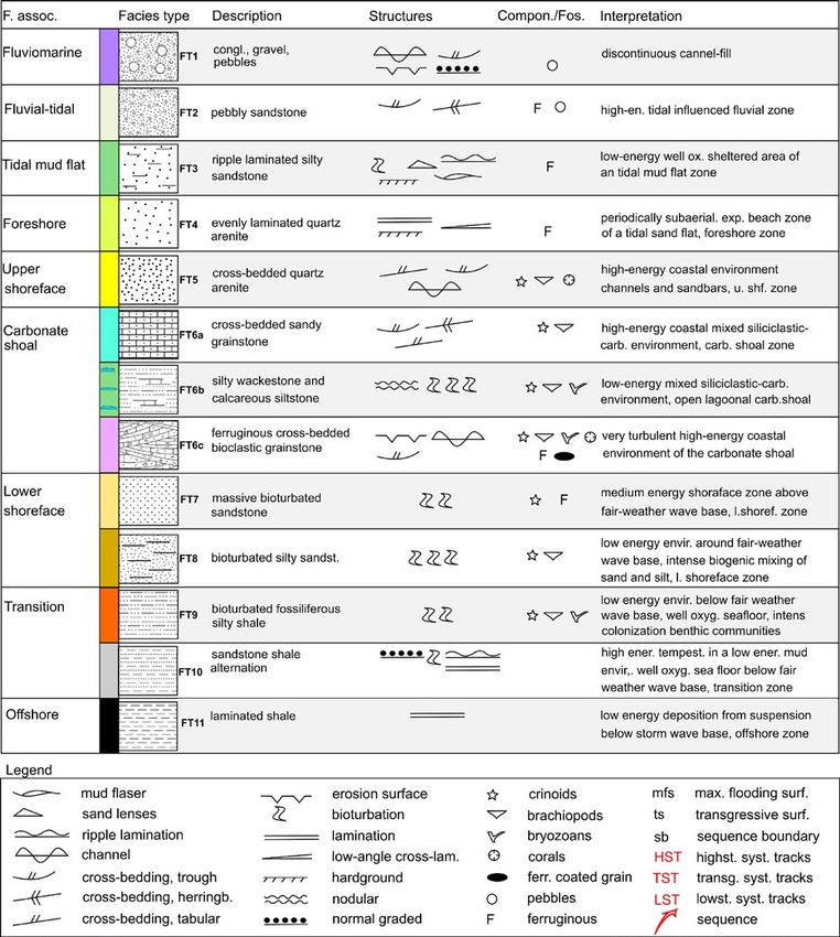
Van Loevezijn, G.B.S. et al., 2021. The Upper Devonian of the river Sil area... 132 (3): 325-354

                                                    VERSION ABREVIADA EN CASTELLANO

Introducción y Metodología                                                          Correlaciones

El área del Sil está localizada en la parte suroeste del                            Las secciones de Lumajo (Fig. 8), La Cueta (Figs 11,
dominio devónico Astur- Leonés de la Zona Cantábrica.                               12) y Meroy (Fig. 13) muestran arquitectura estrati-
En esta área, el Devónico Superior está principalmente                              gráfica similar y contienen un total de dos límites de
constituido por areniscas, muy similares a las areniscas                            secuencia: la primera, localizada en la base, entre los
de la Fm. Piñeres de la costa del Cabo Peñas (García-Al-                            depósitos arrecifales de la Formación Portilla y los si-
calde, 1978; Raven, 1983) (Fig. 1). Varias subdivisiones                            liciclásticos superpuestos de la Formación Nocedo,
de la sucesión estratigráfica del área del Sil han sido                             puede correlacionarse con la sb1 del área del Bernes-
propuestas (Van den Bosch, 1969; García-Alcalde, 1978;                              ga. Sobre dicha discontinuidad, la asociación de fa-
Van Loevezijn y Raven, 1984; Van Loevezijn, 1986).                                  cies se organiza en una secuencia granocreciente y
  Sin embargo, la escasez de fósiles y la falta de con-                             somerizante, con un tramo carbonatado en la parte
trastes litológicos de la monótona sucesión arenisco-                               inferior, de forma muy similar a la secuencia de facies
sa, dificulta la datación precisa de estos depósitos y                              del área del Bernesga, con evolución gradual desde
excluye, hasta ahora, una correlación definitiva con                                lutitas de plataforma (offshore) o de transición, has-
las lutitas y areniscas de sectores situados más al sur                             ta areniscas sublitorales (shoreface), sin la presencia
(Figs. 3, 4).                                                                       de ritmitas de areniscas y lutitas originadas por tor-
  Recientemente, un modelo de estratigrafía secuen-                                 mentas (Figs 14, 15). La correlación con la secuencia
cial fue introducido para el Devónico Superior del sec-                             A restringe la sucesión del Devónico Superior del área
tor sur de la Cordillera (Van Loevezijn y Van Loevezijn                             del Sil situada bajo el segundo límite de secuencia a
Peña, 2017). El objetivo de este trabajo es triple: pri-                            las zonas de conodontos valsiovalis Sup., hassi Inf, y
mero, establecer en detalle la conexión estratigráfica                              hassi Sup. (Van Loevezijn y Van Loevezijn Peña, 2017).
entre la Formación Piñeres de la costa y la secuencia                               Ello está en concordancia con la fauna de braquiópo-
ya establecida en la vertiente sur, aportando la es-                                dos de edad Frasniense existente en la parte media
tratigrafía secuencial del área transicional del Sil; en                            de la sucesión (García-Alcalde, 1978). Las areniscas
segundo lugar, correlacionar las sucesiones existen-                                lutíticas intercaladas en la parte inferior de la sección
tes en la vertiente sur de la Cordillera Cantábrica, y                              del Puente de las Palomas se atribuyen a la Formación
finalmente, reconstruir las etapas deposicionales del                               Fueyo (Fig. 9). Sobre ellas se sitúan las cuarcitas con
Devónico Superior en el área del Sil.                                               estratificación cruzada de la Formación Ermita (Fig.
  El marco estratigráfico se ha establecido mediante                                10). Ambas unidades forman parte de secuencia C del
el estudio de campo de cinco secciones situadas a lo                                modelo estratigráfico secuencial del Devónico Supe-
largo de un transecto suroeste-noreste en el área del                               rior elaborado por Van Loevezijn y Van Loevezijn Peña
Sil. La descripción de las facies y su interpretación se                            (2017). La segunda superficie límite en el área del Sil
han hecho siguiendo los procedimientos normales con                                 es claramente erosiva y separa la secuencia A de la
especial atención en las estructuras sedimentarias.                                 sucesión superior constituida por 24-28 m de arenis-
  El modelo estratigráfico secuencial del Devónico                                  cas microconglomeráticas con herringbone, conglo-
Superior de la vertiente sur de la Cordillera Cantábrica                            merados y calizas. Esta superficie límite erosiva pue-
contiene un total de cuatro límites de secuencia (sb1                               de correlacionarse con la discontinuidad sb4, entre las
hasta 4), representados por desplazamientos en la se-                               areniscas del Devónico Superior y los sedimentos de
dimentación a facies más profundas no adyacentes                                    grano grueso correspondientes a las Capas de Llom-
y/o episodios erosivos (Van Loevezijn y Van Loevezijn                               bera en el área del Bernesga (Fig. 16). Hacia el núcleo
Peña, 2020) (Fig. 14). Estos autores han dividido los                               de la Zona Cantábrica el proceso erosivo incrementó,
depósitos frasnienses de la Formación Nocedo en dos                                 y así, en la sección de Torrestío, la Discontinuidad del
secuencias somerizantes: la secuencia A del Miem-                                   Devónico Superior excavó un relieve de hasta 20 m
bro Gordón y la secuencia B del Miembro Millar. Las                                 en las calizas givetienses de la Formación Portilla, es-
pizarras de la Formación Fueyo y las areniscas de la                                tando rellena la topografía kárstica de areniscas ferru-
Formación Ermita, ambas de edad Fameniense, inte-                                   ginosas microconglomeráticas del Devónico Superior
gran la sucesión somerizante de la secuencia C. Sobre                               (Fig. 15).
ellas, la delgada sucesión de grano grueso de las Ca-                                  La Formación Piñeres en la sección de la playa de la
pas de Llombera y las calizas arenosas con crinoideos                               Gargantera de la costa asturiana, está integrada por
de la Formación Baleas, se incluyen en la secuencia                                 dos secuencias (Fig. 17). La inferior constituye una
D. En la costa de Asturias, al Devónico Superior se                                 sucesión somerizante de facies, en la que de forma
denomina Formación Piñeres y a las calizas con cri-                                 gradual se pasa desde lutitas de transición en la base,
noideos superiores, Formación Candamo (Figs 3, 5).                                  hasta areniscas de playas en el techo, sin presencia
Trece tipos de litofacies se han diferenciado en el área                            de capas de tormentas (Fig.18). El modelo y su po-
del Sil según la litología y estructuras sedimentarias                              sición estratigráfica sobre los depósitos arrecifales
(Figs 6, 7).                                                                        givetienses es similar a la secuencia A de las áreas

                                                                               326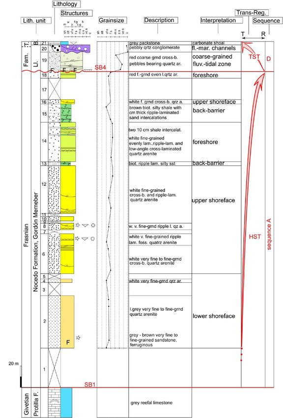
Van Loevezijn, G.B.S. et al., 2021. The Upper Devonian of the river Sil area... 132 (3): 325-354

del Sil y Bernesga. La alternancia de lutitas-areniscas                             secuencia C está integrada por la cuña clástica some-
que se superponen en esta área de la costa asturiana,                               rizante de las formaciones Fueyo y Ermita. En la parte
constituida por una potente sucesión de tempestitas                                 central del área del Sil, las secciones del Devónico Su-
de carácter somerizante (Van Loevezijn, 2020), debe                                 perior de son más delgadas y menos completas.
corresponder a parte de la secuencia Fameniense B o                                    Estas series contienen dos superficies erosivas. La
de la secuencia C. Provisionalmente, en este estudio                                primera está localizada en la base de la Formación
se correlacionan con la secuencia B por su posición                                 Nocedo y puede correlacionarse con la sb1 del área
estratigráfica, inmediatamente sobre la A (Fig. 19).                                del Bernesga. La segunda aparece en la parte más alta
  El modelo deposicional de la secuencia A muestra                                  de la serie y puede correlacionarse con la Discontinui-
transiciones graduales de las facies, con lutitas (FT11)                            dad del Devónico Superior sb4. La sucesión entre sb1
y lutitas bioturbadas (FT9) de zonas de transición, que                             y sb4 se correlaciona con la secuencia A en el área del
gradan a arenas de facies sublitoral inferior (FT8, FT7),                           Bernesga.
con desarrollo local de bancos carbonatados (FT6). La                                  El tramo delgado superior, integrado por areniscas
sucesión continua con extensos depósitos sublitorales                               microconglomeráticas y areniscas canaliformes, cons-
(FT5), playas (FT4) y llanuras de marea (FT3) (Fig. 20).                            tituye el techo del Devónico Superior en el área del Sil
En el área del Sil, los depósitos de la secuencia B no                              y puede correlacionarse con la serie condensada Fa-
afloran. El modelo deposicional de la secuencia C con-                              meniense-Tournaisiense de la secuencia D, representa-
tiene una sucesión cuyos depósitos evolucionan desde                                da por las Capas de Llombera y los 5 m de calizas are-
capas de tormenta distales (FT10), a sublitoral inferior                            nosas encriníticas de la Formación Baleas. La mayor
con arenas limosas, FT7, FT8), sublitoral superior con                              parte de las Areniscas de Piñeres de la costa asturiana
areniscas con estratificación cruzada (FT5), a fluvioma-                            se correlacionan con la secuencia A. El conjunto de al-
reales representados por arenas gruesas y microcon-                                 ternancias areniscas lutitas que le suceden en la playa
glomerados (FT4), y canales conglomeráticos fluviom-                                de la Gargantera, tentativamente se correlacionan con
arinos de llanura mareal arenosa (FT1) (Fig. 21). La                                la secuencia B del área del Bernesga por sus facies y
secuencia D contiene una sucesíón muy delgada de                                    situación sobre los materiales de la secuencia A.
carácter condensado con superficies de hardgrounds,
erosión y mineralización (García-López y Sanz-López,                                Introduction
2002a; Van Loevezijn, 2020), con una zona de canales
fluviomarinos proximales (FT1), carbonatos arenosos                                 The Upper Devonian rocks of the Sil area constitute
someros (FT6), y una zona fluviomareal distal, carac-                               the transition between the fine-grained Upper Devo-
terizada por areniscas microconglomeráticas con es-                                 nian of the southern mountain slope of León, and the
tratificación cruzada (FT2) (Fig. 22).                                              coarser-grained development of the northern slope of
                                                                                    Asturias (Fig. 1). Although the main part of the Sil area
Historia deposicional del Devónico Superior en el área                              is situated in León, the Upper Devonian succession
del Sil                                                                             consists mainly of sandstones, and is very similar to
                                                                                    the Upper Devonian Piñeres sandstone of Asturias in
Los sedimentos frasnienses fueron acumulados en                                     the north (García-Alcalde, 1978; Raven, 1983). Seve-
una cuenca sedimentaria marina con un perfil de-                                    ral Upper Devonian stratigraphic sub-divisions were
posicional gradual con mayor profundidad en la Zona                                 proposed (Van den Bosch, 1969; García-Alcalde, 1978;
Externa (SW) de la cuenca Asturo-Leonesa (Fig. 23).                                 Van Loevezijn and Raven, 1984; Van Loevezijn, 1986,
Más tarde, en el Fameniense Inferior, el núcleo de                                  Fernández et al. 2021). However, the scarcity of fossils
la Zona Cantábrica y partes adyacentes de la cuen-                                  hampers an accurate dating of these strata, and the
ca Asturo-Leonesa, fueron levantados y erosionados,                                 lack of lithological contrast of the monotone sandsto-
migrando el área deposicional hacia la Zona Externa,                                ne succession so far precludes a conclusive correla-
(SW) (Fig. 24). Durante el Fameniense Superior-Tour-                                tion with the Upper Devonian shales and sandstone
naisiense Inferior tuvo lugar un cambio deposicional                                in the south. Sequence stratigraphy can resolve the
desde una cuña clástica en la parte más externa de                                  correlation problem, allowing the introduction of se-
la cuenca Asturo-Leonesa, a una extensa platafor-                                   quences based on a sedimentological and sequence
ma marina ocupando el dominio previo del NE con                                     stratigraphical framework, and to use this as a corre-
erosión y exposición subaérea (Fig. 25).                                            lation tool.
                                                                                      The essence of sequence stratigraphy is that se-
Conclusiones                                                                        quence stratigraphic surfaces (sequence boundaries,
                                                                                    maximum flooding surfaces, etc.) represent timeli-
El flanco suroeste del sinclinal de la Vega de los Viejos                           nes and therefore it introduces a chronostratigraphic
contiene la sucesión más completa y potente del De-                                 framework (Catuneanu, 2017). Recently a sequence
vónico Superior del área del Sil. La secuencia A cons-                              stratigraphic model was introduced for the Upper
tituye una sucesión somerizante que va desde lutitas                                Devonian mixed siliciclastic-carbonate succession of
de plataforma (offshore) hasta areniscas sublitorales                               the southern Cantabrian Mountains (Van Loevezijn
(shoreface). La secuencia B no está representada. La                                and Van Loevezijn Peña, 2017). Hence the goal of this

                                                                               327
Van Loevezijn, G.B.S. et al., 2021. The Upper Devonian of the river Sil area... 132 (3): 325-354
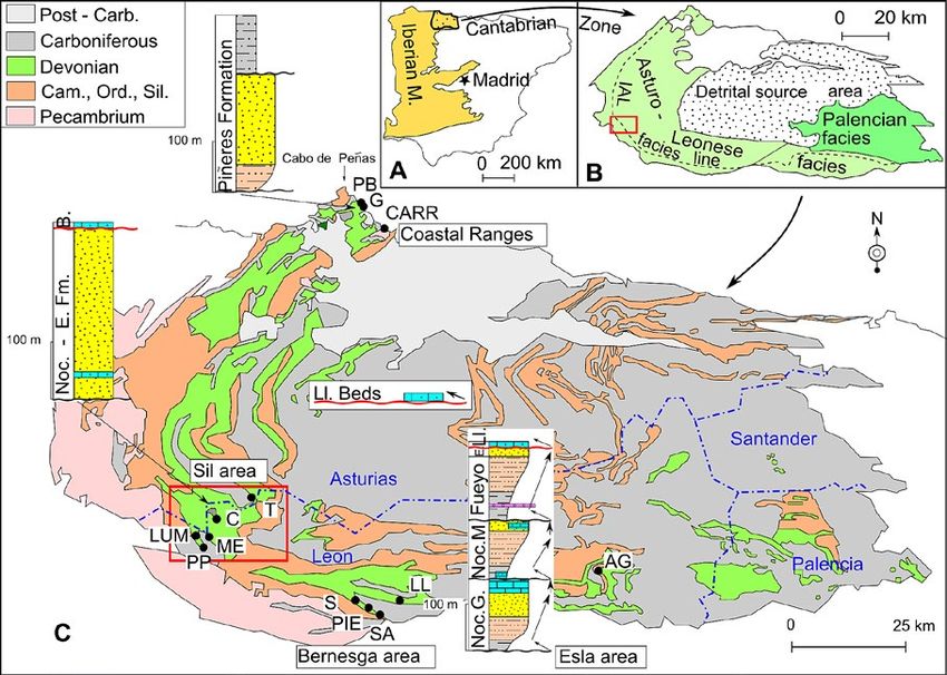
Figure 1. A) Situation map of the Iberian Peninsula with the Cantabrian Zone. B) Map of the Cantabrian Zone with the major palaeogeographic
units. C) Geological sketch map of the Cantabrian-Asturian arc with locations of the sections, changed after Herrero-Alonso et. al (2016).
Red square corresponds to the Sil region in Figure 3; Noc. G = Nocedo Formation Gordón Member, Noc. M. = Nocedo Formation, Millar
Member; E. = Ermita Formation, Ll. = Llombera Beds. Abbreviations for the sections; LUM = Lumajo, PP = Puente de las Palomas, ME =
Meroy, C = La Cueta, T = Torrestío, S = Saguera, PIE = Piedrasecha, SA = Soribos de Alba, LL = Llombera, AG = Aguasalio, PB = Playa de
Boletos, G = Gargantera, CARR = Carranques.
Figura 1. A) Mapa de la Península Ibérica con la localización del Macizo Ibérico y la Zona Cantábrica. B) Esquema geológico de la Zona
Cantábrica con las principales unidades tectonoestratigráficos. C) Mapa geológico de la Zona Cantábrica (modificado de Herrero-Alonso et
al.,2016) con tres sucesiones tipo sintéticas de las regiones del Cabo Peñas, Sil (rectángulo rojo) y Bernesga. Claves de las unidades: G. =
Miembro Gordón de la Formación. Nocedo, M. = Miembro Millar de la Formación Nocedo, E. = Formación Ermita, Ll. = Capas de Llombera.
Abreviaciones para las secciones: LUM = Lumajo, PP = Puente de las Palomas, ME = Meroy, C = La Cueta, T = Torrestío, S = Saguera, PIE =
Piedrasecha, SA = Sorribos de Alba, LL = Llombera, AG = Aguasalio, PB = Playa de Boletos, G = Gargantera, CARR = Carranques.
study is threefold: first to analyse the Upper Devonian and erosion surfaces, to identify the major bounding
stratigraphical sequences of the Sil area, secondly to surfaces, and to analyse the facies stacks between the
connect the established sequence stratigraphical mo- boundaries. Rock samples were studied in the labora-
del of the southern slope of the Cantabrian Mountains tory, grain size and sandstone percentages analysed,
with the sequences of the Sil area and to correlate the and thin sections studied. The field work was carried
succession to the Piñeres Formation in the north, and out in 1980-1982 and 2019-2021. The grain sizes were
finally to reconstruct the Upper Devonian depositio- classified according the Udden Wentworth scale, the
nal stages of the Sil area. sandstone was classified according to Dott (1964) ,
and the limestone according to Dunham (1962) and
Methodology Embry and Klovan (1972).
The stratigraphic framework of this fieldwork-based Geological setting
study contains the description of five outcrop sections
along a SW-NE transect in the Sil area. Facies des- The Cantabrian Zone is an arc shaped Variscan fo-
cription and interpretation were performed following reland fold-and-thrust belt, also known as the Can-
standard procedures with special attention to sedi- tabrian Orocline, related to the closure of the Rheic
mentological structures. The sections were worked Ocean and the collision between Laurussia and Gond-
out in detail including the recognition of facies jumps wana (Gutierrez-Alonso et al., 2004; Pastor-Galán et
328
Van Loevezijn, G.B.S. et al., 2021. The Upper Devonian of the river Sil area... 132 (3): 325-354

al., 2013). It is situated in the northwestern area of the                          ne and limestone mark the fundamental reorganisation
Iberian Peninsula, and is part of the Palaeozoic Iberian                            of the depositional system to Variscan sedimentation.
Massif (Lotze, 1945). The Cantabrian Zone is characte-                                 The condensed Mississippian succession is interpret-
rised by thin-skinned tectonics with a transport direc-                             ed as the initial starved foreland basin-fill (Kullmann and
tion towards the core of the arc (Fig. 2). On the basis                             Schönenberg, 1975; Keller et al., 2008). During the Penn-
of stratigraphic and tectonic features, the Cantabrian                              sylvanian the Cantabrian Zone became an overfilled fore-
Zone is sub-divided into several tectonostratigraphic                               land basin in front of the advancing orogen, and a thick
regions or units (Julivert, 1971; Peréz Estaún et al.,                              clastic wedge of synorogenic deposits were made up of
1988; Alonso et al., 2009): the fold and nappe area, the                            deep-water sediments, carbonates and deltaic deposits
Pisuerga-Carrión area, the Picos de Europa, the Pon-                                (Marcos and Pulgar, 1982; Matte, 1991; Martín-Merino et
ga nappe area, and the Central Coal Basin. The study                                al., 2014). These sediments are interpreted to have origi-
area is located in the fold and nappe area on the outer                             nated from the erosion of the internal zones of the Vari-
edge of the Cantabrian Arc.                                                         scan Orogen in the southwest which gradually extended
   The Cantabrian Zone contains a fairly complete,                                  their influence on the deposition in an eastward direc-
non-metamorphic to anchimetamorphic, Palaeozoic                                     tion, filling the foredeep trough.The advance of the defor-
succession. It can be divided into a pre-orogenic Cam-                              mation towards the foreland led to the development of
brian to Devonian succession and a Carboniferous sy-                                Westphalian thin-skinned thrust-sheet imbricated nappe
norogenic succession (Marcos & Pulgar 1982).                                        structures. The Westphalian sedimentation was mainly
   The pre-orogenic deposits consist of shallow marine si-                          synchronous with the deformation and tectonically con-
liciclastics and carbonates that are thought to have been                           trolled wedge-top piggy-back basins developed related to
deposited on a stable platform on the northern Gondwa-                              the emplacement of the different thrusts (Martín-Merino
na margin (Stampfli et al. 2013, Pastor-Galán et al., 2013).                        et al., 2014). By the end of the Carboniferous the Cantabri-
The succession thins towards the core of the Asturian                               an Zone had reached its definitive tectonic organization.
Arc, forming a depositional wedge (Fig. 2c). The transi-
tion from pre-orogenic to synorogenic deposition took                               Devonian Palaeogeographic units
place during the end of the Devonian (García-Ramos and
Colmenero, 1981; Keller et al., 2008).The Upper Devonian                            Several pre-Variscan palaeogeographic features con-
clastic deposits of the outer rim of the Cantabrian Zone                            trolled the Devonian depositional history.
are interpreted as the transitional tectono-sedimentary                               The facies area of the Devonian Asturo–Leonese Ba-
environment between the Devonian passive margin sta-                                sin (Brouwer, 1964), located in the fold and nappe area,
ge with extensive stable shelves, and the carboniferous                             is characterised by a shallow marine shelf succession,
synorogenic succession (Van Loevezijn, 2020).The wides-                             with a systematic change towards more proximal depo-
pread Upper Devonian unconformity and the overlying                                 sitional environments, and less continuous successions
transgressive thin succession of coarse-grained sandsto-                            toward the core of the Cantabrian Zone (Fig. 1b). The

Figure 2. A) Schematic map showing the location of the Cantabrian Zone B) Schematic geological map showing the main tectono-
stratigraphic units of the Cantabrian Zone, and the transport directions of the nappes (Julivert, 1971; Alonso et al., 2009) C) Stratigraphic
colums in the different tectono-stratigraphic units (changed after Alonso et al., 2009). Red square indicates location of study area.
Figura 2. A y B) Esquema geológico de la Zona Cantábrica con las unidades tectonoestratigráficas y direcciones de transporte de las
mismas (Julibert, 1971). C) Columnas sintéticas de las diferentes unidades (mod. de Alonso et al.,2009). Rectángulo rojo= área estudiada.

                                                                               329
Van Loevezijn, G.B.S. et al., 2021. The Upper Devonian of the river Sil area... 132 (3): 325-354

core was an area of uplift and erosion, characterised by                            Upper Devonian stratigraphic units
the near-complete absence of Silurian-Devonian strata,
and the source of the surrounding sedimentation basin                               The Devonian stratigraphy of the Asturo-Leonese fa-
(Sjerp, 1967; Van Adrichem Bogaert, 1967). The Devonian                             cies was described by Barrois (1882) in the northern
pelagic Palencian facies is located in the Pisuerga-Ca-                             slope of the Cantabrian zone (Asturias), and by Com-
rrión area in the east, and is considered allochthonous,                            te (1959) in the southern slope (León). These authors
representing the deeper south (western) continuation                                used different nomenclatures for the two areas. Al-
of the Asturo–Leonese Basin (Frankenfeld, 1984). In the                             though one name would be sufficient for each litho-
outer part of the Asturo-Leonese Basin the Intra-Astu-                              logical equivalent, the different names between Astu-
ro-Leonese facies line (IAL facies line) separates the Ex-                          rias and León are still currently used and are widely
ternal Zone with a thick and continuous Upper Devonian                              accepted. As can be expected there are also lateral
succession in the southwest, from the northeastern area                             lithological changes between the northern and sou-
with a thin and incomplete Upper Devonian succession                                thern slopes which cover a present-day distance of up
(Fig. 1b) (Sánchez de la Torre et al., 1977; García-Ramos                           to 100 km. These lateral changes occasionally compli-
and Colmenero, 1981; Raven, 1983; Van Loevezijn, 1986).                             cate the correlation between the areas (Fig. 5).
   The Upper Devonian of the Sil area is located in the                                The siliciclastic Upper Devonian in the south overlies
southwestern part the Asturo-Leonese facies area (Figs                              the Givetian reef deposits of the Portilla Formation.
1b, 1c). Its present-day geographical position on the                               It consists of the calcareous sandstone of the Noce-
border between León and Asturias is also known as                                   do Formation of Frasnian age, and the shales of the
the ‘Asturian Knee’, indicating a change in structural                              Fueyo Formation, and the sandstone of the Ermita For-
trend, where thrust and fold axes of the curved orogen                              mation, both of Famennian age (Comte, 1959) (Fig. 4).
of the Cantabrian Zone change from an E-W direction
of the southern Leonese part of the Cantabrian Moun-
tains to the N-S direction of Asturias (Fig. 1c). The area
is covered by the 1:50000 map of Van den Bosch (1969)
and by the 1:50000 IGME maps 101 Villablino (Vázquez,
1978), and 76 Pola de Somiedo (Rodríguez Fernández,
1979). The Sil area is dominated by three synclinal
structures: the southwestern Palomas or La Vega de los
Viejos syncline, the middle Quejo or La Cueta syncline,
and the northeastern Saliencia syncline (Fig. 3).

Figure 3. Schematic map of the Sil area showing the main synclinal
structures, and the location of the sections. IAL f. l. = Intra Asturo              Figure 4. Upper Devonian stratigraphic subdivision of the
Leonese facies line, PP = Puente de las Palomas, LUM = Lumajo, ME                   Esla-Bernesga and Sil areas, with the sequence boundaries-
= Meroy, C = La Cueta, T = Torrestío.                                               transgressive surfaces (sb/ts) indicated after Van Loevezijn (2020).
Figura 3. Mapa geológico esquemático del área del Sil, con localización             Fa. = Famennian.
de los principales sinclinales y secciones estratigráficas estudiadas.              Figura 4. Subdivisiones estratigráficas del Devónico Superior en las
IAL f.1. = Linea de facies Intra Astur- Leones, PP = Puente de las                  áreas del Bernesga y Sil, con los límites de secuencias transgresivas
Palomas, LUM = Lumajo, ME = Meroy, C = La Cueta, T = Torrestío.                     (sb/ts) según Van Loevezijn (2020). Fa. = Famenniense.

                                                                               330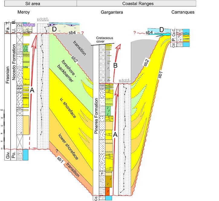
Van Loevezijn, G.B.S. et al., 2021. The Upper Devonian of the river Sil area... 132 (3): 325-354

The Givetian–Frasnian boundary is situated close to                                 1P in Fernández et al., 2021). The uppermost part of the
the base of the Nocedo Formation (García-López and                                  succession could be Famennian in age, although the
Sanz-López, 2002a). The Frasnian Nocedo Formation                                   scarcity of fossils hampers an accurate dating of these
ranges in thickness between 80 m and 450 m, and is                                  strata. Figure 5 shows the stratigraphic units in the dif-
sub-divided into a lower Gordón Member and an up-                                   ferent areas and the abbreviations used in this paper.
per Millar Member, each containing a shale-sandstone
coarsening upward succession with a limestone unit
on the top: the Molino limestone in the Gordón Mem-
ber and the Crémenes limestone in the Millar Mem-
ber. Locally, at the base of the Millar Member another
limestone occurs, the Varga limestone (Van Loevezijn
and Raven, 2017). The overlying, maximum 300 m thick
shale succession of the Fueyo Formation is of Famen-
nian age, and grades upward into the silty sandstone
of the Ermita Formation with a thickness of up to 96 m.
It is truncated by the Upper Devonian Unconformity.
Towards the NE, the unconformity represents deep-
er erosion, and in the core of the Cantabrian Zone it
cuts down to Cambrian strata (Fig. 2c). Above there is
a maximum 10 m thick succession of sand, conglom-
erate and coarse limestone, which form the Llombera
Beds. The Devonian-Carboniferous boundary is locat-
ed within these beds. The Llombera Beds are overlain
by a thin-bedded crinoidal limestone unit, the Baleas
Formation, or by the Tournaisian black shales of the Ve-
gamián Formation (Wagner et al., 1971). The limestone
intercalations of the Llombera Beds and the overlying
limestone of the Baleas Formation are similar in lithol-
                                                                                    Figure 5. Names and abbreviations of the stratigraphic units in the
ogy and facies, which makes differentiation between                                 different areas.
the two difficult (Raven, 1983).                                                    Figura 5. Nomenclatura de las unidades litoestratigráficas en las
   In the northern part of the Cantabrian Mountains                                 diferentes áreas.
along the Asturian coast the Upper Devonian is ex-
posed in the Cabo Peñas area of the Coastal Ranges,
with a thickness of more than 390 m in the western-                                 Upper Devonian facies types
most section (playas de Boletos, Gargantera), to 22–78
m in the east (playas de Carranques, Perán, Piñeres).                               The Upper Devonian lithology changes from fine
The equivalent of the Portilla Formation is known as                                grained sediments in the Bernesga area in the south
the Candás Formation. Radig (1961) introduced a new                                 towards coarser successions, almost without fine se-
unit for the overlying Upper Devonian siliciclastic suc-                            diments, in the Sil area. Therefore, the existing Upper
cession, the Piñeres Formation (Fig. 1c).The uppermost                              Devonian lithofacies types of the Bernesga and Esla
metre of the Candás Formation contains conodont fau-                                areas (Van Loevezijn and Van Loevezijn Peña, 2017;
nas representing the early Frasnian (García-López and                               Van Loevezijn and Raven, 2017, 2020) were adapted to
Sanz-López., 2002b), therefore in the coastal ranges the                            reflect the coarser successions of the Sil area, and a
boundary between the Candás limestone and the over-                                 few new facies types were introduced. Because of the
lying Piñeres Formation is close to the Givetian-Fras-                              sandstone dominance and the lack of fossils, Upper
nian boundary, but apparently slightly younger than in                              Devonian facies types of the Sil area are exclusively
León. In this study the Piñeres Formation in Asturias                               based on lithology and sedimentological structures.
is used as the equivalent of the Nocedo, Fueyo and                                  From each facies type a description and a short inter-
Ermita formations in León sensu Truyols et al. (1990).                              pretation is given. For a more detailed sedimentologi-
In the Sil area, the Devonian nomenclature of Com-                                  cal discussion, the reader is referred to the references
te (1959) will be used. The Upper Devonian is mainly                                given. The facies types of the Sil area are summarised
composed of sandstone with local (minor) intercala-                                 in Figure 6.
tions of shale, limestone and conglomerate. Fossils are
scarce. Conodont faunas in the lower part of the Upper                              FT1: Conglomerate facies
Devonian succession indicate early Frasnian (Van Lo-                                  Description: The discontinuous conglomerate
evezijn, 1986; García-López and Sanz-López, 2002b). A                               beds constitute shallow, 5 to 10 m wide, erosive
pre-Famennian brachiopod fauna occurs in the Upper                                  channel structures cutting down into the underl-
Devonian sandstone in the Vega de los Viejos syncline                               ying pebbly sandstone facies. The conglomerate
below the Upper Devonian Unconformity (sample PF1-                                  contains rounded quartzite pebbles up to 6 cm in

                                                                               331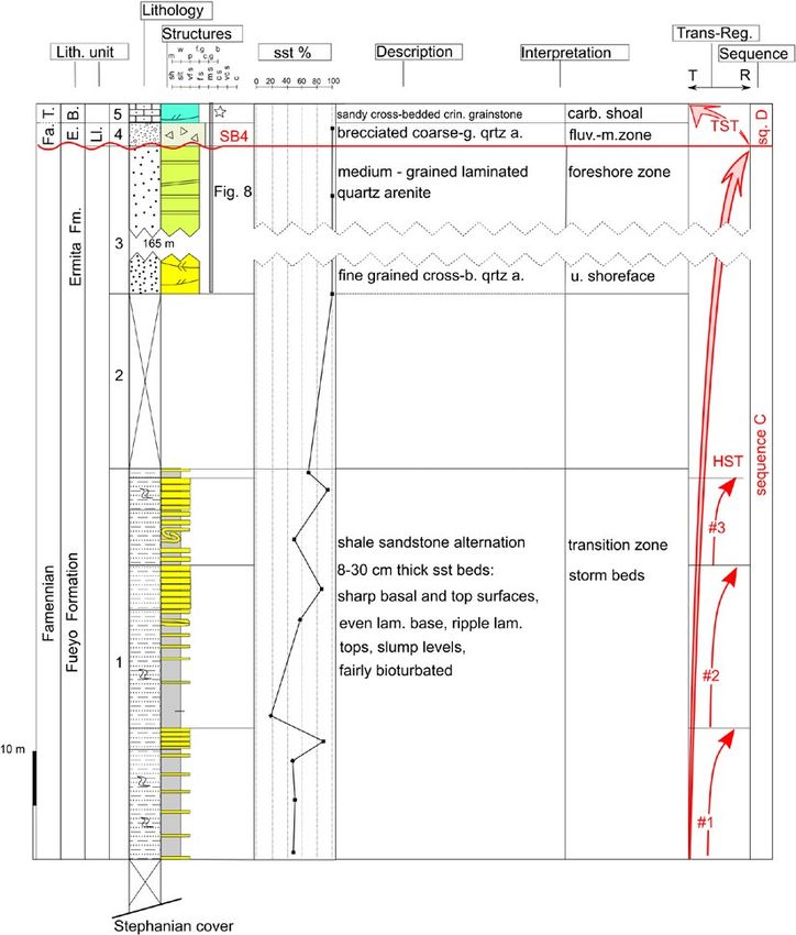
Van Loevezijn, G.B.S. et al., 2021. The Upper Devonian of the river Sil area... 132 (3): 325-354

Figure 6. Upper Devonian facies types and facies associations of the Sil area.
Figura 6. Tipos y asociaciones de facies del Devónico Superior en el área del Sil.

diameter. The sediments are organised in undula-                                    environment with turbulent conditions (Nichols,
ting erosive beds, with a lateral pinch-out geome-                                  2009). The pinch-out geometry of the wedge-shaped
try. Fossils are absent. Locally the conglomerate                                   bed forms, and the erosive lower surfaces of the beds
moves upward to very coarse-grained sandstone,                                      indicate channelised sediment bodies cutting down
and is overlain by a sandy grainstone bed or coar-                                  into the underlying sediment. The channels formed a
se-grained sandstone.                                                               network of fluviomarine channels and incised valleys,
  Interpretation: The rounded quartz pebbles and the                                located between the detrital source area in the NE and
absence of fine sediments represent a high energy                                   the depositional area in the SW.

                                                                               332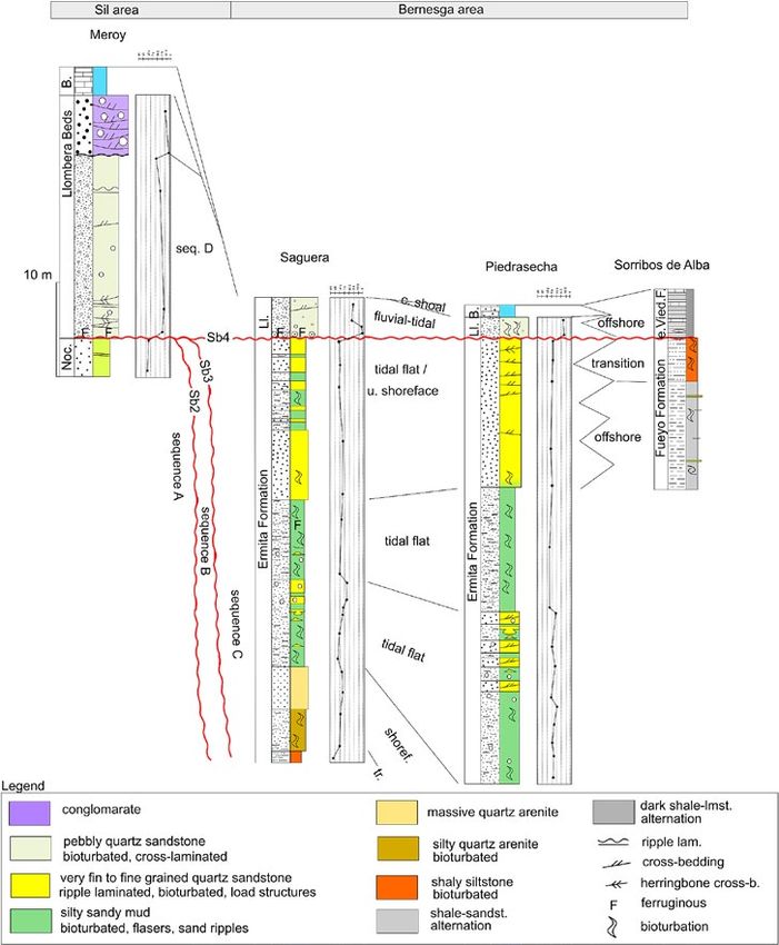
Van Loevezijn, G.B.S. et al., 2021. The Upper Devonian of the river Sil area... 132 (3): 325-354

FT2: Pebbly sandstone facies                                                        tivity in the foreshore zone (Reineck and Singh, 1975;
  Description: This facies type consists of medium to                               Nichols, 2009). The laterally persistent bored ferrugi-
coarse–grained quartz arenites with pebbles of up to                                nous horizons were formed by periodical subaerial
1 cm. Shales, silts and fine-grained sand do not oc-                                exposure of the sandflat area, where mud areas oc-
cur. The sediment locally contains an iron-stained                                  curred between the sand ridges (Van den Bosch, 1969;
red colour grading to light grey. Tabular and trough                                Van Loevezijn, 1986).
cross-bedded sets, locally arranged in herringbone                                  FT5: Fine to medium grained cross-bedded quartz are-
structures occur. The facies is intercalated in the top of                          nite facies
the Upper Devonian succession and locally rests with                                  Description: This facies type consists of light-grey to
a sharp erosive contact on the underlying sandstone                                 white, fine to medium–grained ripple laminated and
succession                                                                          cross-bedded sandstone. Locally the silica cement
  Interpretation: Herringbone structures are a diag-                                transforms the sandstone to quartzite. The 10-70 cm
nostic feature of the fluvial-tidal zone of river to coas-                          thick beds contain well-developed bedding surfaces.
tal plain estuary (Gosh et al., 2006; Van den Berg et                               Locally scarce mud drapes were observed between
al., 2007). The virtual absence of clay drapes and fine                             the pristine quartz arenite beds. Both tabular and
sediments is explained by fluvial avulsion in these ti-                             trough cross-bedded sets occur. Bioturbation is al-
dally influenced deposits.                                                          most absent. In the Meroy section moulds of coral,
                                                                                    brachiopods and crinoid ossicles occur locally in the
FT3: Ripple laminated bioturbated silty sandstone fa-                               cross-bedded quartz arenites.
cies                                                                                  Interpretation: The mineralogical and textural mature
  Description: This facies type consists of grey brown,                             sediment reflect a high-energy agitated water environ-
evenly laminated and ripple laminated very fine to                                  ment. Cross-bedded sets were formed by migrating
fine–grained sandstone arranged in 20 to 60 cm thick                                bars and channels in the shallow marine area of the
beds with a few cross-beds, alternating with mud in-                                upper shoreface zone. This resulted in texturally matu-
tervals with sand flasers and thin, up to 10 cm thick,                              re sediment without almost any bioturbation structures
sandstone beds. The asymmetrical ripple structures                                  (Reineck and Singh, 1975; Reinson, 1979; Nichols, 2009).
contain bifurcating, regular crests. Locally, the sedi-
ment is completely burrowed. This facies is intercala-
ted within the quartz arenites of (FT4), and (FT5).
  Interpretation: The fine-grained sediment and the in-
tercalation between shoreface and foreshore deposits
indicate low energy depositional conditions close to
the coast, partly sheltered from the high energy coas-
tal environment; the sheltered zone of a tidal flat, with
a low to mid tidal range (Reineck and Singh, 1975; Re-
inson, 1979).

FT4: Fine to medium-grained evenly laminated quartz
arenite facies
  Description: This facies type consists of white to light
grey coloured, fine to medium-grained, evenly lamina-
ted and low-angle laminated quartz arenites. Bioturba-                              Figure 7. A completely developed ferruginous soil containing a
                                                                                    ferruginous mineralisation surface and a rippled bioturbated mud
ted banded ferruginous mineralisation surfaces occur                                bed (after Van Loevezijn, 1986).
frequently (Van den Bosch, 1969; Van Loevezijn, 1986).                              Figura 7. Suelo ferruginoso bien desarrollado con superficie de
They are strata bounded, and are characterised by (Van                              mineralización de hierro y lutitas ondulantes bioturbadas. (basado
Loevezijn, 1986): (1) a limited thickness (0.5-2.5 m) and                           en Van Loevezijn, 1986).
vast lateral extension; (2) red and violet colours beco-
ming more intense from base to top; (3) topped by a
haematite–bearing mottled shale crust; (4) a gradual                                FT6: Limestone facies
transition of the lower boundary and a sharp upper                                    This facies type occurs in the lower part of the Upper
boundary (Fig. 7). The laminated quartz arenites occur                              Devonian succession, close to the underlying Portilla
in the upper part of the Upper Devonian succession,                                 Limestone Formation. The limestone facies consists of
and are intercalated between the cross-bedded quartz                                a mixture of carbonate and siliciclastic components,
arenite strata below (FT5), and the pebbly sandstone                                creating a variety of carbonate–siliciclastic combina-
(FT2) and conglomerate strata (FT1) above.                                          tions, with a gradual transition from siliciclastic do-
  Interpretation: The pure well-sorted character of the                             minated to carbonate dominated. Three limestone
quartz arenites, and the absence of matrix indicate                                 sub-facies can be distinguished: a sandy grainstone, a
deposition in agitated water above wave base. The la-                               bioclastic grainstone, and a silty wackestone.
minations were formed by swash and back-swash ac-

                                                                               333
Van Loevezijn, G.B.S. et al., 2021. The Upper Devonian of the river Sil area... 132 (3): 325-354

FT6a: Cross-bedded sandy grainstone                                                 oped as trough shaped sets. The bioclastic content is
  Description: This facies type consists of grey, very-fi-                          characterised by the accumulation of large quantities
ne to fine-grained, cross-bedded sandy grainstone.                                  of coarse echinoderm plates, crinoid ossicles, clasts
The components of the grainstone consist of quartz                                  of branching tabulate coral, brachiopods, bryozoans,
grains, with occasionally brachiopod and crinoid                                    and unidentifiable bioclasts.
bioclasts, cemented by calcite. The limestone is well                                 Interpretation: The deposits indicate a turbulent agi-
developed in 20 to 70 cm thick beds. Most of the                                    tated shallow marine environment in which sediment
cross-bedding consists of tabular sets, locally arran-                              was reworked by powerful currents, with constantly
ged in herringbone structures. Some trough cross-be-                                shifting channels and bars. In this turbulent environ-
dded sets were observed. The facies type has a gra-                                 ment fines were easily washed out. The sediment re-
dual contact with the calcareous sandstones of FT7                                  sembles coarse-grained bioclastic grainstone of fa-
and the silty limestone of FT6b. Towards the silty li-                              cies type 2c of the Upper Devonian Molino Limestone
mestone (FT6b) the texture changes from grainsto-                                   in the Bernesga area (Van Loevezijn and Raven, 2017),
ne to packstone with small amounts of micrite, and                                  and are similar to the cross-laminated bioclastic pack-
shale lenses between the limestone beds. Between                                    stone and grainstone of facies C of Burchette and
the calcareous sands of FT7 and the overlying sandy                                 Wright (1992), and the shoals and bank environment
limestone of FT6a, an upward gradual increase of cal-                               of the inner ramp setting of Flügel (2004).
careous content can be observed in the sandstone.
  Interpretation: The gradual transition to the massive                             FT7: Very fine to fine-grained massive sandstone
sandstone facies (FT7) indicates deposition close the                                 Description: Red coloured grading to brown colou-
shoreface zone. The facies type represents a carbona-                               red, locally ferruginous mottled, very fine to fine–gra-
te shoal environment that developed just above the                                  ined massive quartz sandstone, arranged in up to 80
lower shoreface zone, forming upper shoreface bars                                  cm thick beds. Cross-bedding is uncommon. The se-
and submarine topographic highs, and resembles the                                  diment is medium bioturbated. Locally some moulds
sandy grainstone of facies type 2a of the Upper De-                                 of crinoid ossicles can be observed. The lower part of
vonian Molino Limestone in the Bernesga area (Van                                   the facies succession is slightly calcareous. The facies
Loevezijn and Raven, 2017).                                                         is underlain by the bioturbated siltstones facies (FT8)
                                                                                    and overlain by the cross-bedded sandstone facies
FT6b: Bioturbated silty wackestone and calcareous                                   (FT5). Locally a (sandy) limestone succession of the
siltstone                                                                           carbonate shoal facies (FT6) is intercalated.
   Description: The facies consists of a grey-brown,                                  Interpretation: The absence of cross-bedded structu-
nodular alternation of thin bedded silty wackestone                                 res indicates deposition outside the upper shoreface
and calcareous sandy siltstone and shale. Bryozoans,                                zone of migrating longshore bars and shifting chan-
crinoids and brachiopods occur in large quantities.                                 nels, close to the fair-weather wave base. The massive
The sediment is heavily bioturbated and completely                                  sandstone facies represents the lower part of the sho-
reworked, which has caused its nodular mixed appea-                                 reface zone, a region composed of medium-bioturba-
rance. This facies type has a gradual contact with the                              ted very-fine to fine-grained sand with minor amounts
sandy limestone facies type (FT6a); close to the over-                              of ripple cross-bedding (Reineck and Singh, 1975; Ni-
lying sandy limestone the sandstone content gradua-                                 chols, 1999).
lly increases upwards, thus creating a gradual facies
transition between F6a and FT6b.                                                    FT8: Bioturbated silty sandstone
   Interpretation: The sediment indicates quiet water                                 Description: Brown coloured, calcareous, very fi-
conditions with a high biological mixing and contains                               ne-grained, nodular, thin bedded, silty quartz sands-
a close relation with the turbulent water environment                               tone. The sediment is intensely bioturbated and com-
of the carbonate shoal. We assume a semi-restricted                                 pletely reworked, resulting in nodular amalgamated
environment, with a shoal sheltering it from the high                               bed forms.
energy environment (Remane and Schlieger, 1971;                                       Interpretation: The bioturbated silty sandstone has
Schlager, 2005). The sediments resemble the silty                                   a gradual contact with the very fine-grained lower
wackestone of facies type 1a of the Upper Devonian                                  shoreface sandstones of FT7. The significant amount
Molino Limestone in the Bernesga area (Van Loevezi-                                 of silt in the sediment indicates deposition sea-ward
jn and Raven, 2017).                                                                of the main coastal sand area close to the fair-weather
                                                                                    wave base, where very fine-grained sand and silt was
FT6c: cross-bedded bioclastic grainstone                                            mixed with a very intense biogenic reworking (Rei-
  Description: This facies type consists of red to pur-                             neck and Singh, 1975; Nichols, 1999).
ple coloured ferruginous, coarse-grained cross-bed-
ded bioclastic grainstone, with a variable amount of                                FT9: Bioturbated silty shale
very-fine to fine-grained quartz sand. The well-devel-                                Description: This facies type is exposed in the ba-
oped beds are around 20-50 cm thick and have sharp,                                 sal part of section La Cueta, where it rests on the reef
erosive surfaces. Most of the cross-bedding is devel-                               deposits of the Portilla Limestone Formation, and in

                                                                               334
Van Loevezijn, G.B.S. et al., 2021. The Upper Devonian of the river Sil area... 132 (3): 325-354
the middle part of section Lumajo. It consists of grey, are amalgamating at the erosional surfaces. Most of
bioturbated, fossiliferous, calcareous, nodular, 10-50 the sandstone beds have sharp, gently wavy, locally
cm bedded siltstones grading to 1-10 cm bedded sha- clearly erosive basal surfaces, and sharp top surfaces.
les. The calcareous silty part contains large quantities They contain a structureless massive or even-lami-
of brachiopods. Crinoids and bryozoans also occur. nated basal part, and a wave-ripple laminated upper
In the Lumajo section a gradual transition can be ob- half. The silty shale in between the beds is fairly bio-
served between the laminated shales (FT11) and the turbated; locally completely reworked horizons occur.
overlying bioturbated silty shale (FT9). Upward the Soft sediment deformation structures can be obser-
silty shale facies grades to silty sandstone (FT8), and ved in the thick bedded successions. This facies type
calcareous sandstone (FT7). is only observed in the Fueyo Formation of section
Interpretation: The bioturbation and the abundance PP in the southwestern part of the Vega de los Viejos
of brachiopods and crinoids require well oxygenated syncline. The lower boundary of the shale-sandstone
bottom water conditions. We consider a low energy succession is mantled by Stephanian deposits, and
environment, with a regular supply of silty sediment. the upper boundary of the FT10 succession is not ex-
The gradual transition to coastal sandstone suggests posed.
a close relationship with the shoreface environment. Interpretation: The internal structures of the sands-
The sediments were deposited in the transition zone tone beds resemble the sequence of sedimentary
below the fair-weather wave base, where mainly silty structures generated by storm waves (Dott and Bur-
sediment accumulates, and where the biogenic pro- geois, 1982; Walker and Plint, 1992). The interbedded
cesses are dominant (Reineck and Singh, 1975; Ni- sand layers are the result of deposition during heavy
chols, 1999). storms when high suspended sediment concentra-
tions are introduced into the transition zone by offs-
FT10: Shale sandstone alternation hore directed gravity flows. In between storms, clay
Description: This facies type consists of a rhythmic and mud settled in the low-energy environment be-
alternation of grey brown, 8-30 cm thick, very fine– tween the fair weather and storm weather wave bases
grained sandstone beds and silty shale. The shale– (Myrow and Southard, 1996).
sandstone ratios range between 80-20 with thin-bed-
ded sandstone successions, to 10-90 with sandstone F11: Laminated shale
beds up to 30 cm thick. Locally the intercalated mud Description: This facies type mainly consists of pure
layers are very thin or absent, and the sandstone beds grey-brown laminated shale. Locally in the shale suc-
Figure 8. Log, grain size distribution, description, interpretation and sequence stratigraphy of the Lumajo section. Cd. = Candás Formation,
Po = Portilla Formation. For legend see Figure 6.
Figura 8. Columna, distribución granulométrica, descripción, interpretación y estratigrafía secuencial de la sección de Lumajo. Cd. =
Formación Candás, Po = Formación Portilla. (Leyenda en Fig. 6).
335Van Loevezijn, G.B.S. et al., 2021. The Upper Devonian of the river Sil area... 132 (3): 325-354
cession a gradual introduction of silty sediment is ob- were slowly deposited out of suspension beyond the
served. Bioturbation is low and this facies type has reach of the coastal sand supply, below the storm
very few fossils. It only occurs in the western limb of wave base in the outer shelf environment (Reineck
the Vega de los Viejos syncline. It rests on the limes- and Singh, 1975; Nichols, 1999).
tone of the Portilla Formation and is overlain by silty
deposits of the transition zone (FT 9). Facies stacks
Interpretation: Cross-bedded structures are absent
and no sand was introduced in this environment. The The westernmost outer part of the Sil area contains
activity of the current was extremely weak. Sediments the thickest Upper Devonian (Van den Bosch, 1969;
Figure 9. Log, grain size distribution, description, interpretation and sequence stratigraphy of the Puente de las Palomas section; Ll. =
Llombera Beds, E. = Ermita Formation, P. = Piñeres Formation, C. = Candamo Formation, B. = Baleas Formation. For legend see Figure 6.
Figura 9. Columna, distribución granulométrica, descripción, interpretación y estratigrafía secuencial de la sección del Puente de las
Palomas. Ll. = Capas de Llombera, E. = Formación Ermita, P. = Formación Piñeres, C. = Formación Candamo, B. = Formación Baleas.
(Leyenda en Fig. 6).
336Van Loevezijn, G.B.S. et al., 2021. The Upper Devonian of the river Sil area... 132 (3): 325-354
Van Loevezijn, 1986). Two sections were measured, Bosch, 1969; Van Loevezijn, 1986). However, part of
both located in the southwestern limb of the Vega de the Upper Devonian is covered by Stephanian depos-
los Viejos syncline: one near the village of Lumajo, the its and the succession is complicated and disturbed
other at Puente de las Palomas (Fig. 3). These sections by faults.
are complicated by faults and only parts of the Upper According to the Spanish IGME 50000 map nr 101,
Devonian are exposed. In the central part of the Sil Villablino (Vázquez, 1978) the lower half of the Upper
area the Upper Devonian succession becomes slight- Devonian section in Van Loevezijn (1986) containing
ly thinner and very sandy (Van Loevezijn and Raven, the Millar Member of the Nocedo Formation, must be
1984). Two well exposed Upper Devonian sections are interpreted as Stephanian. Only the upper half of the
located there. One is situated in the northeastern limb section can be attributed to the Upper Devonian (Van
of the Vega de los Viejos syncline along the road to den Bosch, 1969). The section consists of several parts,
Pola de Somiedo (Meroy section; Fig. 3). The second exposed along the curves of the old road (Fig. 9). From
one is located in the southern nose of the La Cueta the stratigraphic reconstruction a 38 m thick coarsen-
syncline along the east side of the road near Quejo (La ing upward succession emerges, consisting of silty
Cueta section; Fig 3). Towards the northeast, near the shale alternating with very fine-grained laminated
village Torrestío, a thin and incomplete Upper Devoni- graded sandstone beds (FT10) with slump levels and
an succession is exposed in the nose of the Saliencia shallow channels (unit 1). The top of the shale-sand-
syncline. stone interbedded succession is not exposed (unit
2). Above 183 m of light grey quartz arenites occur
Sil area; Lumajo section (LUM) (unit 3), with trough and tabular cross–bedded inter-
Description: North of Lumajo the lower part of the vals (FT5), as well as even laminated and low-angle
Upper Devonian succession is exposed (Van den cross-bedded parts (FT4) (Fig. 10). Locally the quartz
Bosch, 1969; Van Loevezijn, 1986) (Fig. 8). The base of arenites are eroded by conglomerate intercalations
the section, located near the village Lumajo consists (FT1). Above 3.8 m of brecciated pebbly sandstone
of a 30 m thick succession of grey brown pure shale occurs (FT2) (unit 4). The uppermost part of the sec-
(FT11). The uppermost part becomes silty, grading to tion consists of 5 m cross–bedded sandy crinoidal
bioturbated silty and sandy shale. (FT9). Above it, 6 m grainstone (FT6a) (unit 5). Units 4 and 5 correlate with
of very calcareous bioturbated sandstone occurs, gra- the 12 m of bioclastic and sandy limestone of section
ding into sandy limestone, with brachiopods and cri- VV above the Upper Devonian Unconformity (sb4) in
noids (FT8), overlain by 6 m of cross-bedded very fine Fernández et al. (2021). However, they used a different
to fine-grained quartz arenites (FT5). The upper 20 m stratigraphic nomenclature and named it the Ermita
consists of purple coloured, poorly exposed cross-be- Formation; in this study the sandstone succession
dded ferruginous fine-grained sandstone with trough above the shale of the Fueyo Formation is known as
cross-bedding locally organised as herringbone struc- the Ermita Formation (Comte, 1959) whilst the thin
tures (FT5). The top of the section is badly exposed (course-grained) siliciclastic succession above the un-
and cut off by a fault. The overlying strata are partly conformity is called the Llombera Beds (Keller et al.,
exposed south of Lumajo near the old road to Puente 2008; Van Loevezijn and Van Loevezijn Peña, 2017).
de las Palomas (section PP). Grain size distribution: The sand of the interbed-
Grain size distribution: The facies stack displays a ded shale sandstone succession is very fine-grained.
very gradual coarsening upwards without spikes, To investigate the overall grain size distribution, the
from shale in the basal part, to silt followed by very sandstone percentages were logged. The facies stack
fine-grained sand, with fine–grained sand at the top displays a gradual coarsening upwards without major
of the section. spikes, organised into three small-scale cycles, with
Interpretation: The contact between the reefal li- values ranging around 20 for the basal part, to 90 in
mestone of the Portilla Formation and the overlying top of the section.
shale (FT11) of the Nocedo Formation represents a fa- Interpretation:The gradual upward increase of the bed
cies jump to offshore. Both the stepwise shallowing thickness and sand percentage of the storm-bedded suc-
upward development from offshore to shoreface, wi- cession of FT10 are indications of a gradual shallowing
thout abrupt facies shifts, and the gradual coarsening upward trend (Fig. 9). The overlying sandstone-conglo-
upward grain size curve without major excursions, in- merate facies stack represents an upward facies change
dicate a single, genetically related depositional cycle. from shoreface to foreshore, with conglomerate channel
The top of the section is cut off by a fault, therefore it intercalations. Above the sequence boundary sb4 the 3
does not display the complete cycle. to 4 m of brecciated pebbly sandstone of the fluvio-tidal
zone occurs, overlain by the cross-bedded grainstone
Sil area; Puente de las Palomas section (PP) succession of the carbonate shoal zone (Fig. 10).
Description: In the western limb of the Vega de los
Viejos syncline near the old mountain road between Sil area; La Cueta section (C)
Puente de las Palomas and Villaseca, the upper part of This section is exposed in the Sil valley 500 m north
the Upper Devonian succession is exposed (Van den of the village of Quejo, along the east side of the road
337Van Loevezijn, G.B.S. et al., 2021. The Upper Devonian of the river Sil area... 132 (3): 325-354
Figure 10. Detailed log of the upper part of section Puente de las Palomas in Figure 7. Ll.= Llombera Beds, E. = Ermita Formation, P. = Piñeres
Formation, C. = Candamo Formation, B. = Baleas Formation. For legend see Figure 6.
Figura 10. Columna detallada de la parte superior de la sección del Puente de las Palomas (Fig. 7). Ll.= Capas de Llombera, E. = Formación
Ermita, P. = Formación Piñeres, C. = Formación Candamo, B. = Formación Baleas. (Leyenda en Fig. 6).
fining upward succession from brachiopodal calca-
reous siltstone to shale (Fig. 12: unit 1). Above a 10 m
thick succession of bioturbated siltstone and fine-gra-
ined sandstone of FT7 and 8 occur (Fig. 12: unit 2).
The fine-grained sandstone change upward to sandy
grainstone (FT6a) of the mixed siliciclastic carbona-
te succession of unit 3. Above the sandy grainstone,
fossiliferous bioturbated silty wackestone and calca-
reous siltstone occur (FT6b), with two purple coloured
coarse grained bioclastic intervals (FT6c). The section
continues with 49 m of ferruginous sandstone, fo-
llowed by 32 m of grey fine-grained quartz arenites
Figure 11. Description and interpretation of the contact between
(FT7) (units 4-8). The succession is overlain by 33 m of
the Portilla Formation and the Nocedo Formation of the La Cueta
section. light-grey fine-grained cross-laminated quartz areni-
Figura 11. Descripción e interpretación del contacto en las tes (FT5) (unit 9), followed by 16 m evenly laminated
formaciones Portilla y Nocedo en la sección de La Cueta. and low-angle cross-laminated quartz arenites (FT4),
containing bioturbated banded ferruginous minerali-
to La Cueta (Fig. 3), in the southern nose of the La sation surfaces and rippled mud beds (FT3) (unit 10).
Cueta syncline. The uppermost 18 m consist of course–grained quartz
Description: The contact between the reef limesto- arenites and conglomerates with granules up to 0.5
ne of the Portilla Formation and the Upper Devonian cm (unit 11). Above 8 m of the unexposed section (unit
siliciclastic succession is a flat bounding surface (Fig. 12), Namurian dolomites of the Barcaliente Formation
11). The grey Portilla limestone is overlain by a gradual are found.
338También puede leer