ANALYSIS FILE - THE GREATER PUEBLA - Ateliers
←
→
Transcripción del contenido de la página
Si su navegador no muestra la página correctamente, lea el contenido de la página a continuación
ANALYSIS FILE - THE GREATER PUEBLA
Metropolization and Historical Center
A Sustainable, Operational and Collective Development
INTRODUCTION                                                                visit in November 2011. Then, the team met the
                                                                            Government authorities, the civil society figures
                                                                            and many other figures. Thanks to those meetings,
                                                                            the main topics of the “amazement report”, that
                                                                            was conducive to the document released in Febru-
                                                                            ary 2012 to introduce the stakes of the workshop.

This analysis file is part of a series of documents released by « Les       On the basis of that former work, an international
Ateliers » for Puebla workshop. It aims to give the participants an         call for application was launched and 178 candi-
overview of the territory they will work on during a two week inten-        dates answered, quite an outstanding figure for
sive workshop.                                                              “Les Ateliers”. Then it was necessary to make a
                                                                            hard selection among so many highly interesting
The following analysis was made through interviews with actors              candidatures. Now the new professional of the city,
from the City and from Puebla Government, from the civil society,           namely the selected candidates, will have to imag-
unions and universities, as well through academic research and              ine proposals and projects for Puebla City.
through analysis in the field. Despite all our will to stay as objective    The workshop, organized at mid-term of the
as possible, this work may reveal a personal point of view. Thus, it        three-year term of the City’s Council, should build
may include mistakes, given that its authors are neither Poblanos nor       a framework and suggest reflections and actions
Mexicans. That’s the reason why we worked intensively and rigorous-         on different time and space scales, to address the
ly, during one month and a half, to collect the needed information          future organization of the territory.
and to write one document as complete and worthy as possible.
                                                                            Finally, we should keep in mind that the workshop
During our research/investigation, we faced some hindrances: overall        couldn’t take place without the preparation and
trouble to access the information here in Puebla, trouble caused by         combined efforts of Puebla city and the French
the lack of coordination between the several governance strata (the         Embassy in Mexico (IFAL), and with the financial
Federal State, Puebla Government and the City), as well as the gap          support of our partners CITELUM and the federal
between planning and operational implementation. Both the work-             SEDESOL, without which it would have been im-
shop topic and Puebla City is complex. The stake of consistency of          possible to organize the workshop.
the metropolitan-scale thought stresses the necessity to implement
a process that associates every governance stratum. Such necessity
might be one condition so that the workshop results in concrete ac-
tions.

The current situation in Puebla illustrates the relationship between
metropolization process and the city-center. The city is actually           CREDITS
growing and sprawling whereas the city-center is depopulating.
Then, among other goals, the workshop aims to discuss the spatial           •   Thomas Casanova y Angela María Jiménez, archi-
organization and the urban strategy one should implement in order               tects and assistants. Research, writing of the analysis
to develop the territory. Let’s keep in mind that the territory, namely         file.
Puebla city-center, is included a Mother-City or metropolis, itself         •   Anne Durand, architect and Jean-Michel Vincent,
included in a 2,5 -million-inhabitant and a 38-city State.                      engineer, pilots
One striking point in urban development process is the leading role         •   Antoine Plane, deputy director of Les Ateliers
of the private sector. As far as housing is concerned, illustrations of     •   Edson Andrade, graphic design
such role are on the first hand informal urbanization and on the other      •   Berenice Vidal, local team. Orientation in Puebla
hand the huge development of the “fraccionamientos cerrados”,               •   Víctor Manuel Marín, local team. Lecture and correc-
large condominiums that are spreading in the suburbs. Like in many              tion of this analysis file
Latino-American cities, private assets play a predominant role in ur-       •   Photos: Thomas Casanova pages 9, (image 17), 33
banization, urban development and the provision of services (what-              (2), 35 (images 1 y 2), 49, 50, 51, 55, 69 (images 1, 3,
ever their quality). In fact, condominiums, that create closed spaces,          4, 6, 7), 70, 71, 83 (Image 3), 93, 95, 97, 98, 103, 109,
are not proper to Puebla. They are a fast-growing phenomenon in                 110, 115 (Image 4), 125, 126, 127, 129, 131, 132,
Mexico as well as in other countries and are the spatial consequences           135, 137, 139, 140, 141.
of a search of safety in the city. As a result, the city proves to be so-   •   Ángela María Jiménez Avilés, pages 33, 34, 35, 37,
cially and spatially fragmented.                                                58, 59, 62, 83
Let’s note that the subject “Metropolization and the historic city-cen-     •   Traslation: Thomas Casanova (French) Ángela María
ter” is the result of common refection and agreement made “Les Ate-             Jiménez (Spanish) Sabine Bognon, Cecile Brune,
liers” and the City’s Authorities on the occasion of “Les Ateliers”’ team       Caroline Brunel (English)

2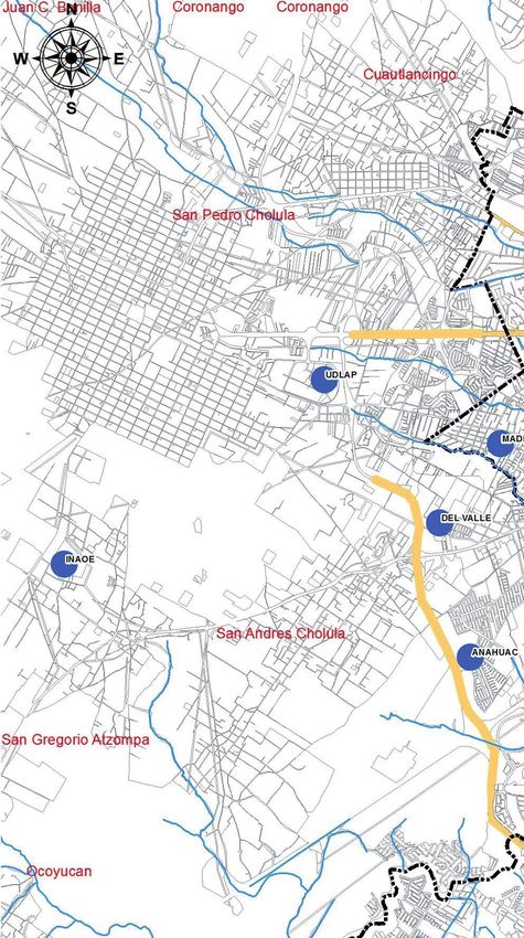
ACKNOWLEDGMENTS
                                                                                Juan Quintana Moreno, Presidente de la CITEX (Cámara
                                                                                de la Industria Textil Puebla Tlaxcala) Juan Caballero
                                                                                Ropero, desarrollador inmobiliario; Héctor Fernández de
                                                                                Lara, propietario del Hotel Boutique “El Sueño”; Leobardo
                                                                                Espinoza, Director General de la emisora Radio Puebla
Specially acknowledgment for Eduardo Rivera Pérez, Mayor of Puebla. Pedro
                                                                                Prioridad; José Luis Escalera, propietario de Profética:
Ocejo Tarno, Secretary for Economic Development and Tourism of Puebla
                                                                                Casa de Lectura; Adán Domínguez, Secretaría Técnica
City and his team: Berenice Vidal Castelán and Víctor Manuel Pedro Marín
                                                                                de Presidencia; Alicia Tecuanhuey, Instituto de Ciencias
Meléndez. Yann Thoreau la Salle, Technical Cooperation at Embassy of France
                                                                                Sociales y Humanidades BUAP. Hugo Arzola y Adriana
in Mexico and Rajaâ Nouali projects director.
                                                                                Henández, Secretaría de Desarrollo Social del Municipio
                                                                                de Puebla; Edson Andrade y Angélica Martínez, Secreta-
Other people who make possible this document:
                                                                                ría de Desarrollo Económico y Turismo; Gustavo Rámirez,
                                                                                Colectivo Laalvaca; Luis Ernesto Derbez, Rector de la
Ana María Verónica Mastretta, Regidora, Presidenta de la Comisión de Ecolo-
                                                                                UDLAP; Marie France Desdier, Jefa de Espacios Cultura-
gía y Medio ambiente; Javier Sánchez Díaz de Rivera, Secretario de Desarrollo
                                                                                les de la UDLAP, Alonso Pérez Fragua, Capilla de Arte de
Social y Participación Ciudadana; Gerardo Vargas, Subsecretario de Desarro-
                                                                                la UDLAP; Emma Morales García Directora Departamento
llo Urbano y Ordenamiento Territorial del Estado; Talia González, Directora
                                                                                de Arte, Diseño y Arquitectura de la UIA; Josefina Buxadé
de Ordenamiento Territorial del Estado; María Élena Rubí, Subdirectora de
                                                                                Castelán, José Antonio Gali López; Mónica Osorio,
Planeación; Delfino Sánchez Romero, Jefe de Regulación de Zona de Monu-
                                                                                Directora de Planeación de la Secretaría de Transpor-
mentos y Patrimonio; Elodia Márquez, Gloria Castro y Édgar Vélez Tirado de
                                                                                tes de Puebla; Víctor Mata Temoltzin, Subsecretario de
la Secretaría de Desarrollo Urbano y Obras Publicas; David Méndez, Regidor,
                                                                                Planeación y Desarrollo de la Secretaría de Transportes
Presidente de la Comisión de Desarrollo Urbano y Obras Publicas; Luis Eduar-
                                                                                del Gobierno del Estado de Puebla; Fernando Manzanilla
do Olmos, Coordinador General del IMPLAN; Mario Iglesias y García Teruel, ex
                                                                                Prieto, Secretario General del Gobierno del Estado de
coordinador del IMPLAN; Mario Ricciardi, Secretario Particular del IMPLAN;
                                                                                Puebla; Teresa Márquez, Directora del Museo Nacional de
Verónica Carmona; Vinculación institucional del IMPLAN; Angélica Patricia
                                                                                los Ferrocarriles Mexicanos; Rosa María Licea, Museo del
Hidalgo, IMPLAN; María Pía Benítez de Unanue, Coordinadora académica de
                                                                                Ferrocarril Puebla.
postgrados de arquitectura y vivienda de la UPAEP, Carlos Montero Pantoja,
BUAP; Alejandro Cañedo Priesca, Director de la Oficina de Turismo; Walther
                                                                                Our deep acknowledgment for our partners and financial
Junghanns Albers, Director de Desarrollo para una Ciudad Competitiva;
                                                                                sponsors: Embassy of France in Mexico, CITELUM and
Rafael Barquero Díaz Barriga, Subdirector del INAH Puebla (Instituto Nacional
                                                                                SEDESOL
de Antropología e Historia); Ignacio Acevedo Ponce de León, Presidente del
Comité para el Repoblamiento del Centro Histórico; Francisco Valverde, doc-
tor en urbanismo y director de investigación de la Universidad Iberoamerica-
na Puebla; Benito Cabañas, Colectivo Abracadabra; Christiane Doilin , direc-
ción general de CITELUM; Ricardo Larracilla, Director de Abasto y Comercio
Interior del Municipio de Puebla; Martha Niño Directora de Sustentabilidad
Urbana en la SEMARNAT; Miguel Martín Ramos, Jefe del Departamento de
Dictámenes Técnicos, Subsecretaría de Desarrollo Urbano y Ordenamiento
Territorial; Juan Ángel Martínez Rodríguez, Consultor Nacional Programa de
las Naciones Unidas para los Asentamientos Humanos; Oscar Soto, profesor
de la Universidad Iberoamericana Puebla; Ezequiel Aguilar y Fred Dionne,
miembros del Colectivo Metropolitano; Guillermo Morales Sotomayor, Co-
lectivo Tomate; Felipe Velázquez Gutiérrez, Secretario de Desarrollo Urbano
y Obras Púbicas; Christian López Ballinas, Jefe de Vialidad y Transporte;
Francisco Bada Sanz, Asesor del Alcalde; Francisco Vélez Pliego, Presidente
del Consejo del Centro Histórico; Luis Espinosa Rueda, presidente de CANA-
CINTRA (Cámara Nacional de la Industria de Transformación); Luis Javier Cué,
Presidente de CANIRAC Puebla(Cámara Nacional de la Industria de Restau-
rantes y Alimentos Condimentados); Luis Rodríguez Fernández, Presidente
de CCE; Gabriel Posada Cueto, Grupo Proyecta (desarrollador inmobiliario);

                                                                                                                                       3
SUMMARY*
Only black chapters have been translated to English. French and Spanish versions are available in http://www.ateliers.org/content/
metropolisation-et-centre-historique

Chapter I                                                      Chapter IV
                                                               HOUSING DEVELOPMENT PROCCES
General information                                            Urban sprawl
Chronology                                                     Social housing
Mexico: general aspects, environment and limits                Angelópolis: urban land reserve
Mexico: Demographics and Economics                             Fraccionamientos
The Greater Mexico City                                        Urban reglamentation
State of Puebla                                                Autoconstruction and informal housing
State of Tlaxcala

                                                               Chapter V
The Greater Puebla in the national context
The metropolitan history
Greater Puebla
Puebla City
Main cities of the metropolitan area
                                                               CITY CENTER

Chapter II
                                                               An Attractive but Depopulated City-Center—      36
                                                               Duis Resettlement Project — 41
                                                               Puebla City of Knowledge— 44
THE GREATER PUEBLA                                             Regulations In The City Center—      45
                                                               Industrial Wastelands—       46
Urban Planning in the Metropolis— 6                            Which Center ?— 50
Population and Social Aspects—     8

                                                               Chapter VI
Production, Gnp and Employment in the Metropolis—
10
Public Transportation—        12
Informal Trade— 16
History Of The Textile Industry—   18
                                                               Metropolitan Landscape
The Railway—        20
                                                               Urban landscape
Tourism —           24
                                                               Agricultural landscape
Puebla, University Town— 26
                                                               Natural landscape
Puebla, City Of Design — 30

Chapter III                                                    Bibliography
SUSTAINABLE DEVELOP-                                           Bibliography       55
                                                               Abbreviations—     61
MENT AND URBAN MANAGE-                                         Practical Links—   62

MENT
Looking for a sustenable metropolitan area
Sustenable indicators.
Water quality
Air quality
Transportation
Solid Waste Management
Risks areas

4
CHAPTER II
THE GREATER
PUEBLA        5
URBAN PLANNING IN THE
METROPOLIS

Given the urban process and flows                                         to define priorities, policies and
                                                                          strategies one should carry on
                                                                                                                 1 Programa Nacional
                                                                                                                 de Desarrollo Urbano y

between Puebla and the neighbor ur-                                       for the metropolitan zone.
                                                                          The Office has different purpos-
                                                                                                                 Ordenación del Territorio
                                                                                                                 2000-2006 (PNDUyOT).
                                                                                                                 Iracheta, Alfonso.

ban areas, it seems that the question                                     es, among which:
                                                                                                                 2 Programa de la zona

of the definition of Puebla metropolis                                    -          To design plans, studies,   metropolitana; 2009.
                                                                                                                 Hernández, Castillo,
                                                                          programs, projects (especially         Órnelas.
                                                                          concerning infrastructures and
is complex. There are today several                                       facilities), to get funds from
                                                                          the Metropolitan Fund (“Fondo
examples of definition or attempts to                                     metropolitano”). Then, the proj-
                                                                          ects have to be consistent with
define Puebla metropolitan area.                                          the Development National Plan
                                                                          (“Plan nacional de Desarrollo”).
                                                                          -          To choose to give prior-
People have tried for some years to define Puebla metropolis and          ity to certain projects,
have tried to implement a metropolitan-scale urban planning policy        -          To deal with other proj-
too, without any success. The important gap between every attempt         ects or programs in favor of the
of definition of the metropolitan zone shows how much the topic is        metropolitan zone development,
complex. Depending on the cases, the metropolitan zone includes           -          To establish criteria to
from 24 cities to 94 cities. At least, in every case, the metropolitan    define the consequences of the
zone spreads beyond Puebla neighbor cities.                               measures implemented in the
                                                                          metropolitan zone.
Among the definition studies of the metropolitan zone, we have
just studied the case of the metropolitan zone Puebla -Tlaxcala. In       The Metropolitan Office is
2003 the Program for the conurbation area Puebla-Tlaxcala was             funded by the “Fondo Metropoli-
established (“Programa de Zona Conurbana Puebla - Tlaxcala”). Then,       tano”, itself funded by the Federal
in 2009 the Program for the metropolitan zone Puebla - Tlaxcala           State. As a result, the Metropoli-
and the Territorial urban planning project of the metropolitan zone       tan Offices have to inform the
Puebla - Tlaxcala were established (“Programa de Zona Conurbana           Federation about their activities.
Puebla - Tlaxcala”). Finally, in 2010, a global planning model (“modelo   The Offices are composed of rep-
de Planeacion Integral”) was established. None of the plans were          resentatives from the States of
implemented. Let’s note that a new plan is said to be under work. All     Puebla, from the State of Tlaxcala
of those projects attempt to propose large-scale strategies for Puebla    and from the Federation (Illustra-
metropolis.                                                               tion 2).

THE METROPOLITAN ZONE ADMINISTRATION                                      Let’s note that, in the 2009
                                                                          Agreement, there is no reference
Despite the trouble to define a consistent metropolitan zone and          to the potential participation or
to implement metropolitan-scale planning tools, there is today a          integration in the Office of the
regulation office for the metropolitan zone (“ZMPT”), called the Office   cities that are part of the metro-
for the metropolitan development of the “ZMPT” (Consejo para el           politan zone or of the IMPLAN
Desarrollo Metropolitano de la Zona Metropolitana Puebla-Tlaxcala).       (the Planification Institute of the
It was created on October, 2nd, 2009. The metropolitan zone was           City).
jointly defined by the SEDESOL, the CONAPO and the INEGI. The of-
fice includes teams from the State and from the Federation. They aim
6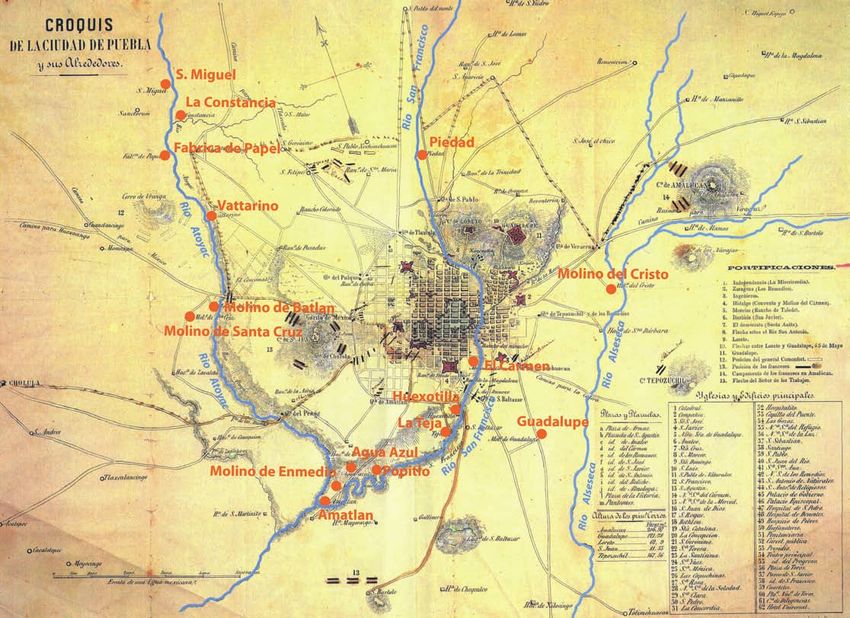
The Office members meet periodically. Their title as
member is honorific and they don’t earn any salary.
The Office is composed of Secretary of States and
of deputy Secretary of States.

On the occasion of the late Office meeting that
took place in March 2012, the Governors of Puebla
and Tlaxcala States signed collaboration agree-
ments. The mayors of Puebla and Tlaxcala Cities
were present at the meeting. The discussed proj-
ects deal with the recuperation of Atoyac, Zahupan
and Alseseca Rivers, the development of infrastruc-
ture networks (water, electricity), a crime-preven-
tion program, the Malinche reforestation and the
Puebla-Tlaxcala railway link project.

                                                       Illustration 1 The Greater Puebla: the different limits
                                                       Sources: Benítez, Óscar. http://www.scielo.org.mx/scielo.php?pid=S0188-
                                                       46112011000200008&script=sci_arttext

Illustration 2: the Metropolitan Office.
Sources: documents from the Agree-
ments on October, 2nd, 2009.

                                                                                                                                 7
POPULATION AND SOCIAL
ASPECTS

The agglomeration is mostly spread-                                         This situation may partly be explained by the
                                                                            transformation of the cities into dormitory cities
ing within the boundaries of Puebla                                         dependent of the center. Ocoyucan city, to the
                                                                            south-west of Puebla City, show the lowest index.
State, and its population is mainly                                         The CONAPO created a tool that defined so-called
                                                                            “marginalization zones” through calculation that
concentrated in the State capital.                                          integrates several index like housing, education,
                                                                            and income.

                                                                            The map showing the marginalization degrees (il-
POPULATION
                                                                            lustration 3) stresses the territory zones where the
The population distribution among all the metropolitan cities shows
                                                                            most deprived places are located. It emphasizes
that two thirds of Puebla state population is concentrated in Puebla
                                                                            the fact that the highest marginalization rates are
City. In Tlaxcala, the population is much more dispersed among the
                                                                            in urban peripheries (Puebla and San Martin de
22 cities of the State.
                                                                            Texmelucan), as well as along main road axis. Ac-
                                                                            cording to the SEDESOL of Puebla City, a good deal
In the case of Puebla, there are two major features to explain how the
                                                                            of these zones is in more or less rural zones where
population of the metropolitan zone is distributed:
                                                                            population is very low and where, as a result, it
- The population is mostly concentrated in Puebla (the biggest city
                                                                            is not profitable to implement projects. The local
of the metropolis) and the neighbor cities play the role of dormitory
                                                                            SEDESOL tries today to get funds dedicated to so-
cities.
                                                                            called marginalized or highly marginalized people.
- The population is concentrated along industrial corridors that are
not in a conurbation with the heart of the agglomeration. That’s the
case of San Martin de Texmelucan (industrial corridor of Quetzal-
coatl), of Zacatelco in Tlaxcala, and of the cities located along the
Puebla-Apizaco corridor. Moreover, there is no link between the limits
of metropolitan zone and the logic of the areas of concentration of
the population. For example, important poles such as Atlixco and
Tlaxcala are not included in the “ZMPT”. In addition, there is an impor-
tant concentration of population in the center of the agglomeration,
along the industrial corridor Puebla-Tlaxcala. Finally, there is a big
pole in the northwest, in San Martin de Texmelucan.

HUMAN DEVELOPMENT INDEX (HDI) AND URBAN MARGINALISATION

The Human Development Index is a social indicator defined by the
United Nations and that measures the quality of life and the human
development of a population.

Concerning the metropolitan zone and its suburbs, the cities of
Puebla and Tlaxcala show high HDI, which may be explained by their
capital function. Other cities of the metropolitan zone show average
HDI, like in countries such as Costa Rica or Lithuania. Let’s notice that
the cities in conurbation with Puebla City (Cuautlancingo, Amozoc,
Ocoyucan, Tepatlaxgo de Hidalgo, Juan Carlos Bonilla para Puebla y
San Salvador Verde and Chiautzingo para San Martin de Texmelucan)
show the lowest index.

8
Official metropolitan
              boundary
              City boundary
              State of Puebla
              State of Tlaxcala

                                              Illustration 1: Total population by city in Puebla metropolis. Source: population data from the
                                              INEGI (2010).

                                                                        Margination
                                                                         Very hight
                                                                         Hight
                                      Hight

                                  }   Medieum
                                                                         Medium
                                                                         Low
                    > 0,50            Low                                Very low

Illustration 2: HDI in the metropolitan zone and its sub-
                                                                  Illustration 3: Degrees of marginalization in the metropolitan zone Puebla
urbs. Source: data from the INEGI and the UNDP (2004)
                                                                  Tlaxcala.Source: Modificado de http://www.conapo.gob.mx/Publicciones/
                                                                  IMU2005/mapas/53-ZM_Pue-Txa.pdf

                                                                                                                                                9
PRODUCTION, GNP AND
EMPLOYMENT IN THE
METROPOLIS

Economic centralities of the territory                                     GDP IN THE METROPOLIS

have developed through the historic                                        The calculation of the GDP of every city included
                                                                           in the metropolitan zone, made by the SEDESOL
development of industrial corridors                                        in 2004, shows that Puebla creates the highest
                                                                           income of the metropolis. After Puebla, cities out
that slowly morphed into service sec-                                      of the conurbation, like San Martin de Texmelucan,
                                                                           Tlaxcala or Atlixco (out of the official metropolitan
tor zones. Paradoxically, some cities                                      zone) have the highest GDP, whereas most of the
                                                                           cities in the conurbation around Puebla City have a
near the production sector don’t ben-                                      lower GDP.
                                                                           Cities which show the highest GDP are:
efit this economic boom and show                                           -          San Andres y San Pedro Cholula, which
                                                                           concentrate important universities, and where the
low GNP and lowest employment                                              richest sector of the metropolis, Angelopolis, is
                                                                           located,
rates.                                                                     -          San Martin de Texmelucan and Amozoc,
                                                                           where the industrial corridors are located,
                                                                           -          Tlaxcala, the State capital, which concen-
                                                                           trates the infrastructures, services and activities of
PRODUCTION
                                                                           the State,
For the late five decades, the metropolis economic activities have
                                                                           -          Atlixco, which shows strong trading and
transformed. From the sixties, rampant industrialization took place
                                                                           service activity.
in industrial corridors, in Puebla as well as in Tlaxcala. That massive
                                                                           The cities with the lowest GNP are mainly located
industrial development was the result of the “concentrated devolu-
                                                                           in Tlaxcala State, in sectors where the economy is
tion” of Mexico City.
                                                                           mostly based on farming.
                                                                           Let’s note too that two cities in the conurbation
At that time, the industrial sector growth occurred at the expense of
                                                                           with Puebla city, Cuautlancingo and Ocoyucan,
the agriculture sector, especially in Tlaxcala State, which used to have
                                                                           show among lowest GDP and seem not to benefit
a high farming production.
                                                                           from the economic dynamics of the agglomera-
                                                                           tion.
Since the early eighties, Puebla economy morphed into a service
sector economy. In Tlaxcala, such process occurred later (mainly
from the nineties). Puebla city, that offers a high range of services,
concentrates the major part of the production and, thus, maintains
neighbor cities in a situation of dependence. Those upheavals of the
territory vocation result in two problems. The first one concerns the
loss of farming surfaces, which, combined with urbanization, results
in growing food provision insecurity.

The second problem deals with a low innovative industry which cre-
ates almost no transformation products (Hernandez, Castillo, Ornelas;
111).

10
Illustration 1 Productive transformations at metropoli-
tan area
Source: Benítez, Óscar.
Employment rate GDP
Illustration 2 GDP at the metropolitan area
Source: INEGI and PNUD 2004
Illustration 3 Employment rate
Source: INEGI and PNUD 2004
11PUBLIC TRANSPORTATION
All transport lines operate on conces- The Metrobus system will also
be run by concessions: a total
1. From State Secretariat
for transportation.
sions: the offer comes from people of six companies (one per line)
shall operate transport and
2 See next chapter
who obtain a licence from the au- construction of the stations. The
State chooses paths, stopping
thorities. The authorities are therefore points, and implements the
roads. The government has a role
reduced to a management participa- in planning and regulation. It is
financially onerous, thus after the
tion and struggle to meet the needs implementation, it will be given
to private companies.
of 67% of non-motorized poblanos. THE “PERIFÉRICO ECOLÓGICO”
The State attempts to regulate public Availability of roads causes
transportation through a major Me- urban sprawl. The construction
of a “green ring road” (open to
trobus project. traffic in 2011) was the trigger
for a new intense production of
mass housing. According to the
Licensed transportation service ensure an adequate supply of trans-
comments of some staff in the
port is a legal requirement for the state. This role is undertaken on
municipality, the project was
the basis of private provision: a licensing system. The authorities’ role
then presented as a way to con-
is a management and does not allow it to take the lead and make
tain the metropolis disordered
choices on transportation planning. Altogether there are around
sprawl.
6000 concessions.
In this way, the offer regarding some places is only weakly assured,
and there is no overall consistency in transport provision. The current
network is radio-concentric and has a saturated center . Therefore, it
is particularly inefficient, increasing considerably the distances and
travel times. It is also an element that contributes to the congestion
the city center.
METROBUS OR THE “RUTA”: PROJECT REGULATING
The very high costs for the implementation of underground networks
(especially in an earthquake zone) have prompted the government
to make the choice of a Metrobus system: a rapid bus system with
dedicated tracks and fixed stops, which thus does not suffer from
traffic congestion hazards. The program, called RUTA (Urban Trans-
port Network Articulated – Red Urbano de Transportes Articulados) is
conducted by the State of Puebla, which eventually provides six lines.
The first is under construction and will soon be inaugurated.
12Illustration 1 Existing bus
lines
Illustration 2 RUTA. Chachapa -
Tlaxcalancingo, First line, now under
construction
Illustration 3 Complementary lines of
the RUTA
13MARKET
PLACES
Markets have a very important part
the city of Puebla and in Mexico. The
market transformation program aims Illustration 1. Logo of the markets
at integrating the markets as structur-
al elements of the identity of the city PROJECT REHABILITATION AND UPGRADING OF
MARKET POBLANOS
LA CENTRAL DE ABASTOS
This recent project started just over a single year,
There are a total of 27 markets, including the Central Abastos (sup- on February 14th, 2011. It aims at rehabilitating
ply center) through which pass the goods before supplying all 26 and technically improving the markets, but also
remaining markets. The Central has a total area of 4.5 ha, which is at a legal upgrading (space allocation, officially at-
relatively large for a city of 2.5 millions inhabitants. For comparison, tributed to the traders). And last but not least, the
Rungis has 232 ha to supply the 12 million inhabitants of the Paris ambition of the project is to increase the attractive-
metropolitan area, or 304 ha are dedicated to the gigantic Central ness and the economic significance of markets,
de Abasto de Mexico to feed the 20 million inhabitants. The Central improving overall their image towards the local
was built in 1985, strategically positioned on the edge of the high- population. So there has also been an important
way Mexico - Puebla - Veracruz. In addition to supplying nearly all of communication work to integrate and promote
the city of Puebla, it is also the main supply source for the State of markets as a structural element of the identity of
Puebla. According to Ricardo Larracilla, about 70% of the foodstuffs the city, explains Ricardo Larracilla, director of the
are produced within the State, except for fish and seafood, but also Supply Branch and the Internal Market.
for certain goods that are not produced in sufficient quantities in the
State: bananas, lemons, or other mangoes and oranges for example. NEW MARKETS: OPPORTUNITIES FOR RENEWAL
The Central has undergone a rehabilitation project, especially to AND NEW CENTRALITIES?
facilitate the supply (efforts on roads and accessibility). The reha-
bilitation project (in progress), with a total cost of 21,999,999 pesos Recently the city has started to develop a program
(1,293,164 euros), is funded half by the city of Puebla, and about half to build new markets, “minimarkets” (see figure 5).
by Prologyca. These projects must be located in outskirts and re-
mote areas from the existing markets. The current
MUNICIPAL MARKETS AND “SUPPORTING” MARKETS brake to the construction of these markets is the
There are two types of markets: municipal markets of public owner- difficulty to purchase land for setting up in places
ship, and private “supporting” markets (Mercados de Apoyo). There is where there is no public land reserve. The project,
a significant imbalance between the level of occupancy: up to 98% still in embryonic form, could be an exceptional
are occupied in the center with the municipal mercado 25 de Mayo, opportunity to consider the renewal of strategic
and up to 29% for the private market Francisco I Madero. Generally, areas, supporting or generating new centers in
private markets suffer from a lower occupancy of their buildings. residential remote areas, at the metropolitan scale.
But the actual occupation does not mean a less significant activity. There is indeed a major imbalance center / out-
Indeed, the authorities less control private markets, powerless facing skirts, with markets mainly concentrated in the city
the invasion of informal trade (“ambulantes”) which are installed in center. One might also ask how these new markets
public spaces and car parks. If places are empty, it is because sellers could be an opportunity to invest and transform
considers them as too distant, at the margin, in the background of the wastelands for example. The question then
the market, and therefore less profitable. This is not about occupying is how to finance these operations and set up
the streets in order not to pay for a place: they also pay their location projects.
to the “leaders” of the trade organizations. The map clearly shows the
difference in supply markets between center and periphery (Figure
4).
14Illustration 2. La Central de Abastos.
Illustration 2 Markets in
Puebla.
Source: Secretaría de De-
sarrollo Económico.
Illustration 3 Minimarkets 15INFORMAL
TRADE
A very large proportion of the popula- and confront the police. So it is
a constant struggle between the
tion works in the informal sector: ac- leaders of trade associations and
authorities in place that seek to
cording to INEGI, 13 million people in treat the image of the Monu-
ment Zone: “the historic center
Mexico. But organizing and regulating has acquired a new symbolic
value: the ideal staging of politi-
this trade is complicated, because it is cal effectiveness”. (4)
mostly in the hands of the “leaders” of Of the 100,000 merchants identi-
fied by INEGI, only 1,500 have a
trade associations, in public spaces as permit issued by the municipal- 1 According to the Secre-
taria de Gobernación
ity, and trade associations record
in markets. 14,766 other (5). The figures
show how informal trade is not
2 Tianguis are outdoors
markets in public spaces.
They come from a Pre-
regulated by the municipality,
INFORMAL: ILLEGAL? colombian long tradition
and also how the “leaders” have
their hands on it: the 80,000 3 Detailed report on
Street trade and informal trade are a very significant phenomenon. markets, Secretaria de
missing, mostly, are indepen-
According to INEGI, this would concern 100,000 people in the only Desarrollo Economico,
dents or otherwise associated Turismo y Competividad
municipality of Puebla. There is a municipal policy of regularization of
with trade associations that
informal trade: the “Secretaria de Gobernacion” provides licenses to 4 Antonine Ribardière
do not communicate with the
those who so wish, under certain conditions. Only the center and the and Bernard Tallet, Atlas
authorities. Mégalopoles, Mexico,
Monument Zone are excluded, having prohibited any street trad- Autrement ed., 2011.
ing. These permits are quite easily delivered and the rental price of a
HOW TO CONSIDER STREET
site in public spaces is not very high, around 100 pesos(1). There are 5 Datas given by the Sec-
TRADE? retaria de Gobernación
several levels of “legality” from the perspective of the municipality:
the “ambulantes”, having no official permission, have no legal status.
There is significant and unmet
Instead they let pitches in public spaces to local associations (men-
demand for legal places in public
tion may be made of strong associations such as “28 de Octubre”,
spaces, that would be reserved
“10 de abril”, or “AAA”). The occupation of the “ambulantes” is official
for the informal trade, which is
(they pay a monthly fee to stay there, and they have a paper proving
especially visible in the center,
it). For associations, we can speak of mafia organizations that rent
where informal trade (theoreti-
a public space that is not theirs. These informal organizations have
cally illegal) is widely tolerated.
almost total control: private markets, but also in the street and in the
The lack of supply increases the
“tianguis” .(2)
power of the “leaders”.
The municipality does not have data on some markets: the case of
There is an issue here. What
Hidalgo Market, for which the association of “28 de Octubre” re-
places could be used to organize
fuses to provide informations nor to allow the city staff to develop
informal trade? In the pedestrian
such data. (3). Trade associations have a strong political weight and
streets? In gardens or public
municipal authorities are forced to interact with them and tolerate
squares? Requisitioning and ex-
informal trade that they do not master, and which is officially illegal.
propriating strategically located
A repressive policy would generate significant resistance movements.
wastelands? Briefly how to sup-
In some cases (especially in the center) the “illegals” occupants are
port and consider street trade?
expelled even if they have yet paid their location (desalojamiento
operations). In other cases, it is impossible for the authorities to
intervene: the “ambulantes”, in greater numbers, sometimes resist
1617
HISTORY OF THE
TEXTILE INDUSTRY
The industrial history of Puebla goes
back to its foundation: in the follow-
Figure 1: Textile factory El Mayorazgo on the “11 sur”. Photo. Rosa
ing years, a flour industry was estab- Ma Palafox.
lished. An industry based on hydraulic production of hydroelectric energy. In 1902, there
energy already existed before the are 37 textile factories in Puebla, and 51 in 1913.
One year later, it is the first decline of the industry
electric energy era of modern industry in the context of the Revolution: burned factories,
destroyed machines, and paralysed rail traffic. But
during the 19th century. Therefore, the vitality of the textile industry of Puebla will not
be much affected and after the Revolution, the
the first textile industries located close factories started back up again: in 1920, 47 of the
factories existing in 1913 were in operation. The
to waterways. collapse of the textile industry that will follow dur-
ing the 20th century (which still exists but to a far
less extend than before) will be one of the factors
It is the presence of mills that were used to grind grains that allowed of the physical degradation and the depopulation
the development of the textile industry in the 19th century. In 1543, of the city centre.
Juan Lopez de la Rosa had the first textile industry of Puebla’s his-
tory built (which produced silk): it was called the Molino de Santo
Domingo in 1576. In 1835, Estevan de Antunano had “La Constan-
cia” built, which settled in the big mill (“Molino grande”) of “Santo
Domingo”, close to the Atoyac River. Antunano had also the “Eco-
nomica” built in 1843. Between 1835 and 1845, 7 factories emerged
along the rio Atoyac («la Constancia», «benevolencia» or «amatlan»,
«el patriotismo», «el mayorazgo», «molino de en medio», «santa Cruz
Guadalupe», and «la economia»), 3 along the san Francisco River («la
teja», «Guadalupe», and «el Carmen»), 3 at atlixco («la esperanza», «la
providencia», and «la luz Del siglo»), and one along the Alseseca River
(«la amistad»).
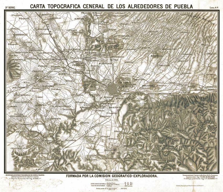
It is interesting to note that the settlement of the first industries is
closely linked to the geography, the topography and hydrography of
the territory around the city at that time (figure 1). Indeed, most of
these factories used the technology of hydraulic mills (others used
the steam machine). In the database of the historic maps of the city
of Puebla, the map of 1862 is the first one to include rural territories,
as it shows the factories, “ranchos” and “haciendas” of that time. But
more than taking into account the representation of the new of
industrialization of the city, this wider frame was designed in 1862, to
resist against the French invader.
In the second half of the 19th century, there is a progressive shift
towards hydroelectric energy. In 1893, 13 factories have their own
18Figure 1: Localization map of the industries (mainly textile ones) along the main rivers around the city, and especially the Atoyac River. From the
original map from 1862: “Croquis de Puebla y sus Alrededores.
Figure 2: From
Puebla on, the
“Ferrocarril
Mexicano” and
the “Ferrocarril
Industrial”, along
the rio Atoyac.
Map from 1928.
Source: Centro
de Investigacion
de los Ferroc-
ariles Mexicanos.
Figure 3 (right):
New polarities
emerge at the
regional scale
thanks to the
implementation
of industries, in-
cluding Puebla,
Tlaxcala, Cholula
and also Atlixco
in the South –
which can not
be seen on the
map. Source:
Secretaria de
Recursos Hidrau- 19
licos.THE RAILWAY
The train was an essential component of public spaces. Some of these
spaces are already used in an
1. The railway museum
today (Museo National
de los Ferrofariles
of the economic and urban develop- informal way, like public spaces
used by pedestrians or bicycles
Mexicanos)
ment of Mexico and Puebla. Today,
2. The ferocaril Inter-
(figure 3). A work would have to oceanico never reached
be accomplished to list all the the ocean
despite the fact that the transport of spaces and rail lines that could
be used to imagine new proj-
3. According to Alfredo
Nieves Medina, from
goods on the Inter-Oceanic line is less ects. Despite some parts of the
network, which were replaced by
the Mexican Railway
Research centre (Centro
significant, the vestiges of the railway
de Documentation y
roads, those lines still exist today. de linvestigation Fer-
roviarias – CEDIF). It is
system are only signs of its past glory. THE PROJECT OF COMMUTERS
TRAIN PUEBLA-TLAXCALA-
true that despite a map
of the federal properties
in the historical centre,
However, those vestiges also have an MEXICO we could not access any
information regarding
important potential.
public properties in
How can we grasp the oppor- Puebla.
tunity of the emerging railway
project linking Puebla-Tlaxcala- 4. Efficient suburb trains
GLORY AND DECREPITUDE OF THE MEXICAN RAILWAY going to Mexico (subur-
Mexico? This line exists today, bans) exist for example
but in the current situation, 4
The massive industrial development of the city is due to its strategic
hours would be needed (with
position between the port of Veracruz and the Mexican capital. Pueb-
an available line) to link Puebla
la’s central train station (1) was the first station in the country, on the
and Mexico, when 2 hours are
first line Veracruz-Puebla-Mexico and its construction was completed
needed if the commuters use the
in 1873: the line “Ferrocaril Mexicano”. Later on, three lines passed
road.
though Puebla: the «Ferrocaril inter-oceanico» (2), the linepuebla-
oaxaca, and the «Ferrocaril mexicano». In 1930, 90% of the transport
of passengers was done through the train, and 10% through routes.
The automobile industry gained more and more over the rail. The rail
was progressively privatized in the 20th century and today, in most of
the cases; it is almost not used anymore for passengers transport.
THE POTENTIALS OF THE RAILWAY
If the railway system was progressively privatized, the lines and the
associated spaces are still public spaces (federal properties). There-
fore, there is a secret reserve of land that is associated to the railways.
Unfortunately, we could not have more details about these proper-
ties on the scale of Puebla’s metropolitan territory (3). What use of
these lines can be imagined today? Should the transport of passen-
gers be reintroduced at a national scale? Or at the metropolitan scale
of Puebla, through the organization of a new public and inter-urban
transport network (4)? Can active transport systems, public spaces
and parks be imagined?
Using the railway system brownfields would have potential to imag-
ine a public transport policy, which would be viable and organized,
and opposed to inefficient a “micro-transport” system based on
concessions. It would also have potential, in order to think a network
20Figure 1: General
topographic map of
Puebla and its sur-
roundings in 1884, on
which some elements
can be clearly seen:
the line towards the
East and towards
Amozoc (Inter-oceani-
co) and then Oaxaca;
the line going to the
South-West through
Atlixco (Inter-Oceani-
co); the line going to
the North-West and
going to Texmelucan
(Inter-oceanico), and
the line through the
North and going
to Mexico through
Tlaxcala (Ferrocarril
Mexicano), and finally
through the South
the “Ferrocaril Car-
bonifero del Sur”.
Source: Mexican Rail-
way Research centre
(Centro de Documen-
tation y de linvesti-
gation Ferroviarias
– CEDIF).
Figure 2: Map of rail-
way Apizaco-Puebla,
from the Ferrocar-
ril Mexicano of
Mexico-Veracruz,
going through
Tlaxcala, 1907.
Source: Mexican
Railway Research
centre (Centro de
Documentation y
de linvestigation
Ferroviarias –
CEDIF).
Figure 3: The new
uses of the railways
lines. Here a part of
the old railway go-
ing from Puebla to
Cholula, and then
to Atlixco, and DF.
The line is still in
use but only a few
trains transporting
goods use the line
every day.
21The industry
in Puebla
Figure 1: parts of the GNP
of the Puebla state in sec-
tors. Source: INEGI
An important part of the economy of Among the manufactured in-
dustries, there is a wide majority
1 Source: Pemex, 2006 /
Atlas Megalopoles Mex-
ico, Antonine Bibardière
the state of Puebla is based on the in- of micro-firms (95% of the firms
employ 1 to 19 persons) that
and Bernard Tallet
dustrial sector, comprising 34% of the
2 Source: Bank of Mexico
generates a small part of the / Atlas Mégalopoles
total incomes (3%). However, a Mexico
GNP of the state. An important part very small part of bigger firms
(0,5% of the firms employ 251
3 Source: Pemex, 2006
/ Atlas Mégalopoles
of this industry is located in Puebla’s workers or more) contributes to
the production of 76,6% of the
Mexico
metropolitan zone.
4 Idem
incomes (5).
5For detailed informa-
WHAT FUTURE FOR THE AUTO- tion, please refer to the
tables in the annex part,
MOBILE INDUSTRY IN PUEBLA?
AN IMPORTANT INDUSTRY SECTOR, WHICH IS MADE IN MAJORITY OF especially the one about
“Information statistics on
THE AUTOMOBILE INDUSTRY
Most of the industrial production the economy and indus-
try in the Puebla state”
relies on the big firms, and espe-
3,4% of the national GNP was made of the GNP of the Puebla state
cially on Volkswagen. We might
in 2010. If the third sector produces more than the half of the GNP
ask what will be the future of the
(64%), the secondary sector represents an important part with 34%.
automobile industry in Puebla,
The basis of the secondary sector is the manufactured industry (26%
as it might become weaker in the
of the GNP) and especially the automobile industry, as it represents
following decades, bearing the
almost the half (47,7%) of the manufactured industry products,
exhaustion of carbon energies
which is 12,5% of the State’s GNP. This production essentially relies on
in mind. On the other side, the
the Volkswagen factory, which is also the fabrication factory that pro-
exhaustion of carbon energies
duces the most in all North America (figure 2). The major part of this
will not necessary lead to the
production (83%) is being exported, mostly into the United States. In
end of the automobile industry,
2010, 80,5% of the exportation of primary and manufactured goods
but might lead to a potential
were exported into the United States’ market (2).
transformation (towards electric
automobiles and renewable
With 1,6 milliards barrels per day the state of Puebla produces also
energies)?
0,6% of the national oil production (1). Therefore, Puebla is the sixth
(among seven) Mexican state producing oil. It is interesting to note
that in Mexico, the major part (83%) of the oil is extracted offshore
(3). The state of Puebla is also on of the smallest gas producer in
Mexico (it is ranked 8th among 9 states), with 0,3% of the national
gas production and 86 millions cubic feet per day (4). Finally, the
electricity production represents 1,2% of the national production,
creating 1849,9 gigawatts/hour, and among them 60% are hydroelec-
tric energy, and about 40% are thermoelectric energy.
22Cars, bus and transport Figure 2: Graph of the
equipment economic characteristics
Food industry of the manufactured
Products based on non industries, regarding the
metallic minerals major activity sectors. The
manufactured industries
Chemical industry represent 26% of the
total GNP of the state of
Textile industry Puebla, and 5% of the
Production of metallic GNP related to manufac-
products turing industries in the
Plastic and rubber indus- whole of Mexico. Source:
try INEGI
Basic metallic industries
Others
Figure 3: Volkswagen in Puebla Figure 4: Volkswagen’s exporta-
tions parts
Figure 5:
Volkswagen in
North America
Figure 6: Map localizing
the industries in the
metropolitan zone. The
industries are con-
centrated in majority
in the Northern part,
following the high-
speed way Mexico-
Veracruz, but they are
also disseminated in
the whole metropolitan
zone. Source: Iracheta,
Alfonso.
23TOURISM
Tourism is one of the reasons why
Puebla’s metropolis is attractive.
Puebla and Cholula are the most pop-
ular and known destinations in the
region.
Figure 1 Puebla’s historical center
in Puebla to 1,6 days, thanks to a marketing champagne
Puebla’s historical centre, listed as a UNESCO World Heritage Site, is probably
promoting its “alternative” assets.
on of the most attractive places in the whole metropolitan zone. Most of the
touristic attractions can be found there: restaurants, museums, craft trades
In Puebla’s municipality, the Valsequillo lac does not have
(ceramic). The Los Fuertes site (with the Loreto and de Guadalupe forts)
any touristic use (despite its potential). This is mostly
became a new important place in the centre and a new touristic attraction;
due to its high percentage of contamination (and the
especially with the events related to the celebration of the 150th anniversary
contamination of tributary rivers).
of the 5th May battle.
TOURISM IN OTHER MUNICIPALITITES OF THE PUEBLA
Among the attractive site in Puebla, there is also the Xanenetla site, located
AND TLAXCALA STATES
at the bottom of de Los Fuertes, that became a new touristic reference
thanks to the interventions delivered by the “Puebla Ciudad Mural” project.
In the territory of Puebla’s metropolis, several archaeo-
This project transformed the façades of the neighbourhood with its “murals”
logical sites exist, like in Cholula or in Tlaxcala, with the
(painted murals). Prior to this, the Xanentla neighbourhood was know and
Cacaztla and Xochitecatl sites. Some of the city centres
judged as being unsafe, and became in between a reference for the city.
are also attractive like those of Tlaxcala, San Andres and
Among the big touristic activities, there is also the zoo (“Africam Safaro”),
San Pedro Cholula or Atlixco. Today, no touristic project is
which occupies a 30 hectares surface, located south of the Puebla municipal-
planned at the intercity scale.
ity.
The archaeological site of San Pedro Cholula is the sec-
Tourism in Puebla represents 9% of the BIP of the metropolitan zone (accord-
ond touristic pole of the region with its massive pyramid.
ing to the Secretary of Economy and Tourism). Cultural tourism is also related
Cholula is only located 15km away from Puebla’s centre.
to two convention centres, touristic walks, churches, architectural heritages
People also come to Cholula to visit the Zocalo or the
and the hotels.
numerous churches (one for every day of the year, ac-
cording to the tradition).
In most of the cases, Puebla is accessed through the Maxico-Veracruz high-
way, despite the international airport Hermanos Serdan, located 26 km away
In the Tlaxcala state, there are also the sites of Cacaxtla y
from the city-center. Flights connecting with the center of Mexico are mostly
Xochitecatl, which are vast archaeological zones located
going to the international airport of Mexico-city.
in the Nativitas town. This Cacaxtla site is wellknown for
its well-preserved pre-Hispanic mural paintings, and the
Even if Puebla as an important touristic attractiveness, it stays a secondary
Xochitecatl site is known for being an important ceremo-
city due to its position towards Mexico, on the road between Mexico and Ve-
nial site (abandoned in the End century after JC).
racruz. On average, the city is visited only for one day. In 2011, the 1.499.292
Tlaxcala is also known for its historical centre and its
tourists stayed on average 1,38 days in Puebla (Secretary of Economy and
Moresque architectures.
Tourism). The municipality would like to increase the time spend by tourists
24LEGEND
Historic centre UNESCO
Archeological sites
Historical centers
National parks
Zoo
Metropolitan area boundary
Natural park Izta - Popo
Cacaxtla - Xochitécalt archeological
site
Tlaxcala city
Natural Park La Malinche
San Luis Huamantla City
Historic centre of Puebla
Africam Safari
Cholula archeological site
Atlixco City
Hermanos Serdán Airport
Figure 2: the most important and attractive poles of Puebla’s metropolitan
Finally, the Atlixco region is attractive for its calm, its region. Source: realised with INEGI data (Zona de Patrimonio Cultural) and
climate, its luxuriant vegetation, its swimming pools and the Altas Megalopoles Mexico.
hotels.
RURAL TOURISM AND ADVENTURE
Around Puebla’s town, there are hiking and alpinism
paths in the Izta-Popo National Park (the Pecho peak
is the highest one). The access to the Popocatepetl is
restrained from since the volcano erupted in 1994. The
Malinche National Park is also an attraction for hikers.
The Tlacala state is in charge of the management of the
pars, through the General Econological Coordination.
The two parks have restricted road access (until specific
places), makes paths and refuge to host the hikers.
Figure 4 (at the top): Tlaxcala).
Figure 5: archaeological Xochitecatl
Figure 3: Cholula’s pyramid site Source: http://www.mexicocity-
explorer.com.mx/tlaxcala.htm
Figure 6: Itza-Popo Natural PArk
source: http://www.mexicoenfotos.com/fotos/puebla/parque-nacional-iztac-
ci- huatl-popocatepetl/mX12182408266366.html
25PUEBLA,
UNIVERSITY TOWN
Puebla is a university town. It is the The wide majority of the universities are private,
but it is a public university (the BUAP) who attracts
city with the most universities per most of the students, has the biggest budget and
the highest number of buildings located in differ-
inhabitant in Mexico, and the second ent parts of the city.
city with the most universities (just TERRITORIAL REPARTITION
after Mexico city). The education sec- Despite the fact that the universities are located
across different parts of the city, they are mainly
tor represents one fifth of the income concentrated around two poles: Puebla’s center
and Angelopolis. In the historical centre, whole
of the city’s economy. buildings and sometimes whole plots are occupied
by universities. In Angelopolis, the universities are
big campuses.
The concentration of universities in Puebla is due to a demand com-
ing from the country’s southern states and neighbouring countries in
Regarding the universities in the historical centre,
the South. It is also a historical vocation of the city.
the Ville du Savoir project needs to we mentioned.
It is managed by the BUAP and was suggested by
The development of an important university offer in Puebla is due to
former administration – which will be detailed in
the concentration of prestigious national institutions in the city and
the 5th chapter.
its proximity with Mexico-city, its central position in the country, and
the fact that Puebla is considered today as being a safe city – in op-
In the Angelopolis district, the installations of
position to other Mexican cities.
universities is due to a state-related urban plan-
ning project, that sold land at lower prices to “noble
HIGHER EDUCATION IN MEXICO
institutions”, like hospitals and universities, in order
to revalorize the zone. These plots were the “ejidos”
About 190.000 students are currently living in Puebla, studying on
that the State could expropriate thanks to the law
almost 200 university related institutions, public and private. This
that enabled their privatisation in the 1990s.
high number is due to the existence of smaller private institutions,
which quality is not always proved and who are called “patitos” insti-
PUEBLA UNIVERSITY CAPITAL – PCUM
tutions (literally “small ducks”). The big majority of these institutions
is located in the town of Puebla and San Andre Cholula.
In order to consolidate the university town status of
Puebla at the national and international scale, the
The majority of the students study to graduate in a 5 years degree
PCUM (Puebla Capital Universitaria of Mexico) was
giving the “licenciatura” title. The favourite formations are law, firm
created in 2011.
administration, education and pedagogy, computability, psychology,
informative, mechanic, tourism and communication (according to
The PCUM is a collaboration agreement between
E-Consulta, 2009).
the 16 biggest universities in Puebla. The goals are
to initiate or to consolidate the academic relations
Despite its efforts to develop the research, only 1% of the students
between the universities and to create links be-
are doing a PhD.
tween the university education and the education
of firms, and also with the civil society.
26Figure 1:Contribution to
the BIP
Source: “Puebla, vocacion
economica”
In a similar way, the goal is to give a power to act to universities, in
order to have an impact on the decision process (especially regarding
the planning system and urban projects).
Despite its recent implementation, the PCUM is already recognised
at an international level. In March 2012, it was mentioned among
the best practice projects for the development and management
of knowledge, which was presented to the Congres of the centre
Iberoamerican of strategic urban development (Congreso del Centro
Ideroamerican de Desarrollo Estratégico Urbano – CIEDU), in Barce-
Top UNIVERSITY TYPE Bachelor Master PhD
1 UNAM - D.F. Public
Figure 2: Proportion of Students by education level.
2 UAM - D.F Public
Source: “opportunidades para la inversion en el Estado
3 UANL - Nuevo León Public de Puebla”
4 BUAP - Puebla Public
5 UDLA - Puebla Private
Figure 3: Ranking table of national universities
Source: http://mejoresuniversidadesdemexico.mx/?q=ranking
Figure 4: Quantity of students in the major universities
Source: PCUM / information delivered by IMPLAN
27También puede leer